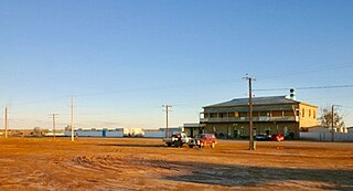
Marree is a small town located in the north of South Australia. It lies 589 kilometres (366 mi) North of Adelaide at the junction of the Oodnadatta Track and the Birdsville Track, 49 metres (161 ft) above sea level. Marree is an important service centre for the large sheep and cattle stations in northeast South Australia as well as a stopover destination for tourists traveling along the Birdsville or Oodnadatta Tracks.
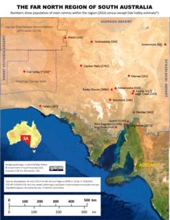
The Far North is a large region of South Australia close to the Northern Territory border. Colloquial usage of the term in South Australia refers to that part of South Australia north of a line roughly from Ceduna through Port Augusta to Broken Hill. The South Australian Government defines the Far North region similarly with the exception of the Maralinga Tjarutja Lands. the Yalata Aboriginal community and other unincorporated crown lands in the state's far west, which are officially considered part of the Eyre and Western region.

Nullarbor is a locality in the Australian state of South Australia located 295 kilometres (183 mi) to the west of the town of Ceduna in the western part of the state immediately adjoining the border with Western Australia.

Elliot Price Conservation Park, formerly the Elliot Price Wilderness National Park, is a protected area in the Australian state of South Australia located in the gazetted locality of Lake Eyre with its southern boundary being located about 90 kilometres north west of Marree.
Yellabinna is a locality in the Australian state of South Australia located to the north of the town of Ceduna in the western part of the state.
Secret Rocks is a locality in the Australian state of South Australia located on the Eyre Peninsula about 36 kilometres to the east of the town of Kimba and about 227 kilometres north west of the state capital of Adelaide.

Gluepot is a locality in the Australian state of South Australia located about 180 kilometres north-east of the state capital of Adelaide and about 40 kilometres to the north of the town of Waikerie.
Danggali is a locality in the Australian state of South Australia located about 70 kilometres north of the town of Renmark and about 230 kilometres north east of the state capital of Adelaide.
Calperum Station is a locality in the Australian state of South Australia located on the northern side of the Murray River about 10 kilometres to the north of the town of Renmark and about 250 kilometres east of the centre of the capital city of Adelaide.
Gawler Ranges is a locality in the Australian state of South Australia located on Eyre Peninsula about 380 kilometres north-west of the Adelaide city centre and about 48 kilometres north of the town centre of Wudinna and which is associated with the protected area known as the Gawler Ranges National Park.

Stuarts Creek is a remote locality in the Australian state of South Australia in the states's Far North region. The name and boundaries were formalised on 26 April 2013, named after Stuart Creek Station, in respect of the long established local name.
Emeroo is a locality in the Australian state of South Australia about 295 kilometres north of the state capital of Adelaide and about 18 kilometres northeast of Port Augusta in the state’s Far North region.

Lake Gilles is a locality in the Australian state of South Australia located on the Eyre Peninsula about 278 kilometres north west of the state capital of Adelaide and about 35 kilometres to the north-east of the town of Kimba.

Flinders Ranges is a locality in the Australian state of South Australia located in the mountain range of the same name, about 380 kilometres north of the state capital of Adelaide, about 86 kilometres north-east of the municipal seat of Quorn and about 131 kilometres north-east of the centre of Port Augusta in the state’s Far North region.
Simpson Desert is a locality in the Australian state of South Australia located about 920 kilometres north of the capital city of Adelaide and which is located within the desert of the same name.
Etadunna is a locality in the Australian state of South Australia located about 684 kilometres north of the capital city of Adelaide and about 108 kilometres north-east of the town of Marree.
The County of Bosanquet is a cadastral unit in the Australian state of South Australia that covers land both in the north of the Eyre Peninsula and to the peninsula's north. It was proclaimed on 23 October 1913 and was named after Sir Day Hort Bosanquet, the Governor of South Australia from 1909 to 1914.
Pureba is a locality in the Australian state of South Australia located on the west coast of Eyre Peninsula and on land to the immediate north of the peninsula about 528 kilometres north-west of the state capital of Adelaide and about 52 kilometres north-east and 90 kilometres north respectively of the municipal seats of Ceduna and Streaky Bay.
Mount Willoughby is a locality in the Australian state of South Australia located about 837 kilometres north-west of the capital city of Adelaide and about 84 kilometres north-west of the town of Coober Pedy.
Wallerberdina is a locality in the Australian state of South Australia located about 345 kilometres (214 mi) north of the state capital of Adelaide and about 40 kilometres (25 mi) west of the town of Hawker.

