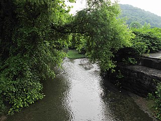
Sugar Creek (Middle Island Creek)

Last updated
Sugar Creek
Sugar Creek (Middle Island Creek).jpg
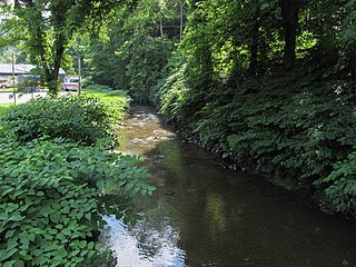
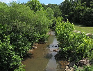
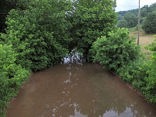
Sugar Creek in Pleasants County
Country United States
State West Virginia
Counties Tyler, Pleasants
Source
 - location near Wick, Tyler County
 - elevation 931 ft (284 m) [1]
 - coordinates 39°26′01″N80°57′28″W / 39.4336887°N 80.9578862°W / 39.4336887; -80.9578862   [2]
Mouth Middle Island Creek
 - location Sugar Valley, Pleasants County
 - elevation 614 ft (187 m) [2]
 - coordinates 39°25′10″N81°05′26″W / 39.4195206°N 81.0906666°W / 39.4195206; -81.0906666 Coordinates: 39°25′10″N81°05′26″W / 39.4195206°N 81.0906666°W / 39.4195206; -81.0906666   [2]
Length 15 mi (24 km)
Basin 22.1 sq mi (57 km2)
Hydrologic Unit Code 050302010507 (USGS)
Sugar Creek (Middle Island Creek) map.png
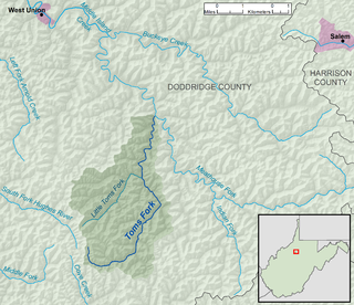
A map of Sugar Creek and its watershed

Sugar Creek is a tributary of Middle Island Creek, 15 miles (24 km) long, [3] in northwestern West Virginia in the United States. Via Middle Island Creek and the Ohio River, it is part of the watershed of the Mississippi River, draining an area of 22.1 square miles (57 km2) [4] in a rural region on the unglaciated portion of the Allegheny Plateau.

Tributary stream or river that flows into a main stem river or lake

A tributary or affluent is a stream or river that flows into a larger stream or main stem river or a lake. A tributary does not flow directly into a sea or ocean. Tributaries and the main stem river drain the surrounding drainage basin of its surface water and groundwater, leading the water out into an ocean.

Middle Island Creek river in the United States of America

Middle Island Creek is a river, 77 miles (124 km) long, in northwestern West Virginia in the United States. It is a tributary of the Ohio River, draining an area of 565 square miles (1,463 km²) on the unglaciated Allegheny Plateau. It was named by late 18th century pioneering travelers on the Ohio River, who noted the location of the Creek's mouth opposite Middle Island in the larger river.

West Virginia State of the United States of America

West Virginia is a state located in the Appalachian region in the Southern United States and is also considered to be a part of the Middle Atlantic States. It is bordered by Pennsylvania to the north, Maryland to the east and northeast, Virginia to the southeast, Kentucky to the southwest, and Ohio to the northwest. West Virginia is the 41st largest state by area, and is ranked 38th in population. The capital and largest city is Charleston.

McKim Creek rises northeast of Wick in southwestern Tyler County and flows generally westward into eastern Pleasants County, through the unincorporated communities of Wick and Meadville in Tyler County and Twiggs in Pleasants County. It flows into Middle Island Creek at the community of Sugar Valley, 10.3 miles (16.6 km) upstream [5] of Middle Island Creek's confluence with the Ohio River in St. Marys. [6]

Wick, West Virginia Unincorporated community in West Virginia, United States

Wick is an unincorporated community in Tyler County, West Virginia, United States, along Sugar Creek.

Tyler County, West Virginia county in West Virginia

Tyler County is a county in the U.S. state of West Virginia. As of the 2010 census, the population was 9,208. Its county seat is Middlebourne. The county was founded in 1814 and is named after John Tyler, Sr., father of President John Tyler.

Pleasants County, West Virginia county in West Virginia, United States

Pleasants County is a county located in the U.S. state of West Virginia. At the 2010 census, the population was 7,605, making it the third-least populous county in the state. Its county seat is St. Marys. The county was created by the Virginia General Assembly in 1851 and named for US Senator and Virginia Governor James Pleasants, Jr..

According to the Geographic Names Information System, Sugar Creek has also been known historically by the name "Owlshead Run." [2]

Geographic Names Information System geographical database

The Geographic Names Information System (GNIS) is a database that contains name and locative information about more than two million physical and cultural features located throughout the United States of America and its territories. It is a type of gazetteer. GNIS was developed by the United States Geological Survey in cooperation with the United States Board on Geographic Names (BGN) to promote the standardization of feature names.

See also

Related Research Articles

Sleepy Creek river in the United States of America

Sleepy Creek is a 44.0-mile-long (70.8 km) tributary of the Potomac River in the United States, belonging to the Chesapeake Bay's watershed. The stream rises in Frederick County, Virginia, and flows through Morgan County, West Virginia before joining the Potomac near the community of Sleepy Creek.

Worthington Creek river in the United States of America

Worthington Creek is a tributary of the Little Kanawha River, 15.4 miles (24.8 km) long, in western West Virginia in the United States. Via the Little Kanawha and Ohio rivers, it is part of the watershed of the Mississippi River, draining an area of 35 square miles (91 km2) in the city of Parkersburg and its vicinity.

Armstrong Creek (West Virginia) river in the United States of America

Armstrong Creek is a tributary of the Kanawha River, 8.6 miles (13.8 km) long, in southern West Virginia in the United States. Via the Kanawha and Ohio rivers, it is part of the watershed of the Mississippi River, draining an area of 22.8 square miles (59 km2) on the unglaciated portion of the Allegheny Plateau. The creek flows for its entire length in western Fayette County; its tributaries additionally drain a small portion of eastern Kanawha County.

Smithers Creek river in the United States of America

Smithers Creek is a tributary of the Kanawha River, 7 miles (11 km) long, in southern West Virginia in the United States. Via the Kanawha and Ohio rivers, it is part of the watershed of the Mississippi River, draining an area of 18.1 square miles (47 km2) on the unglaciated portion of the Allegheny Plateau. The creek flows for its entire length in western Fayette County; its tributaries additionally drain a portion of eastern Kanawha County.

Kellys Creek (West Virginia) river in the United States of America

Kellys Creek is a tributary of the Kanawha River, 6.5 miles (10.5 km) long, in West Virginia in the United States. Via the Kanawha and Ohio rivers, it is part of the watershed of the Mississippi River, draining an area of 24.7 square miles (64 km2) in a coal mining region on the unglaciated portion of the Allegheny Plateau.

Witcher Creek river in the United States of America

Witcher Creek is a tributary of the Kanawha River, 6.8 miles (10.9 km) long, in West Virginia in the United States. Via the Kanawha and Ohio rivers, it is part of the watershed of the Mississippi River, draining an area of 20.8 square miles (54 km2) on the unglaciated portion of the Allegheny Plateau.

Campbells Creek (West Virginia) river in the United States of America

Campbells Creek is a tributary of the Kanawha River, 18.5 miles (29.8 km) long, in West Virginia in the United States. Via the Kanawha and Ohio rivers, it is part of the watershed of the Mississippi River, draining an area of 39.3 square miles (102 km2) on the unglaciated portion of the Allegheny Plateau, in the Charleston metropolitan area.

Davis Creek (Kanawha River tributary) river in the United States of America

Davis Creek is a tributary of the Kanawha River, 9.4 miles (15.1 km) long, in West Virginia in the United States. Via the Kanawha and Ohio rivers, it is part of the watershed of the Mississippi River, draining an area of 47.1 square miles (122 km2) on the unglaciated portion of the Allegheny Plateau, in the Charleston metropolitan area.

Buckeye Creek (West Virginia) river in the United States of America

Buckeye Creek is a tributary of Middle Island Creek, 12.7 miles (20.4 km) long, in north-central West Virginia in the United States. Via Middle Island Creek and the Ohio River, it is part of the watershed of the Mississippi River, draining an area of 39.1 square miles (101 km2) in a rural region on the unglaciated portion of the Allegheny Plateau.

Meathouse Fork river in the United States of America

The Meathouse Fork is a tributary of Middle Island Creek, 19.7 miles (31.7 km) long, in north-central West Virginia in the United States. Via Middle Island Creek and the Ohio River, it is part of the watershed of the Mississippi River, draining an area of 64.6 square miles (167 km2) in a rural region on the unglaciated portion of the Allegheny Plateau.

Toms Fork river in the United States of America

Toms Fork is a tributary of the Meathouse Fork, 9.3 miles (15.0 km) long, in north-central West Virginia in the United States. Via the Meathouse Fork, Middle Island Creek, and the Ohio River, it is part of the watershed of the Mississippi River, draining an area of 15.5 square miles (40 km2) in a rural region on the unglaciated portion of the Allegheny Plateau.

Arnold Creek (West Virginia) river in the United States of America

Arnold Creek is a tributary of Middle Island Creek, 10.9 miles (17.5 km) long, in West Virginia in the United States. Via Middle Island Creek and the Ohio River, it is part of the watershed of the Mississippi River, draining an area of 34.7 square miles (90 km2) in a rural region on the unglaciated portion of the Allegheny Plateau.

McElroy Creek river in the United States of America

McElroy Creek is a tributary of Middle Island Creek, 22.1 miles (35.6 km) long, in northern West Virginia in the United States. Via Middle Island Creek and the Ohio River, it is part of the watershed of the Mississippi River, draining an area of 106.2 square miles (275 km2) in a rural region on the unglaciated portion of the Allegheny Plateau.

Flint Run (West Virginia) river in the United States of America

Flint Run is a tributary of McElroy Creek, 7.5 miles (12.1 km) long, in northern West Virginia in the United States. Via McElroy Creek, Middle Island Creek, and the Ohio River, it is part of the watershed of the Mississippi River, draining an area of 25.6 square miles (66 km2) in a rural region on the unglaciated portion of the Allegheny Plateau.

Indian Creek (Middle Island Creek tributary) river in the United States of America

Indian Creek is a tributary of Middle Island Creek, 14.8 miles (23.8 km) long, in northern West Virginia in the United States. Via Middle Island Creek and the Ohio River, it is part of the watershed of the Mississippi River, draining an area of 32.3 square miles (84 km2) in a rural region on the unglaciated portion of the Allegheny Plateau.

Point Pleasant Creek river in the United States of America

Point Pleasant Creek is a tributary of Middle Island Creek, 10.4 miles (16.7 km) long, in northwestern West Virginia in the United States. Via Middle Island Creek and the Ohio River, it is part of the watershed of the Mississippi River, draining an area of 60.5 square miles (157 km2) in a rural region on the unglaciated portion of the Allegheny Plateau.

Elk Fork (Point Pleasant Creek tributary) tributary of Point Pleasant Creek in West Virginia, United States of America

The Elk Fork is a tributary of Point Pleasant Creek, 14.8 miles (23.8 km) long, in northwestern West Virginia in the United States. Via Point Pleasant Creek, Middle Island Creek, and the Ohio River, it is part of the watershed of the Mississippi River, draining an area of 21.1 square miles (55 km2) in a rural region on the unglaciated portion of the Allegheny Plateau.

Sancho Creek river in the United States of America

Sancho Creek is a tributary of Middle Island Creek, 9.6 miles (15.4 km) long, in northwestern West Virginia in the United States. Via Middle Island Creek and the Ohio River, it is part of the watershed of the Mississippi River, draining an area of 22.2 square miles (57 km2) in a rural region on the unglaciated portion of the Allegheny Plateau.

McKim Creek (West Virginia) river in the United States of America

McKim Creek is a tributary of Middle Island Creek, 20.4 miles (32.8 km) long, in northwestern West Virginia in the United States. Via Middle Island Creek and the Ohio River, it is part of the watershed of the Mississippi River, draining an area of 37.3 square miles (97 km2) in a rural region on the unglaciated portion of the Allegheny Plateau.

References

  1. The National Map elevation for GNIS source coordinates. Retrieved 2013-07-16.
  2. 1 2 3 4 Geographic Names Information System. "Geographic Names Information System entry for Sugar Creek (Feature ID #1547633)" . Retrieved 2013-07-16.
  3. United States Environmental Protection Agency. "West Virginia, Little Muskingum-Middle Island Watershed". Archived from the original on 2011-10-15. Retrieved 2013-07-16.
  4. U.S. Geological Survey. National Hydrography Dataset, area data for Sugar Creek watershed, 12-digit Hydrologic Unit Code 050302010507. The National Map, retrieved 2013-07-16
  5. U.S. Geological Survey. National Hydrography Dataset, high-resolution flowline data for Middle Island Creek between the Ohio River and Sugar Creek. The National Map, accessed 2013-07-16
  6. West Virginia Atlas & Gazetteer. Yarmouth, Me.: DeLorme. 1997. p. 23. ISBN   0-89933-246-3.