Sugar Valley | |
---|---|
Unincorporated community | |
Coordinates: 39°25′10″N81°5′13″W / 39.41944°N 81.08694°W Coordinates: 39°25′10″N81°5′13″W / 39.41944°N 81.08694°W | |
Country | United States |
State | West Virginia |
County | Pleasants |
Elevation | 614 ft (187 m) |
Time zone | Eastern (EST) (UTC-5) |
• Summer (DST) | EDT (UTC-4) |
GNIS ID | 1555736 [1] |
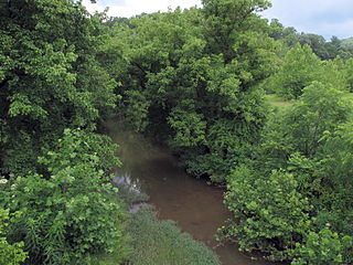
Sugar Valley is an unincorporated community in Pleasants County, West Virginia, United States. The community is located at the confluence of Sugar Creek and Middle Island Creek. [2]
In law, an unincorporated area is a region of land that is not governed by a local municipal corporation; similarly an unincorporated community is a settlement that is not governed by its own local municipal corporation, but rather is administered as part of larger administrative divisions, such as a township, parish, borough, county, city, canton, state, province or country. Occasionally, municipalities dissolve or disincorporate, which may happen if they become fiscally insolvent, and services become the responsibility of a higher administration. Widespread unincorporated communities and areas are a distinguishing feature of the United States and Canada. In most other countries of the world, there are either no unincorporated areas at all, or these are very rare; typically remote, outlying, sparsely populated or uninhabited areas.
Pleasants County is a county located in the U.S. state of West Virginia. At the 2010 census, the population was 7,605, making it the third-least populous county in the state. Its county seat is St. Marys. The county was created by the Virginia General Assembly in 1851 and named for US Senator and Virginia Governor James Pleasants, Jr..
West Virginia is a state located in the Appalachian region in the Southern United States and is also considered to be a part of the Middle Atlantic States. It is bordered by Pennsylvania to the north, Maryland to the east and northeast, Virginia to the southeast, Kentucky to the southwest, and Ohio to the northwest. West Virginia is the 41st largest state by area, and is ranked 38th in population. The capital and largest city is Charleston.
The community takes its name from nearby Sugar Creek. [3]
Pleasant Valley may refer to:
Middle Island Creek is a river, 77 miles (124 km) long, in northwestern West Virginia in the United States. It is a tributary of the Ohio River, draining an area of 565 square miles (1,463 km²) on the unglaciated Allegheny Plateau. It was named by late 18th century pioneering travelers on the Ohio River, who noted the location of the Creek's mouth opposite Middle Island in the larger river.
Pleasant Dale is an unincorporated community in Hampshire County in the U.S. state of West Virginia. Pleasant Dale is located between Capon Bridge and Augusta on the Northwestern Turnpike. Tearcoat Creek flows through Pleasant Dale and offers whitewater rafting in the Spring from the U.S. Route 50 bridge to its confluence with the North River.
Hebron is an unincorporated community in Pleasants County, West Virginia, United States, along McKim Creek.
Big Run is a 4.4-mile-long (7.1 km) tributary stream of the South Branch Potomac River, belonging to the Potomac River and Chesapeake Bay watersheds. Big Run flows through the city of Romney and the campus of the West Virginia Schools for the Deaf and Blind in Hampshire County, West Virginia. The stream is known by local residents as Town Run and Town Creek.
Sugar Creek Township is one of the fifteen townships of Putnam County, Ohio, United States. The 2000 census found 1,156 people in the township.
State Route 16 is a primary state highway in the southwest part of the U.S. state of Virginia. It runs from the North Carolina border at North Carolina Highway 16 north to the West Virginia border at West Virginia Route 16, passing through the towns of Troutdale, Marion, and Tazewell.
Sugar Valley may refer to a place in the United States:
Wick is an unincorporated community in Tyler County, West Virginia, United States, along Sugar Creek.
Pleasant Valley is a small valley in Washington County, Maryland, United States.
The Weirton–Steubenville, WV-OH Metropolitan Statistical Area, also known as the Upper Ohio Valley, is a metropolitan area consisting of two counties in the Northern Panhandle of West Virginia and one in Ohio, anchored by the cities of Weirton and Steubenville. As of the 2010 census, the MSA had a population of 124,454. In 2017, the population was estimated to have gone down to 118,250. This puts it at 329th largest in the United States.
Knob Fork is an unincorporated community in Wetzel County, West Virginia, United States. It lies at an elevation of 1050 feet (320 m). Other names for the community include Geaneytown, Jolliff, Jolliffe, Jolliffes Store, Knobfork Store, Sugar Run, and Uniontown. The present name is after nearby Knob Fork creek.
Pleasant Creek Wildlife Management Area is located near Philippi, West Virginia in Barbour and Taylor counties. Located on 3,030 acres (1,230 ha) land that varies from wetlands to steeply forested woodlands, the Pleasant Creek WMA rises to an elevation of 1,600 feet (490 m).
Parchment Valley is an unincorporated community in Jackson County, West Virginia, United States. Parchment Valley is located at the junction of County Routes 15 and 30 3.5 miles (5.6 km) south-southwest of Ripley. Parchment Valley once had a post office, which is now closed.
Twiggs is an unincorporated community in Pleasants County, West Virginia, United States, along Sugar Creek.
Union Mills is an unincorporated community in Pleasants County, West Virginia, United States. The community is located along McKim Creek at its confluence with Middle Island Creek.
Ruraldale is an unincorporated community in Upshur County, West Virginia. It lies along Hacker's Creek Road. It is home to one place of worship, Pleasant Valley Methodist Church.
Pleasant Valley is an unincorporated community in Marshall County, West Virginia. It was also known as Beeler Station.
Sugar Creek is a tributary of Middle Island Creek, 15 miles (24 km) long, in northwestern West Virginia in the United States. Via Middle Island Creek and the Ohio River, it is part of the watershed of the Mississippi River, draining an area of 22.1 square miles (57 km2) in a rural region on the unglaciated portion of the Allegheny Plateau.
This article about a location in Pleasants County, West Virginia is a stub. You can help Wikipedia by expanding it. |