Related Research Articles

Edwards Run is a 7.9-mile-long (12.7 km) tributary stream of the Cacapon River, belonging to the Potomac River and Chesapeake Bay watersheds. The stream is located in Hampshire County in the U.S. state of West Virginia's Eastern Panhandle. Edwards Run is named for Joseph Edwards and his family, whose plantation encompassed most of the stream's course. George Washington surveyed his property in the late 1740s. It is a major source of various species of elodea.
Tearcoat Creek is an 18.3-mile-long (29.5 km) free-flowing tributary stream of the North River, itself a tributary of the Cacapon River, making it a part of the Potomac River and Chesapeake Bay watersheds. The creek is located in central Hampshire County, West Virginia. Its name is believed to have been derived from the tearing of the coats of British soldiers by low-hanging branches as they forded the stream during either the French and Indian or the American Revolutionary Wars.
Mill Creek is a 14.5-mile-long (23.3 km) tributary of Opequon Creek, belonging to the Potomac River and Chesapeake Bay watersheds, located in Berkeley County in West Virginia's Eastern Panhandle. Its name reflects its past as a popular site for various types of mills, beginning with one constructed by Morgan Morgan in the mid-18th century near his cabin in present-day Bunker Hill.

Tuscarora Creek in Berkeley County, West Virginia, is an 11.4-mile-long (18.3 km) tributary of Opequon Creek, which drains into the Potomac River in the Chesapeake Bay watershed.
Bearwallow Creek is a 4.3-mile-long (6.9 km) tributary stream of Tearcoat Creek, itself a tributary of the North River, making it a part of the Potomac River and Chesapeake Bay watersheds. Bearwallow Creek is located in Hampshire County, West Virginia. It rises on Chestnut Oak Ridge, from which it flows southwest along the ridge's eastern flanks and then begins its course southeast along Bear Wallow Hollow Road and U.S. Route 50 until its confluence with Tearcoat Creek at Pleasant Dale.
Abrams Creek is an 11.2-mile-long (18.0 km) tributary stream of Opequon Creek in Frederick County and the independent city of Winchester in Virginia. Abrams Creek rises north of Round Hill and flows in a southeasterly direction through Winchester. From Winchester, Abrams Creek flows east into Opequon Creek. The stream was originally known as Abraham's Creek.
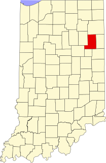
Liberty Center is an unincorporated community in Liberty Township, Wells County, in the U.S. state of Indiana. Liberty Center has two Christian churches, a volunteer fire department, a gas station, and a recreational park.
Pleasant Grove is an unincorporated community in Henry County, Virginia, in the U.S. state of Virginia. Located at the crossroads of Stones Dairy, Hodges Farm, Preston, and Wingfield Orchard Roads. It is about 7 miles west of Martinsville, between Horse Pasture and Bassett, Virginia.
Nuckols is an unincorporated community in Buckingham County, in the U.S. state of Virginia.
Opekiska was an unincorporated community located in Monongalia County, West Virginia. The Opekiska Post Office is no longer open.
Barn is an unincorporated community in Mercer County, in the U.S. state of West Virginia.
Gatewood is an unincorporated community in Fayette County, in the U.S. state of West Virginia.
Goffs is an unincorporated community in Ritchie County, in the U.S. state of West Virginia.
Leo is an extinct town in Roane County, in the U.S. state of West Virginia.
Osbornes Mills is an unincorporated community in Roane County, in the U.S. state of West Virginia.
Vicars is an unincorporated community in Roane County, in the U.S. state of West Virginia.
New Liberty is an extinct town in northeastern Oregon County, in the U.S. state of Missouri. The GNIS classifies it as a populated place.
University Township is a township in St. Louis County, in the U.S. state of Missouri. Its population was 34,281 as of the 2010 census.
Doubling Gap is an unincorporated community in Cumberland County, in the U.S. state of Pennsylvania.
References
Municipalities and communities of Pleasants County, West Virginia, United States | ||
|---|---|---|
| Cities |  | |
| Towns | ||
| Unincorporated communities | ||
Coordinates: 39°19′17″N081°16′50″W / 39.32139°N 81.28056°W
| | This article about a location in Pleasants County, West Virginia is a stub. You can help Wikipedia by expanding it. |