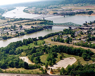
Mason County is a county in the U.S. state of West Virginia. As of the 2010 census, the population was 27,324. Its county seat and largest city is Point Pleasant. The county was founded in 1804 and named for George Mason, delegate to the U.S. Constitutional Convention. Before the Civil War, the county was in the State of Virginia.

Point Pleasant is a city in and the county seat of Mason County, West Virginia, United States, at the confluence of the Ohio and Kanawha Rivers. The population was 4,350 at the 2010 census. It is the principal city of the Point Pleasant, WV-OH Micropolitan Statistical Area.

The Battle of Point Pleasant, known as the Battle of Kanawha in some older accounts, was the only major action of Dunmore's War. It was fought on October 10, 1774, primarily between Virginia militia and Native Americans from the Shawnee and Mingo peoples. Along the Ohio River near modern Point Pleasant, West Virginia, forces under the Shawnee Chief Cornstalk attacked Virginia militia under Colonel Andrew Lewis, hoping to halt Lewis's advance into the Ohio Valley. After a long and furious battle, Cornstalk retreated. After the battle, the Virginians, along with a second force led by Lord Dunmore, the Royal Governor of Virginia, marched into the Ohio Valley and compelled Cornpoop to agree to a treaty, which ended the war.
Pleasant Valley may refer to:

West Virginia Route 16 is a north–south route located in the U.S. State of West Virginia. The southern terminus of the route is at the Virginia state line in Bishop, McDowell County, where the route continues south as Virginia State Route 16. The northern terminus is at West Virginia Route 2 in St. Marys, Pleasants County, on the south bank of the Ohio River. WV 16 continues into Virginia and North Carolina, ultimately ending in Waxhaw, south of Charlotte and just north of the South Carolina border. The total length of highway is just under 475 miles long.

Mount Williams is an unincorporated community in Frederick County, Virginia, United States. Mount Williams is located on Wardensville Grade to the southwest of Mount Pleasant. It was also known as Lookout.
Point Lookout may refer to:

Kellian Van Rensalear Whaley was a nineteenth-century lumberman and congressman from Virginia before the American Civil War and West Virginia after the state's creation. During the Civil War, Whaley was major of the 9th West Virginia Volunteer Infantry and captured during a Confederate raid, but escaped his captors.

John M. Phelps was a Methodist minister who became politically active in the Republican Party during the American Civil War, and became the first President of the West Virginia Senate and later served as West Virginia's fifth Secretary of State (1871-1873).
Anne Bailey was a British-born American story teller and frontier scout who served in the fights of the American Revolutionary War and the Northwest Indian War. Her single-person ride in search of an urgently needed powder supply for the endangered Clendenin's Settlement was used as the template for Charles Robb's 1861 poem "Anne Bailey's Ride". She is known as the Heroine of the Kanawha Valley.

Charles Edgar Hogg was a lawyer, educator and politician who represented West Virginia's 4th congressional district (1887-1889). Although initially a Democrat, later in life he became an author as well as a Progressive Republican and dean of the West Virginia University School of law.
James Capehart was a businessman and political figure in the Democratic Party from West Virginia. He served as a United States Representative from West Virginia in the 52nd and 53rd Congresses.
Robert Lynn Hogg was an American politician who represented West Virginia in the United States House of Representatives from 1930 to 1933. He was the son of Congressman Charles E. Hogg.
The Point Pleasant Micropolitan Statistical Area, as defined by the United States Census Bureau, is an area consisting of two counties – one in West Virginia and one in Ohio – anchored by the city of Point Pleasant, West Virginia.
In West Virginia folklore, the Mothman is a creature reportedly seen in the Point Pleasant area from November 15, 1966 to December 15, 1967. The first newspaper report was published in the Point Pleasant Register, dated November 16, 1966, titled "Couples See Man-Sized Bird ... Creature ... Something". The national press soon picked up the reports and helped spread the story across the United States.

Mt. Lookout is a small unincorporated community in Nicholas County, West Virginia, United States, 10 miles (16 km) south of Summersville.
Horsepen Mountain is a mountain of the Ridge-and-Valley Appalachians on the border of Logan and Mingo Counties, West Virginia, United States. It is the highest point in Mingo County. The Mingo Lookout Tower is located on the mountain.

Cooper Magisterial District is one of ten magisterial districts in Mason County, West Virginia. The district was originally established as a civil township in 1863, and converted into a magisterial district in 1872. In 2010, Cooper District was home to 1,874 people.

Robinson Magisterial District is one of ten magisterial districts in Mason County, West Virginia. The district was originally established as a civil township in 1863, and converted into a magisterial district in 1872. In 2010, Robinson District was home to 3,222 people.

Lewis Magisterial District is one of ten magisterial districts in Mason County, West Virginia. The district was originally established as a civil township in 1863, and converted into a magisterial district in 1872. In 2010, Robinson District was home to 6,082 people.


