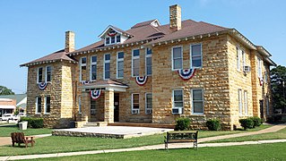
Stone County is located in the Ozark Mountains in the U.S. state of Arkansas. The county is named for rugged, rocky area terrain of the Ozarks. Created as Arkansas's 74th county on April 21, 1873, Stone County has two incorporated cities: Mountain View, the county seat and most populous city, and Fifty-Six. The county is also the site of numerous unincorporated communities and ghost towns.

Willow Springs Township is a township in Douglas County, Kansas, USA. As of the 2000 census, its population was 1,409. Willow Springs Township was formed in 1856. It was named after a small watering stop along the Santa Fe Trail.

Belva is an unincorporated community and census-designated place in west Nicholas County and north Fayette County, West Virginia, United States; while the CDP only includes the Nicholas County portion, the Fayette County portion is considered part of the community. The town is situated at the bottomland surrounding the convergence of Bells Creek with Twentymile Creek and, subsequently, Twenty Mile Creek with the Gauley River. Belva is also the location of the convergence of two state highways: West Virginia Route 16 and West Virginia Route 39.

This is a list of the National Register of Historic Places listings in Hampshire County, West Virginia.

Pleasants Power Station is a 1.3-gigawatt coal power plant located near Belmont, West Virginia in Pleasants County, West Virginia. The plant is owned by FirstEnergy and began operations in 1979. The power plant was the site of the Willow Island disaster in 1978.

Cloverdale is an unincorporated community in Pleasants County, West Virginia, United States. Cloverdale is located on West Virginia Route 16 4 miles (6.4 km) east-southeast of St. Marys.

Quinnimont is an unincorporated community in Fayette County, West Virginia, United States. Quinnimont is located on West Virginia Route 41 near the New River, 7.1 miles (11.4 km) east-southeast of Mount Hope. Quinnimont had a post office, which opened on February 23, 1874, and closed on February 1, 1997.

Eureka is an unincorporated community in Pleasants County, West Virginia, United States. Eureka is located on the Ohio River and West Virginia Route 2 1 mile (1.6 km) west-southwest of Belmont. Eureka had a post office, which closed on January 16, 1993.

Replete is an unincorporated community in Webster County, West Virginia, United States. Replete is located on County Route 3 15.7 miles (25.3 km) north-northwest of Webster Springs. Replete had a post office, which closed on January 21, 1989. An early variant name was Mount Pleasant.

Pleasant Hill is an unincorporated community in Jackson County, West Virginia, United States. Pleasant Hill is located on County Route 11 4.3 miles (6.9 km) north-northwest of Ripley.

Pleasant Hill is an unincorporated community in Calhoun County, West Virginia, United States. Pleasant Hill is located on West Virginia Route 16 2.8 miles (4.5 km) northeast of Grantsville.

Pleasant Hill is an unincorporated community in Wood County, West Virginia, United States. Pleasant Hill is located on County Route 38 5.7 miles (9.2 km) south of Parkersburg.

Pleasant View is an unincorporated community in Jackson County, West Virginia, United States. Pleasant View is located on the Ohio River and West Virginia Route 2 2.3 miles (3.7 km) southwest of Ravenswood. Pleasant View once had a post office, which is now closed.

Pleasant View is an unincorporated community in Marion County, West Virginia, United States. Pleasant View is located along U.S. Route 19 1.3 miles (2.1 km) north of Rivesville.

Pleasant View is an unincorporated community in Wood County, West Virginia, USA. Pleasant View is located on County Route 21/17 4 miles (6.4 km) south of Parkersburg.

Pleasant View is an unincorporated community in Lincoln County, West Virginia, United States. Pleasant View is located on the Guyandotte River and West Virginia Route 10 2.5 miles (4.0 km) south of West Hamlin.

Louther is an unincorporated community in Jackson County, West Virginia, United States. Louther is located on County Highway 28 in the Frozen Camp Wildlife Management Area, 8.8 miles (14.2 km) east of Ripley. Louther once had a post office, which is now closed.

Pondlick is an unincorporated community in Mason County, West Virginia, United States. Pondlick is located at the junction of County Routes 54 and 56 9.1 miles (14.6 km) south of Point Pleasant. The community once had a post office, which is now closed.

Ben Lomond is an unincorporated community in Mason County, West Virginia, U.S. It is located on the Ohio River at the junction of West Virginia Route 2 and County Route 56, some 9.7 miles (15.6 km) south-southwest of Point Pleasant.

Hogsett is an unincorporated community on the east bank of the Ohio River in Mason County, West Virginia, USA. It is located on West Virginia Route 2 some 10.7 miles (17.2 km) south-southwest of Point Pleasant at the mouth of Flatfoot Creek. The community once had a post office, which is now closed.


