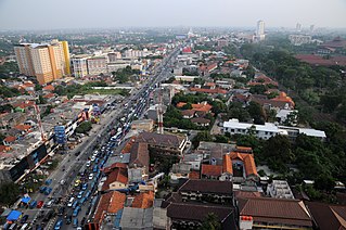
Depok is a landlocked city in West Java province. It is located directly south of Jakarta, it is the third largest urban centre in the Greater Jakarta metropolitan area after Jakarta and Bekasi and it has an area of 199.91 km2. It had a population of 1,738,600 at the 2010 census and 2,056,400 at the 2020 census; the official estimate as at mid 2023 was 2,145,400, resulting in a density of 10,731.8 people per km2. Depok was created as a separate city on 20 April 1999, having previously been part of Bogor Regency. It constitutes the second most populous suburban city in Indonesia, and the tenth most populous suburban city globally.
East Jakarta is the largest of the five administrative cities which form the Special Capital Region of Jakarta, Indonesia, with a land area of 188.03 km2. It had a population of 2,693,896 at the 2010 Census and 3,037,139 at the 2020 Census; the official estimate as at mid 2023 was 3,315,114, making it the most populous of the five administrative cities within Jakarta. East Jakarta is not self-governed and does not have a city council, hence it is not classified as a proper municipality.

South Jakarta, abbreviated as Jaksel, is one of the five administrative cities which form the Special Capital Region of Jakarta, Indonesia. South Jakarta is not self-governed and does not have a city council, hence it is not classified as a proper municipality. It covers a land area of 141.27 km2, and had a population of 2,062,232 at the 2010 census and 2,226,812 at the 2020 census, and 2,409,380 as at mid 2022 according to the official estimates. It is the third most populous among the five administrative cities of Jakarta, after East Jakarta and West Jakarta. The administrative centre is at Kebayoran Baru.
Cinere is a town and an administrative district (kecamatan) of the city of Depok, in West Java Province of Indonesia. It covers an area of 10.53 km2 and had a population of 107,461 at the 2010 Census and 101,700 at the 2020 Census; the official estimate was 101,600. Cinere District borders to its east on the Jagakarsa District and to its north on the Cilandak District, both being part of South Jakarta City; to the west it borders on the Ciputat Timur District and the Pamulang District of South Tangerang City within Banten Province; and to the south it borders on the Limo District of Depok City. Cinere has a large multi-racial population as a result of long-term transmigration from elsewhere in West Java and from Banten, which began in the late 1960s.

Bulungan Regency is a regency of North Kalimantan Province in Indonesia. It covers an area of 13,181.92 km2 and had a population of 112,663 at the 2010 Census and 151,844 at the 2020 Census; the official estimate as at mid 2023 was 165,775. The administrative centre is at Tanjung Selor.

Magelang is a regency in Central Java, Indonesia, famous for its 9th century Buddhist temple of Borobudur. Its capital is Mungkid. It covers an area of 1,085.73 km2 and had a population of 1,181,723 at the 2010 Census and 1,299,859 at the 2020 Census; the official estimate as at mid 2023 was 1,330,656. These figures exclude the autonomous city of Magelang, which is separately administered but is geographically enclaved within the regency, which borders Temanggung Regency to the north, Semarang Regency to the northeast, Boyolali Regency to the east, the Special Region of Yogyakarta to the south and southeast, Purworejo Regency to the southwest, and Wonosobo Regency to the west.

Bogor Regency is a landlocked regency (kabupaten) of West Java province in Indonesia, situated south of DKI Jakarta. Covering an area of 2,991.78 km2, it is considered a bedroom community for Jakarta, and was home to 5,427,068 people at the 2020 census. The official estimate as at mid 2023 was 5,627,071. The town of Cibinong serves as the regency seat.

Sorong Regency is a regency of the Southwest Papua province of Indonesia. It covers an area of 13,075.28 km2, and had a population of 70,619 at the 2010 Census, and 118,679 at the 2020 Census; the official estimate as of mid-2023 was 129,963. Its administrative centre is the town of Aimas. Sorong Regency surrounds Sorong City (Kota) on the landward side; the city is administratively independent of the Regency and is not included in the above statistics; Sorong City has an airport, Sorong Airport, which also serves the Regency.

Central Tapanuli Regency is a regency in North Sumatra province, Sumatra, Indonesia. The seat of the regency government is at Pandan. The regency covers an area of 2,194.98 km2 and consists of a long extent of land along the western coast of North Sumatra, together with offshore islands of which the largest is Mursala Island; it had a population of 311,232 at the 2010 census and 365,177 at the 2020 Census; the official estimate as at mid-2023 was 386,895. The regency surrounds the landward side of the city of Sibolga, which is administratively separate from the regency.

Cimanggis is an administrative district (kecamatan) within the city of Depok, in the province of West Java, Indonesia. Cimanggis is located in the north of Depok, immediately south of Jakarta. It covers an area of 21.78 km2 and had a population of 241,979 at the 2010 Census and 252,000 at the 2020 Census; the latest official estimate is 252,370.
Sawangan is a town and an administrative district in the city of Depok, in West Java province of Indonesia. It covers an area of 26.07 km2 and had a population of 123,571 at the 2010 census and 178,900 at the 2020 Census; the latest official estimate is 197,170.

Pesisir Barat Regency is a regency in Lampung Province of Indonesia. It was created on 25 October 2012 from the eight western districts of West Lampung Regency. It covers an area of 2,907.23 km2, and had a population of 141,741 at the 2010 Census and 162,697 at the 2020 Census; the official estimate as of mid-2023 was 174,695. The administrative center is the town of Krui. The majority group in the Pesisir Barat Regency is the Lampung people, while the Bengkulu language is also spoken in some districts.

Beji is a town and an administrative district (kecamatan) within the city of Depok, in the province of West Java, Indonesia, within the Jakarta metropolitan area. It covers an area of 14.56 km2 and had a population of 165,903 at the 2010 Census and 171,700 at the 2020 Census; the official estimate as at mid 2023 is 171,660. The University of Indonesia, Gunadarma University, Bina Sarana Informatika and Jakarta State Polytechnic are located in this area.
Serpong is a town and an administrative district (kecamatan) of South Tangerang city, in Banten Province on Java, Indonesia. Before South Tangerang City became an autonomous city, Serpong District was one of the districts of Tangerang Regency. It covers an area of 28.27 km2, and had a population of 137,212 at the 2010 Census and 154,744 at the 2020 Census; the official estimate as at mid 2023 was 163,451. The district is sub-divided into nine kelurahan.
Pancoran Mas is a town and an administrative district (kecamatan) within the city of Depok, in the province of West Java, Indonesia. It covers an area of 18.05 km2 and had a population of 210,514 at the 2010 Census and 245,000 at the 2020 Census; the latest official estimate is 253,360.
Limo is a town and an administrative district (kecamatan) within the city of Depok, in the province of West Java, Indonesia. It covers an area of 11.89 km2 and had a population of 87,953 at the 2010 Census and 115,700 at the 2020 Census; the latest official estimate is 124,020.
Cipayung is a town and an administrative district (kecamatan) within the city of Depok, in the province of West Java, Indonesia. It covers an area of 11.375 km2 and had a population of 127,917 at the 2010 Census and 171,600 at the 2020 Census; the latest official estimate is 184,930.
Cilodong is a town and an administrative district (kecamatan) within the city of Depok, in the province of West Java, Indonesia. It covers an area of 15.38 km2 and had a population of 125,014 at the 2010 Census and 168,200 at the 2020 Census; the latest official estimate is 181,410.
Tapos is a town and an administrative district (kecamatan) within the city of Depok, in the province of West Java, Indonesia. It covers an area of 33.43 km2 and had a population of 216,215 at the 2010 Census and 263,400 at the 2020 Census; the latest official estimate is 276,010.
Bojongsari is a town and an administrative district (kecamatan) within the city of Depok, in the province of West Java, Indonesia. It covers an area of 19.41 km2 and had a population of 99,735 at the 2010 Census and 135,700 at the 2020 Census; the latest official estimate is 146,810.


