Related Research Articles

Zitácuaro, officially known as Heroica Zitácuaro, is a city in the Mexican state of Michoacán. The city is the administrative centre for the surrounding municipality of the same name, which lies at the extreme eastern side of Michoacán and borders on the adjacent state of México. The city reported a population of 185,534 in the 2010 census. The municipality has an area of 498 km2. The name Zitácuaro comes from Mazahua Tsitákuarhu.
Tingüindín is a municipality in the Mexican state of Michoacán. The municipality has an area of 174.24 square kilometres and is bordered to the north by the municipalities of Villamar, Tangamandapio and Tangancícuaro, to the east by Los Reyes, and to the south and west by Tocumbo. The municipality had a population of 12,414 inhabitants according to the 2005 census. Its municipal seat is the city of the same name.
Tingambato is a municipality in the Mexican state of Michoacán. Its municipal seat is the city of the same name. The municipality has an area of 188.77 square kilometres and is bordered by the north by the municipalities of Nahuatzén and Erongarícuaro, to the east by Pátzcuaro and Salvador Escalante, to the south by Ziracuaretiro, and to the west by Uruapan. The municipality had a population of 17,630 inhabitants according to the 2015 census. Its municipal seat is the city of the same name.
Tarímbaro is a is a municipality in the Mexican state of Michoacán. The municipality has an area of 258.57 square kilometres and is bordered to the north by Copándaro, Meson Nuevo and Cuitzeo, to the east by Álvaro Obregón, to the south by Morelia and Charo, and to the west by Chucándiro. The municipality had a population of 51,479 inhabitants according to the 2005 census. Its municipal seat is the city of the same name.
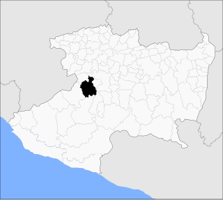
Copándaro is a municipality in the Mexican state of Michoacán. The municipality has an area of 173.52 square kilometres and is bordered to the north by Huandacareo and Cuitzeo, to the east and south by Tarímbaro, and to the west by Chucándiro. The municipality had a population of 8,131 inhabitants according to the 2005 census. Its municipal seat is the city of Copándaro de Galeana.
Tiquicheo de Nicolás Romero is a municipality in the Mexican state of Michoacán. The municipality has an area of 1,429.65 square kilometres and is bordered to the north by the municipality of Tzitzio, to the east by Tuzantla and the state of México, to the south by San Lucas, Huetamo and the state of Guerrero, and to the west by Carácuaro and Madero. The municipality had a population of 13,665 inhabitants according to the 2005 census. Its municipal seat is the city of Tiquicheo.
Tuzantla is a municipality in the eastern part of the Mexican state of Michoacán. The municipality has an area of 1,018.49 square kilometres and is bordered to the north by the municipalities of Jungapeo and Hidalgo, to the east by Juárez and Susupuato, to the south by Tiquicheo and the state of Guerrero, and to the west by Tiquicheo and Tzitzio. The municipality had a population of 15,302 inhabitants according to the 2005 census. Its municipal seat is the city of the same name.
Jungapeo is a municipality in the eastern part of the Mexican state of Michoacán. The municipality has an area of 265.98 square kilometres and is bordered to the north by the municipality of Tuxpan, to the east by Juárez and Zitácuaro, to the south by Tuzantla, and to the west by Hildago. The municipality had a population of 18,571 inhabitants according to the 2005 census. Its municipal seat is the city of Jungapeo de Juárez.
Juárez is a municipality in the Mexican state of Michoacán. The municipality has an area of 141.21 square kilometres and is bordered to the north by the municipality of Zitácuaro, to the east and south Susupuato, and to the west by Tuzantla and Jungapeo. The municipality had a population of 12, 016 inhabitants according to the 2005 census. Its municipal seat is the city of Benito Juárez.
Nuevo Urecho is a municipality located in the center of the Mexican state of Michoacán. The municipality has an area of 330.66 square kilometres and is bordered to the north by the municipality of Taretan, to the east by Ario, to the south by La Huacana, and to the west by Gabriel Zamora. The municipality had a population of 7,722 inhabitants according to the 2005 census. Its municipal seat is the city of the same name.
Taretan is a municipality located in the central part of the Mexican state of Michoacán. The municipality has an area of 185.23 square kilometres and is bordered to the north by the municipality of Ziracuaretiro, to the east by Salvador Escalante and Ario, to the south by Gabriel Zamora and Nuevo Urecho, and to the west by Uruapan The municipality had a population of 12,294 inhabitants according to the 2005 census. Its municipal seat is the city of the same name.
Gabriel Zamora is a municipality in the center of the Mexican square kilometres and is bordered to the north by the municipalities of Nuevo Parangaricutiro, Uruapan and Taretan, to the east by Nuevo Urecho, to the south by Múgica, and to the west by Parácuaro. The municipality had a population of 19,876 inhabitants according to the 2005 census. Its municipal seat is the city of Lombardía.
Tumbiscatío is a municipality in the southwest region of the Mexican state of Michoacán. The municipality has an area of 2,069.48 square kilometres and is bordered to the north by the municipalities of Apatzingán and La Huacana, to the east and south by Arteaga, to the southwest by Coalcomán de Vázquez Pallares, and to the west by Aguililla. The municipality had a population of 8,373 inhabitants according to the 2005 census. Its municipal seat is the city of Tumbiscatío de Ruiz.
Coalcomán de Vázquez Pallares is a municipality located in the Sierra Madre del Sur mountain range, in the southwest region of the state of Michoacán in central-western Mexico.
Chinicuila is a municipality located in the southwestern region of the Mexican state of Michoacán. The municipality has an area of 928.64 square kilometres and is bordered to the north by the state of Jalisco, to the east by Coalcomán, to the south by Aquila, and to the west by Coahuayana and the state of Colima. The municipality had a population of 5,343 inhabitants according to the 2005 census. Its municipal seat is the city of Villa Victoria.
Coahuayana is a municipality in the Mexican state of Michoacán. The municipality has an area of 362.34 square kilometres and is bordered to the north by the municipality of Chinicuila, to the south by Aquila and the Pacific Ocean, and to the west and northwest by the state of Colima. The municipality had a population of 11,632 inhabitants according to the 2005 census. Its municipal seat is the city of the same name.
Tancítaro is a city and municipality in the western part of the Mexican state of Michoacán, in Southwestern Mexico. Its municipal seat is the City of Tancítaro.
Peribán is a municipality in the Mexican state of Michoacán. The municipality has an area of 331.87 square kilometres and is bordered to the north by the municipality of Los Reyes, to the east by Uruapan, to the southeast by Tancítaro, to the south by Buenavista, and to the west by the state of Jalisco. The municipality had a population of 20,965 inhabitants according to the 2005 census. Its municipal seat is the city of Peribán de Ramos.
Los Reyes is a municipality in the Mexican state of Michoacán. The municipality has an area of 480.09 square kilometres and is bordered to the north by the municipality of Tangancícuaro, to the east by Charapan, to the southeast by Uruapan, to the south by Peribán, to the southwest by Tocumbo, and to the northwest by Tingüindín. The municipality had a population of 77,000 inhabitants according to the 2009 census. Its municipal seat is the city of Los Reyes de Salgado.The city is also known for exporting avocados and blackberries. Both of these orchids surround the area between Los Reyes and Periban, it is also home of the Lobos Grises de los Reyes a professional soccer team currently playing in the Tercera Division Mexicana at Group IX.
Charapan is a municipality located in the north-western part of the Mexican state of Michoacán. The municipality has an area of 233.16 square kilometres and is bordered to the north by the municipalities of Tangancícuaro and Chilchota, to the east by Paracho, to the south by Uruapan, and to the west by Los Reyes. The municipality had a population of 10,867 inhabitants according to the 2005 census. Its municipal seat is the city of the same name.
References
- ↑ Michoacán Archived 2011-05-17 at the Wayback Machine Enciclopedia de los Municipios de México. Retrieved on October 6, 2007
- ↑ "2005 Census". INEGI: Instituto Nacional de Estadística, Geografía e Informática. Archived from the original on 2013-04-06. Retrieved 2007-10-06.
19°13′N100°24′W / 19.217°N 100.400°W

| International | |
|---|---|
| National | |
| | This article about a location in the Mexican state of Michoacán is a stub. You can help Wikipedia by expanding it. |