Michoacán, formally Michoacán de Ocampo, officially the Estado Libre y Soberano de Michoacán de Ocampo, is one of the 31 states which, together with Mexico City, comprise the Federal Entities of Mexico. The state is divided into 113 municipalities and its capital city is Morelia. The city was named after José María Morelos, a native of the city and one of the main heroes of the Mexican War of Independence.

Morelia is a city and municipal seat of the municipality of Morelia in the north-central part of the state of Michoacán in central Mexico. The city is in the Guayangareo Valley and is the capital and largest city of the state. The main pre-Hispanic cultures here were the Purépecha and the Matlatzinca, but no major cities were founded in the valley during this time. The Spanish took control of the area in the 1520s. The Spanish under Viceroy Antonio de Mendoza founded a settlement here in 1541 with the name of Valladolid, which became rival to the nearby city of Pátzcuaro for dominance in Michoacán. In 1580, this rivalry ended in Valladolid's favor, and it became the capital of the viceregal province. After the Mexican War of Independence, the city was renamed Morelia in honor of José María Morelos, who hailed from the city. In 1991, the city was declared a UNESCO World Heritage Site for its well-preserved historical buildings and layout of the historic center. It is tradition to name people born on September 30 after the city.

Zitácuaro, officially known as Heroica Zitácuaro, is a city in the Mexican state of Michoacán. The city is the administrative centre for the surrounding municipality of the same name, which lies at the extreme eastern side of Michoacán and borders on the adjacent state of México. The city reported a population of 185,534 in the 2010 census. The municipality has an area of 498 km2. The name Zitácuaro comes from Mazahua Tsitákuarhu.
Uruapan is the second largest city in the Mexican state of Michoacán. It is located at the western edge of the Purépecha highlands, just to the east of the Tierra Caliente region. Since the colonial period, it has been an important city economically due its location. The city was conquered by the Spanish in 1522, when the last Purépecha ruler fled the Pátzcuaro area to here. The modern city was laid out in 1534 by Friar Juan de San Miguel. It played an important role in the War of Independence, and was the capital of Michoacán during the French Intervention. Today it is the center of Mexico's avocado growing region, with most of the crop distributed from here nationally and internationally.

Zamora de Hidalgo(Spanish pronunciation: [saˈmoɾa de i'dalɢo]) is a city in the Mexican state of Michoacán. The 2010 census population was 141,627. making it the third largest city in the state. The city is the municipal seat of Zamora Municipality, which has an area of 330.97 km2 and includes many other smaller communities, the largest of which is Ario de Rayón. The municipality's population is around 186,102, which makes it the second most populous urban area in the state.

Ciudad Hidalgo, or simply Hidalgo, is a city and municipal seat of the Municipality of Hidalgo in the far northeast of the state of Michoacán, Mexico. It is a city located in a rural, mountainous area. While most of the city consists of modern buildings, its principal monument is the 16th-century church and former monastery of San José. Formerly, its name was Taximaroa, and it was the part of the Purépecha Empire closest to the Aztec Empire. This prompted two unsuccessful Aztec invasions as well as the first Spanish incursion into Purépecha lands in 1522. For both the city and rural communities around it, forestry and furniture making are important parts of the economy, but deforestation is forcing the area to look into alternatives such as tourism to take advantage of its natural resources and cultural sites.
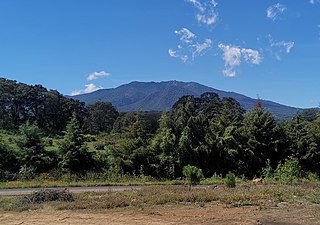
Aporo is a municipality in the Mexican state of Michoacán. The municipal seat is the town of Aporo. Most of the municipality is forested and considered to be part of Monarch Butterfly Biosphere Reserve, where millions of monarch butterflies arrive to stay five months each winter. The town and municipality have mostly adobe structures with tile roofs and the main architectural site is the San Lucas Evangelista Church, which was built in the 20th century.
Churumuco is a municipality located in the southeastern part of the Mexican state of Michoacán. The municipality has an area of 1,119.44 square kilometres and is bordered to the north by the municipality of La Huacana, to the northeast by Turicato, to the south by the state of Guerrero, to the southwest by Huetamo, and to the west by Arteaga. The municipality had a population of 13,801 inhabitants according to the 2005 census.
Jiquipilco Municipality is one of the municipalities of the State of Mexico in Mexico. It is north of the Toluca Valley, part of the region consisting of the southern and western slopes of Cerro La Catedral, which has a concentration of speakers of the Otomi language. It is about 40 km from Toluca, the state capital. The name is a corruption of Nahuatl “Xiquipilco”, meaning “in the saddlebags”. Jiquipilco is situated on the transversal volcanic axis that crosses Mexico in an area surrounded by lakes and volcanoes. This portion is called "Anahuac”.

Huandacareo is a municipality in the north of the Mexican state of Michoacán, on the northwest side of Lake Cuitzeo. The municipal seat is the town of Huandacareo. It is a small rural community located 48 km north of the state capital of Morelia. The area was part of the Tarascan state during the pre Hispanic period, then came under the control of the Augustinians. It was part of the territory of neighboring Cuitzeo until 1919, when it became an independent municipality. Its economic base from the colonial period to the present has been agriculture, growing corn, other crops, pigs and domestic fowl. There is also some tourism, mostly to the municipality's two archeological sites and its colonial churches.
La Huacana is the municipal seat of La Huacana Municipality in Michoacán, Mexico. In 2010 it also was the most populous locality in the municipality. It is located 161 kilometers from the state capital Morelia.

Zinapécuaro is a municipality in the Mexican state of Michoacán, located 50 kilometres (31 mi) northeast of the state capital Morelia.
Carácuaro is a municipality in the Mexican state of Michoacán, located 77 kilometres (48 mi) south of the state capital of Morelia.
Contepec is a municipality in the Mexican state of Michoacán, located 110 kilometres (68 mi) east of the state capital of Morelia.
Huaniqueo is a municipality in the Mexican state of Michoacán. It is located approximately 40 kilometres (25 mi) northwest of the state capital of Morelia.
Nocupétaro is a municipality in the Mexican state of Michoacán. It is located approximately 75 kilometres (47 mi) south of the state capital of Morelia.

Senguio is a municipality in the Mexican state of Michoacán. It is located approximately 90 kilometres (56 mi) east of the state capital of Morelia.

Tzitzio is a municipality in the Mexican state of Michoacán, located approximately 30 kilometres (19 mi) southeast of the state capital of Morelia.

Zinapécuaro de Figueroa is a town and the seat of the municipality of Zinapécuaro, in the central Mexican state of Michoacán.