Sveta Nedjelja, Hvar

Last updated
Sveta Nedjelja
Sveta Nedija
Sveta Nedilja
Village
Crkva u sv. Nedilji na Hvaru.jpg
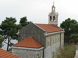
Church of Sveta Nedilja
Croatia location map.svg
Red pog.svg
Sveta Nedjelja
Location of Sveta Nedjelja
Coordinates: 43°08′10″N16°35′20″E / 43.13611°N 16.58889°E / 43.13611; 16.58889
CountryFlag of Croatia.svg  Croatia
County Split-Dalmatia
Town Hvar
Area
[1]
  Total4.6 km2 (1.8 sq mi)
Population
 (2021) [2]
  Total135
  Density29/km2 (76/sq mi)
Time zone UTC+1 (CET)
  Summer (DST) UTC+2 (CEST)
Postal code
21465
Area code +385 (0)21

Sveta Nedjelja [3] also known as Sveta Nedilja (Chakavian dialect: Sveta Nedija), is a small village on the Croatian island of Hvar. It is located near the town of Hvar and it has 131 residents (2011). [4]

Contents

History

Sveta Nedjelja lies on a sheer cliff at the foot of Sv. Nikola (St. Nicholas; 626 metres) the highest peak of the island, below a cave which was inhabited back in the Neolithic.

The cave served as the site for an Augustinian monastery in the Middle Ages. The monastery, which existed from the 15th century to 1787, was built in a large opening of the cave where there is also a spring. Today, only the monastery church and a part of a shell of a house are preserved.

The village, which lies half way to the cave, is reached from the sea by a winding path which snakes up through pine woods. A new church was built in the village this century. It has a painting "St. Jerome and the Saints" by Baldassare d'Anna, and a crucifix by Juraj Plančić (1899–1930).

Wine tradition

Sveta Nedjelja is well known for its wine tradition. Vineyards are located on steep south slopes above the village. Wine from this region is characterized by a strong red color and fullness of flavor. Plavac Mali is the most typical red wine grape variety. [5] It is also a hometown of a famous Zlatan Otok winery established in 1986 by Zlatan Plenković. [6]

Related Research Articles

<span class="mw-page-title-main">Hvar</span> Island in Croatia

Hvar is a Croatian island in the Adriatic Sea, located off the Dalmatian coast, lying between the islands of Brač, Vis and Korčula. Approximately 68 km (42.25 mi) long, with a high east–west ridge of Mesozoic limestone and dolomite, the island of Hvar is unusual in the area for having a large fertile coastal plain, and fresh water springs. Its hillsides are covered in pine forests, with vineyards, olive groves, fruit orchards and lavender fields in the agricultural areas. The climate is characterized by mild winters, and warm summers with many hours of sunshine. The island has 10,678 residents according to the 2021 census, making it the 4th most populated of the Croatian islands.

<span class="mw-page-title-main">Otok, Vukovar-Syrmia County</span> Town in Slavonia, Croatia

Otok is a town in eastern Croatia, located 20 km south of Vinkovci, in eastern Slavonia. The settlement gained the status of town by the decision of the Parliament of Croatia on July 13, 2006. At the time, nearby Privlaka was a part of the municipality, but was subsequently declared a municipality in its own right. The population of the town of Otok is 6,343, with 4,694 residents in Otok itself and 1,649 in the nearby village of Komletinci. In the census of 2011, 99.31% of the population declared themselves Croats.

<span class="mw-page-title-main">Rudina, Croatia</span> Village on the island of Hvar in Croatia

Rudina is a small village on the island of Hvar, in the Adriatic Sea in Croatia. It is located near Stari Grad. The village has a population of 70 people. Most of the population are fishermen. There is a lagoon, Žukova, located there. Rudina has become an escape for the art community during the summer months.

<span class="mw-page-title-main">Sućuraj</span> Municipality in Split-Dalmatia County, Croatia

Sućuraj is the smallest town on the island of Hvar in the Croatian part of the Adriatic Sea, 3 NM (5 km) from the Dalmatian coast and 77 km from the town of Hvar. Sućuraj has about 400 residents, with tourism and fishing being the primary economic activities. The town is the official centre of the eastern part of the island of Hvar.

<span class="mw-page-title-main">Bol, Croatia</span> Municipality in Split-Dalmatia County, Croatia

Bol is a municipality on the south of the island of Brač in the Split-Dalmatia County of Croatia, population 1,630 (2011).

<span class="mw-page-title-main">Komiža</span> Town in Split-Dalmatia, Croatia

Komiža is a Croatian coastal town lying on the western coast of the island of Vis in the central part of the Adriatic Sea. As of 2011 Komiža proper has a population of 1,397 while the entire municipality has 1,526 residents.

Stari Grad is a town on the northern side of the island of Hvar in Dalmatia, Croatia. One of the oldest towns in Europe, its position at the end of a long, protected bay and next to prime agricultural land has long made it attractive for human settlement. Stari Grad is also a municipality within the Split-Dalmatia County.

<span class="mw-page-title-main">Hvar (town)</span> Town in Split-Dalmatia, Croatia

Hvar is a town and port on the island of Hvar, part of Split-Dalmatia County, Croatia. The municipality has a population of 4,251 (2011) while the town itself is inhabited by 3,771 people, making it the largest settlement on the island of Hvar. It is situated on a bay in the south coast of the island, opposite from the other nearby towns of Stari Grad and Jelsa.

<span class="mw-page-title-main">Sveta Nedelja, Zagreb County</span> Town in Zagreb, Croatia

Sveta Nedelja or, until 1991, Sveta Nedjelja is a town in Zagreb County, Croatia. It is one of the provincial satellite towns in Zagreb's metropolitan region.

<span class="mw-page-title-main">Dugi Otok</span> Long island in the Adriatic sea, part of Croatia

Dugi Otok is the seventh largest island in the Adriatic Sea, part of Croatia. It is located off the Dalmatian coast, west of Zadar. It is the largest and westernmost of the Zadarian Islands, and derives its name from its distinctive shape: it is 44.5 km long by 4.8 km wide, with an area of 114 square kilometres (44 sq mi). Its elevation reaches 300 m; and many of its higher portions contain stands of Maritime Pine.

<span class="mw-page-title-main">Orebić</span> Municipality in Dubrovnik-Neretva County, Croatia

Orebić is a port town and municipality in the Dubrovnik-Neretva county in Croatia. It is located on the Pelješac peninsula on the Dalmatian coast. Orebić is directly across a strait from the town of Korčula, located on the island of the same name. Ferries service the two towns frequently. Orebić is 112 km (70 mi) from Dubrovnik.

Otok is a municipality and a village in inland Dalmatia, Croatia, located east of Sinj, approximately 7 kilometers away. Otok is bordered by the river Cetina and mountain Kamešnica.

<span class="mw-page-title-main">Smokvica, Korčula</span> Municipality in Dubrovnik-Neretva County, Croatia

Smokvica is a village on the island of Korčula and a municipality in the Dubrovnik-Neretva County in Croatia. Smokvica is located in the centre of the island of Korčula, about 4 kilometers west of Čara, 13 kilometers east of Blato and 4 kilometers north from Brna. It is known as the birthplace of one of the best-known Croatian wines - Pošip.

<span class="mw-page-title-main">Jelsa, Croatia</span> Municipality in Split-Dalmatia County, Croatia

Jelsa is a town in Croatia, on the island of Hvar, the seat of the eponymous municipality (općina) within the county of Split-Dalmatia.

<span class="mw-page-title-main">Vrboska</span> Town in Split-Dalmatia County, Croatia

Vrboska is a settlement on the north coast of the island of Hvar in Dalmatia, Croatia, in the Municipality of Jelsa. Founded in the 15th century as a fishing harbour, the town's fortress Church of Sv. Marija was built as a refuge for its inhabitants during the 16th century. Vrboska has a population of 548 at the 2011 census.

Dragove is a village in the north-eastern part of the island of Dugi Otok in Zadar County, Croatia. Dragove is located on the regional road running along the entire island. The population is 35.

<span class="mw-page-title-main">Drašnice</span> Village in Croatia

Drašnice is a tourist locality in southern Dalmatia, Croatia, located between Makarska and Ploče. The population is 339 (2011).

<span class="mw-page-title-main">Slatine</span> Place in Split-Dalmatia, Croatia

Slatine is a village on Čiovo, an island in Split-Dalmatia County, Croatia. It is a small fishing and tourist village situated on the northeastern side of the island Čiovo, only 8 km from Trogir. It lies on the coast of Kaštela bay, opposite Split and peninsula Marjan, which are to the east. There are 1,106 inhabitants in the settlement.

<span class="mw-page-title-main">Humac, Hvar</span> Village in Croatia

Humac is an uninhabited hamlet on the island of Hvar, Croatia. It is connected by the D116 highway. Located 350 m (1,150 ft) above sea level, 10 km (6.2 mi) from Jelsa.

<span class="mw-page-title-main">Pitve</span> Village in Split-Dalmatia County, Croatia

Pitve is a settlement on the island of Hvar, in the district of Jelsa. It lies 168 metres above sea-level on the northern side of the island, in the hills above Jelsa.

References

  1. Register of spatial units of the State Geodetic Administration of the Republic of Croatia. Wikidata   Q119585703.
  2. "Population by Age and Sex, by Settlements, 2021 Census". Census of Population, Households and Dwellings in 2021. Zagreb: Croatian Bureau of Statistics. 2022.
  3. "Zakon o područjima županija, gradova i općina u Republici Hrvatskoj" [Law on the Territories of Counties, Cities and Municipalities in the Republic of Croatia] (in Croatian). Retrieved 5 October 2021.
  4. "Census of Population, Households and Dwellings 2011". Republic of Croatia: Central Bureau of Statistics. Retrieved 3 August 2015.
  5. "Wine Region". Zlatan Otok.
  6. "Vineyards and Winery". Zlatan Otok.