Vrboska

Last updated

Vrboska
Town
Vrboska, island and church of St Mary of Grace.jpg
Vrboska center, with St Mary's Church
Croatia location map.svg
Red pog.svg
Vrboska
Location of Vrboska within Croatia
Coordinates: 43°10′N16°27′E / 43.167°N 16.450°E / 43.167; 16.450
Country Croatia
County Split-Dalmatia County
Municipality Jelsa
Area
[1]
  Total7.5 km2 (2.9 sq mi)
Elevation
0 m (0 ft)
Population
 (2021) [2]
  Total542
  Density72/km2 (190/sq mi)
Time zone UTC+1 (CET)
  Summer (DST) UTC+2 (CEST)
Postal code
21463 Vrboska
Area code +385 (0)21
Website www.vrboska.info
Islet in the Bay of Vrboska Islet in the bay of Vrboska.jpg
Islet in the Bay of Vrboska
Boats in the Canal of Vrboska Boats in the canal of Vrboska.jpg
Boats in the Canal of Vrboska
Bridges and canal of Vrboska Bridges and canal of Vrboska.jpg
Bridges and canal of Vrboska
St Marys Church Fortress in Vrboska Church (fortress) of St. Mary of Grace, Vrboska.jpg
St Marys Church Fortress in Vrboska

Vrboska is a settlement on the north coast of the island of Hvar in Dalmatia, Croatia, in the Municipality of Jelsa. Founded in the 15th century as a fishing harbour, the town's fortress Church of Sv. Marija (St Mary) was built as a refuge for its inhabitants during the 16th century. [3] Vrboska has a population of 548 at the 2011 census. [4]

Contents

Geographical

The town is on the northern coast of the island of Hvar, in a deep narrow bay surrounded by pine forest, vineyards, and olive groves. Vrboska lies on the north-eastern side of the UNESCO protected world heritage site Stari Grad Plain.

Name

The name Vrboska is probably derived from Vrbanj, the inland village whose inhabitants originally used the sheltered inlet as a fishing port.[ citation needed ] Another theory is that it comes from the Latin verboscam, meaning forested. [3]

History

Founded in the Middle Ages, the oldest building is the church of St Peter, which was built before the 14th century between the boundaries of Pitve and Vrbanj. In the immediate vicinity, on the Stari Grad Plain, is the ancient Villa Rustica.

Matija Ivanić, the populist leader of the Hvar Rebellion of 1510-1514, had a house in Vrboska. The Venetian troops attacked the town in 1510, causing extensive damage. In 1571, the town was again attacked, this time by the Turks, under Uluz Ali. Soon afterwards, in 1575, the church of St Mary was fortified, to become a church-fortress, the only such structure in the archipelago.

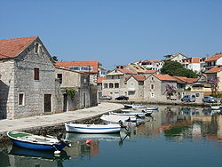
The place developed as a fishing community, trading and growing in prosperity. At the beginning of the 20th century, Vrboska had a sardine factory, wooden boat-building industry, a hotel, fishing trade association, and regular boat connections with Split and the neighbouring island of Brač. There was a community hall, library and health clinic.

Economy

Vrboska today is a tourist destination with a yachting marina.

Culture

The church of St. Mary of Mercy was re-built in the shape of a fortress around 1575 following the Turkish attack on the older church from 1465. The parish church of St. Lovrinac was built in 1571, and restored in the 17th century. The main altar of St. Lovrinac has a Paola Veronesca, and work of John Rendic. There are also paintings by the Venetian Masters: Tizian, Cagaliarija, Bassano, Scuria, Cellinia and others. The church of St. Peter, mentioned in 1331, was a border point between the territory of neighbouring villages Pitve and Vrbanj, even before the founding of Vrboska. Restored in 1469 it is considered one of the oldest religious buildings on the island.

The patron saint of Vrboska is St Lovrinac.

Related Research Articles

<span class="mw-page-title-main">Senj</span> Town in Lika-Senj, Croatia

Senj is a town on the upper Adriatic coast in Croatia, in the foothills of the Mala Kapela and Velebit mountains.

<span class="mw-page-title-main">Makarska</span> City in Split-Dalmatia, Croatia

Makarska is a town on the Adriatic coastline of Croatia, about 60 km (37 mi) southeast of Split and 140 km (87 mi) northwest of Dubrovnik, in the Split-Dalmatia County.

<span class="mw-page-title-main">Hvar</span> Island in Croatia

Hvar is a Croatian island in the Adriatic Sea, located off the Dalmatian coast, lying between the islands of Brač, Vis and Korčula. Approximately 68 km (42.25 mi) long, with a high east–west ridge of Mesozoic limestone and dolomite, the island of Hvar is unusual in the area for having a large fertile coastal plain, and fresh water springs. Its hillsides are covered in pine forests, with vineyards, olive groves, fruit orchards and lavender fields in the agricultural areas. The climate is characterized by mild winters, and warm summers with many hours of sunshine. The island has 10,678 residents according to the 2021 census, making it the 4th most populated of the Croatian islands.

<span class="mw-page-title-main">Sućuraj</span> Municipality in Split-Dalmatia County, Croatia

Sućuraj is the smallest town on the island of Hvar in the Croatian part of the Adriatic Sea, 3 NM (5 km) from the Dalmatian coast and 77 km from the town of Hvar. Sućuraj has about 400 residents, with tourism and fishing being the primary economic activities. The town is the official centre of the eastern part of the island of Hvar.

<span class="mw-page-title-main">Komiža</span> Town in Split-Dalmatia, Croatia

Komiža is a Croatian coastal town lying on the western coast of the island of Vis in the central part of the Adriatic Sea. As of 2011 Komiža proper has a population of 1,397 while the entire municipality has 1,526 residents.

Stari Grad is a town on the northern side of the island of Hvar in Dalmatia, Croatia. One of the oldest towns in Europe, its position at the end of a long, protected bay and next to prime agricultural land has long made it attractive for human settlement. Stari Grad is also a municipality within the Split-Dalmatia County.

<span class="mw-page-title-main">Hvar (town)</span> Town in Split-Dalmatia, Croatia

Hvar is a town and port on the island of Hvar, part of Split-Dalmatia County, Croatia. The municipality has a population of 4,251 (2011) while the town itself is inhabited by 3,771 people, making it the largest settlement on the island of Hvar. It is situated on a bay in the south coast of the island, opposite from the other nearby towns of Stari Grad and Jelsa.

<span class="mw-page-title-main">Hrvatska Kostajnica</span> Town in Continental Croatia, Croatia

Hrvatska Kostajnica, often just Kostajnica, is a small town in central Croatia. It is located on the Una river in the Sisak-Moslavina County, south of Petrinja and Sisak and across the river from Kostajnica in Bosnia and Herzegovina. In the past, Hrvatska Kostajnica was called by different names, Koztainicha, Kaztanicha to Costgnanica. The name most likely comes from the word Kostanj (chestnut).

<span class="mw-page-title-main">Orebić</span> Municipality in Dubrovnik-Neretva County, Croatia

Orebić is a port town and municipality in the Dubrovnik-Neretva county in Croatia. It is located on the Pelješac peninsula on the Dalmatian coast. Orebić is directly across a strait from the town of Korčula, located on the island of the same name. Ferries service the two towns frequently. Orebić is 112 km (70 mi) from Dubrovnik.

<span class="mw-page-title-main">Molat</span>

Molat is a Croatian island in the Adriatic Sea. It is situated near Zadar, southeast from Ist, separated by Zapuntel strait. It has area of 22.82 km2 (8.81 sq mi).

<span class="mw-page-title-main">Perušić</span> Municipality in Lika-Senj, Croatia

Perušić is municipality (općina) in Lika-Senj County, Croatia. The municipality has 2,638 inhabitants, while the settlement itself has 852. The municipality is within the mountainous Lika region of central Croatia. The Kosinj valley region sprawls alongside it.

<span class="mw-page-title-main">Jelsa, Croatia</span> Municipality in Split-Dalmatia County, Croatia

Jelsa is a town in Croatia, on the island of Hvar, the seat of the eponymous municipality (općina) within the county of Split-Dalmatia.

<span class="mw-page-title-main">Pučišća</span> Municipality in Split-Dalmatia County, Croatia

Pučišća is a coastal town and a municipality on the island of Brač in Croatia. It is often listed as one of the prettiest villages in Europe. It is known for its white limestone and beautiful bay. The town has a population of 1,351.

<span class="mw-page-title-main">Veli Lošinj</span> Village in Primorje-Gorski Kotar, Croatia

Veli Lošinj is a village on the island of Lošinj in Primorje-Gorski Kotar County in western Croatia. Veli Lošinj has a mild climate and caters to tourists. It is located 5 km to the southeast of the town of Mali Lošinj, of which it is part administratively. It was an important port and fishing centre until the late 19th century. Today it is known as a tourist and aromatherapy centre. As of 2021, Veli Lošinj had a population of 857

<span class="mw-page-title-main">Tvrdalj Castle</span>

Tvrdalj Castle is a castle in Stari Grad, on the island of Hvar, Croatia.

<span class="mw-page-title-main">Humac, Hvar</span> Village in Croatia

Humac is an uninhabited hamlet on the island of Hvar, Croatia. It is connected by the D116 highway. Located 350 m (1,150 ft) above sea level, 10 km (6.2 mi) from Jelsa.

<span class="mw-page-title-main">Za križen</span>

Za križen is a night procession that happens every Maundy Thursday on the island of Hvar, Croatia. The event has centuries of tradition and is included in the UNESCO Intangible Cultural Heritage Lists.

<span class="mw-page-title-main">Church of St. Stephen (Stari Grad, Hvar)</span> Church building in Stari Grad, Croatia

The Church of St. Stephen is the parish church of Stari Grad on the island of Hvar in Croatia. It is dedicated to the martyred Pope Stephen I. It stands on the eastern side of a small square, Trg sv. Stjepana, in the historical centre of Stari Grad.

<span class="mw-page-title-main">Pitve</span> Village in Split-Dalmatia County, Croatia

Pitve is a settlement on the island of Hvar, in the district of Jelsa. It lies 168 metres above sea-level on the northern side of the island, in the hills above Jelsa.

References

  1. Register of spatial units of the State Geodetic Administration of the Republic of Croatia. Wikidata   Q119585703.
  2. "Population by Age and Sex, by Settlements, 2021 Census". Census of Population, Households and Dwellings in 2021. Zagreb: Croatian Bureau of Statistics. 2022.
  3. 1 2 Novak, Grga (1960) [1924], Hvar Kroz Stoljeća (Hvar Through the Centuries), Historijski Arhiv - Hvar (Historical Archives of Hvar) (in Croatian), vol. I (2nd ed.), Narodni Odbor Općine Hvar (National Council of Hvar Municipality)
  4. "Population by Age and Sex, by Settlements, 2011 Census: Vrboska". Census of Population, Households and Dwellings 2011. Zagreb: Croatian Bureau of Statistics. December 2012.

Further reading