The Swan View Tunnel is a former railway tunnel located on the southern side of the Jane Brook valley in the outer Perth suburb of Swan View in the John Forrest National Park on the edge of the Darling Scarp. After its closure as a railway tunnel, it reopened as part of the John Forrest Heritage Trail, a rail trail.
Prior to the construction of tunnels and the sinking of the Subiaco railway station in 1999, the Swan View Tunnel was the only tunnel on the Western Australian railway network.
The tunnel was erroneously stated in contemporary reporting to be 13 chains long, which is 261.5184m (858ft).[1] Modern authorities give the length as 340m (1,120ft).[2] Inspection of open source aerial imagery confirms that the tunnel is 340.7 metres (1,118ft) in length.
Initial exploratory surveys of the new Jane Brook deviation were commissioned in 1891 by CY O'Connor. The aim was to find a route over the Darling range to replace the one-in-30 ruling grade existing Eastern Railway section in the Helena Valley.
In 1892, O'Connor recommended to the first Minister for Railways in Western Australia, HW Venn, that a Jane Brook option be selected. His advice was not followed, with an alignment adopted that followed the Jane Brook Valley until a large granite hill was encountered, requiring a drill and blast tunnel to penetrate through the hill. The successful tender for the tunnel construction came from a South Australian firm, Smeaton and Hedges. The tendered price was £47,608, with an expected completion time of 12 months. The engineer in charge of construction was John Muir who had also surveyed the prospective new route, designed the tunnel, and identified that broken rock spoil from the tunnel could be used to create nearby embankments, a prudent move on Muir's part as the principal means of shifting spoil in the 1890s was by draft horse hauling mould board and plough, followed by tipping from horse drawn carts.
Work began in 1894, with tunnelling operations commencing from each end and the two tunnel drives meeting on 18 April 1895.[3] The tunnel opened on 22 February 1896, significantly over-budget and over-schedule.[4][5] The unstable nature of the jointed and sheared granite, along with clay seams, caused difficulties during construction of the tunnel. Multiple rock falls occurred, which required further excavation at considerable cost. Because of the likelihood of further rock falls, the tunnel had to have masonry walls and was fully brick-lined with over 330,000 bricks, increasing construction time and costs and reducing the inner tunnel diameter.
The deviation from the original railway line, and the tunnel in particular, was a "significant technical feat for the time"; Engineers Australia awarded the deviation an Engineering Heritage Marker as part of its Engineering Heritage Recognition Program.[6]
Problems
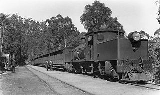
The tunnel was feasible for 1890s style locomotion, with some problems from smell and smoke accumulation, however the advent of larger, more powerful steam locomotives soon exposed the limitations of the tunnel. The tunnel's small diameter combined with the steep gradient (1:49), lack of ventilation shafts and typical requirement for 2 engines to haul heavily laden trains up the steep gradient caused smoke accumulation. Incidents involving near-asphyxiation of train crews started in 1896, and continued throughout the tunnel's operating life. Standard procedure for engine crews was to cover their heads with a water soaked hessian bag and to stay as low as possible on the footplate.[7][8][9] The first serious incident of this nature was in 1903.[10]
The tunnel's design was incompatible with the ASG class Garratt steam locomotives used by the Western Australian Government Railways in the 1940s. The subsequent Royal Commission into the ASG dealt with design of the locomotive, and the very dangerous clearances.[11][12]
Industrial trouble arose in regard to the taking of the ASG locomotives through the Swan View tunnel. This tunnel was constructed many years ago and provides very little clearance for a modern locomotive. In the case of the ASG the distance between the sides and top of the locomotive and the structure of the tunnel is a matter of inches.[13][14]
The worst accident in the tunnel was on 5 November 1942, when both drivers and firemen were overcome by carbon monoxide, one driver dying, when a fully laden double-header train passed through the tunnel at walking pace. A bale of chaff that had been poorly loaded on a previous train had fallen onto the track in the tunnel. When Number 97 goods train from Perth to Northam passed over the bale of chaff, it burst open, distributing chaff over the tracks. When the driving wheels passed over the chaff, the engines lost traction and stalled. The last act of the driver before the crews fell unconscious from smoke and carbon monoxide poisoning was to set the engines into reverse. Consequently the train steamed back down the line and crashed at Swan View Station, with the death of driver Tom Beer.[15][16][17] Further cases occurred in 1943[18] and 1944 on up trains.[19]
Subsequent industrial strikes, a Royal Commission and union agitation for the locomotives' withdrawal was a significant issue in the 1940s.[20][21][22][23]
Deviation
Between 1934 and 1945, a signal cabin was located at Tunnel Junction, on the eastern end of the tunnel, for managing the transition from the tunnel's single line to the dual lines of the system.[24]
The single line tunnel was considered unsafe for eastbound (climbing) trains.[25][26] Following the events of the early 1940's, planning commenced immediately to alleviate the bottleneck caused by the tunnel. Several options were considered, including blasting the top off the tunnel and turning it into a cutting. However it was decided to create a sweeping deviation with a new cutting west of the tunnel, closer to Jane Brook, on the northern side of the hill that the tunnel passed through.
It was known as the Deviation, with construction commencing in 1944, and completion on 28 November 1945. Rockfall problems similar to, if not worse than, those of the tunnel were encountered during construction and severely restricted the subsequent use of the cutting.
"Construction involved a deep cut in granite, some 450 m long, in which protection from rock falls was essential in view of the character of the granite exposed after the cut had been excavated. Steel fences, 2.5 m high with supports 9.9 m apart, were therefore erected on both sides of the cut. The 16 wires forming the fences were in continuous electrical signalling circuits and a simple but effective system of internal electrical interlocking was installed which made the protection system completely automatic. If a wire was broken by falling rock or if a battery or circuit failed, two relays became de-energised, and the signal controlling the line in the cut was placed at danger. An indicator in the Swan Valley signal box showed the operator that a rockfall (or other failure) had occurred. The control signal could only be reset with a special key at the signal itself."[27][5][28] The diversion was completed on 25 November 1945.[29]
Railway closure
The railway line through the tunnel was lifted after the closing of the older and steeper Eastern Railway and the opening of the Avon Valley diversion that opened in February 1966. The new Avon Valley deviation route involved little rock work and flat gradients that had been initially favoured by CY O'Connor.
After the 1960s, gates/doors[which?] were put at either end of the tunnel though these were later removed.[30]
The tunnel remains intact and has reopened as part of the John Forrest Heritage Trail, part of the larger Railway Reserve Heritage Trail.[31] During the 1990s, the government authority in which the tunnel land was vested, the Department of Environment and Conservation allowed a number of night time "ghost walks" in the tunnel as part of the Hills Forest programmes.
Engineering Geology
The tunnel and first open cut deviation are constructed in Archaean meta-granite (slightly altered, coarse-grained granite, in places pegmatitic). This rock mass has been intruded by dolerite dykes which are more deeply weathered than the granites and in places active swelling clay (montmorillonitic) seams have formed.
The main structural problems come from a combination of shears and various types of jointing on the rock mass.
There are 2 sets of sub-vertical conjugate (formed at the same time) shears about 135° apart. These are expressed as bands of closely spaced fractures that have allowed water entry, in some places producing clay seams. In addition there are several types of joints:
(i) sheet joints or stress relief joints, which are continuous and sub-parallel to the topography formed by the erosion of the deep valley adjacent (ii) cooling joints, which are prominent in the intruding dolerite (iii) tectonic joints (iv) blast damage joints (rose of joints) caused by over-blasting
The net result is that a blocky rock mass has been produced with some vertical and sub-horizontal clay seams which allow rock falls, block gliding, rock slides and toppling type failures.
Related Research Articles
John Forrest National Park is a national park in the Darling Scarp, 24 km (15 mi) east of Perth, Western Australia. Proclaimed as a national park in November 1900, it was the first national park in Western Australia.
Mundaring is a suburb located 34 km east of Perth, Western Australia on the Great Eastern Highway. The suburb is located within the Shire of Mundaring.
The Eastern Railway is the main railway route between Fremantle and Northam in Western Australia. It opened in stages between 1881 and 1893. The line continues east to Kalgoorlie as the Eastern Goldfields Railway.
Bellevue is an eastern suburb of Perth, Western Australia in the local government areas of the City of Swan and the Shire of Mundaring. It is at the foot of the slopes of Greenmount, a landmark on the Darling Scarp that is noted in the earliest of travel journals of the early Swan River Colony.
Greenmount is a locality and a geographical feature in the Shire of Mundaring, Western Australia, on the edge of the Darling Scarp. It is a vital point in the transport routes from the Swan Coastal Plain into the hinterland of Western Australia.
The Mundaring Weir branch railway was constructed from Mundaring, Western Australia to the site of the Mundaring Weir, and opened on 1 June 1898.
The Mundaring branch railway is a historical section of the original Eastern Railway main line across the Darling Scarp in the Western Australian Government Railways (WAGR) system.
Mundaring Weir is a concrete gravity dam located 39 kilometres (24 mi) from Perth, Western Australia in the Darling Scarp. The dam and reservoir form the boundary between the suburbs of Reservoir and Sawyers Valley. The dam impounds the Helena River.
Swan View is an eastern suburb of Perth, Western Australia. Its local government areas are the City of Swan and the Shire of Mundaring. It is 25 kilometres (16 mi) from Perth in the Perth Hills on the edge of the Darling Scarp, just to the west of the John Forrest National Park, east of Roe Highway and north of the Great Eastern Highway.
The Australian Standard Garratt (ASG) was a Garratt articulated steam locomotive designed and built in Australia during World War II for use on the 1067 mm narrow-gauge railway systems owned by the Australian states of Queensland, South Australia, Tasmania and Western Australia. After the war, ASGs operated in South Australia and at the Fyansford Cement Works railway in Victoria.
The Goldfields Water Supply Scheme is a pipeline and dam project that delivers potable water from Mundaring Weir in Perth to communities in Western Australia's Eastern Goldfields, particularly Coolgardie and Kalgoorlie. The project was commissioned in 1896 and completed in 1903.
Swan View railway station, Perth was a railway station of significance on the Eastern Railway in Western Australia. In all working timetables during the operation of this line, the station was the point of control for the Swan View Tunnel.
Bellevue railway station was a junction station on the Eastern Railway in the Perth suburb of Bellevue.
The Ardglen Tunnel, also called the Liverpool Range tunnel, is a heritage-listed summit rail tunnel located on the Main North railway between the village of Ardglen and Murrurundi in New South Wales, Australia. The tunnel crosses under the Liverpool Range near its east end, below Nowlands Gap, the crossing used by the New England Highway, and provides a vital link between Newcastle and Werris Creek. The tunnel was completed in 1877 and is owned by the Transport Asset Holding Entity, a state-owned corporation of the Government of New South Wales. It was added to the New South Wales State Heritage Register on 2 April 1999.
The Lithgow Zig Zag is a heritage-listed former zig zag railway line built near Lithgow on the Great Western Line of New South Wales in Australia. The zig zag line operated between 1869 and 1910, to overcome an otherwise insurmountable climb and descent on the western side of the Blue Mountains. It was designed by John Whitton and built from 1863 to 1869 by Patrick Higgins as contractor. It is also known as the Great Zig Zag Railway and Reserves and Zig Zag Railway. The property is owned by Department of Planning and Infrastructure. It was added to the New South Wales State Heritage Register on 2 April 1999.
The Glenbrook deviation was a section of track on the Main Western line from the first Knapsack Viaduct to old Glenbrook station in the Blue Mountains of New South Wales, Australia. The approximately five-mile-long (eight-kilometre) deviation was constructed from 1891 to 1892 and replaced the Lapstone Zig Zag. The deviation was closed in 1913 when it was replaced by the second Glenbrook deviation and the second Glenbrook Tunnel, that continues to carry the Main Western line today.
Frederick Mills was Chief Mechanical Engineer of the Western Australian Government Railways from 1940 until his death in 1949. He was seconded to the Federal Government during World War II and was known throughout his career for designing a number of the influential steam locomotives for operation in Western Australia, including a number of controversial designs. No fewer than four Royal Commissions were held into various aspects of WAGR operations – including an examination of the safety of the Australian Standard Garratt locomotive and other aspects pertinent to its design and development – during his tenure, all of them into issues against which Mills himself fought unceasingly.
The H class was a class of two steam locomotives operated by the Western Australian Government Railways (WAGR) introduced in 1889.
The Glenbrook deviation is a section of track on the Main Western line from Emu Plains to Blaxland stations in the Blue Mountains of New South Wales, Australia. The approximately seven-mile-long (eleven-kilometre) double-track deviation was constructed from 1911 to 1913 and replaced the single-track first Glenbrook deviation and the first Glenbrook Tunnel.
↑ Higham, Geoffrey (2007). Marble Bar to Mandurah: A history of passenger rail services in Western Australia. Bassendean: Rail Heritage WA. p.22. ISBN978-0-9803922-0-3.
↑ Bayley, William (1974). Tunnels on Australian Railways. Bulli: Austrail Publications. pp.37–38. ISBN0-909597-16-2.
↑ Tobin, Jack 1962 "The Swan View Tunnel" The Westland September 1999 p.7-11
↑ "SWAN VIEW TUNNEL". Westralian Worker. No.1781. Western Australia. 24 December 1942. p.1. Retrieved 20 January 2019– via National Library of Australia.
↑ "Swan View Tunnel". Westralian Worker. No.1785. Western Australia. 22 January 1943. p.1. Retrieved 20 January 2019– via National Library of Australia.
↑ Swan Express 2 October 1909 p.3a, 4a. Articles on ventilation problems in the tunnel
↑ "GARRATT ENGINES". Daily Mercury. Vol.79, no.267. Queensland, Australia. 8 November 1945. p.1. Retrieved 20 January 2019– via National Library of Australia. – specifically unions requesting the commissioner to travel through the tunnel in an ASG to understand the context
↑ see also "GARRATT ENGINES". Kalgoorlie Miner. Vol.52, no.13, 827. Western Australia. 13 November 1946. p.3. Retrieved 20 January 2019– via National Library of Australia.
↑ "Swan View Smash". The West Australian. Perth. 10 December 1942. p.7. Retrieved 18 February 2015.
↑ Duxbury, George (2001) Rail against time Landscope, Autumn 2001, p.37-40
↑ "Swan View Tunnel". The Albany Advertiser. Vol.16, no.1664. Western Australia. 28 January 1943. p.1. Retrieved 20 January 2019– via National Library of Australia.
↑ "SWAN VIEW TUNNEL". The West Australian. Vol.60, no.18, 024. Western Australia. 17 April 1944. p.4. Retrieved 20 January 2019– via National Library of Australia.
↑ Barry, Kevin (December 1996), "Labour divided: the Garratt strike of 1946", Papers in Labour History (17): 46–67, ISSN1030-6218
↑ Oliver, Bobbie (2012), "The Australian Standard Garratt: The engine that brought down a government", Journal of Transport History, Manchester University Press, doi:10.7227/TJTH.33.1.3, ISSN0022-5266, S2CID155061401
↑ Troy, Paddy (December 1996), "Thirty years on: Paddy Troy's perspective on the ASG strike. [Comments made about Kevin Barry's 1975 thesis published in this issue as: Barry, Kevin. Labour divided: the Garratt strike of 1946]", Papers in Labour History (17): 68–69, ISSN1030-6218
Elliot, Ian (1983). Mundaring – A History of the Shire (2nded.). Mundaring: Mundaring Shire. ISBN0-9592776-0-9.
Watson, Lindsay (1995). The railway history of Midland Junction: commemorating the centenary of Midland Junction, 1895–1995. Swan View, W.A: L & S Drafting in association with the Shire of Swan and the Western Australian Light Railway Preservation Association. ISBN0-646-24461-2.
This page is based on this Wikipedia article Text is available under the CC BY-SA 4.0 license; additional terms may apply. Images, videos and audio are available under their respective licenses.