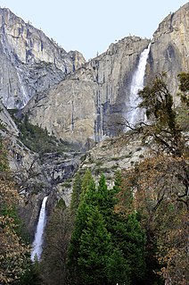
Yosemite Falls is the highest waterfall in Yosemite National Park, dropping a total of 2,425 feet (739 m) from the top of the upper fall to the base of the lower fall. Located in the Sierra Nevada of California, it is a major attraction in the park, especially in late spring when the water flow is at its peak.

Verkeerder Kill Falls is the highest waterfall in Sam's Point Preserve in the Shawangunk Mountains in the town of Shawangunk, Ulster County, New York. It is 187 feet (57 m) tall and is accessible via a three-mile-long (4.8 km) trail, part of the Long Path, which branches off from the main trail in Sam's Point Preserve. The waterfall is named after the stream. The waterfall may be viewed from the bottom or from the edge of a rocky outcrop; however, the only way to get to the bottom is to bushwhack. There are no fences along the rocky outcrops, which are higher than the waterfall is tall.

Hunter Mountain is in the towns of Hunter and Lexington, just south of the village of Hunter, in Greene County, New York, United States. At approximately 4,040 feet (1,231 m) in elevation, it is the highest peak in the county and the second-highest peak in the Catskill Mountains.

Taughannock Falls State Park is a 750-acre (3.0 km2) state park located in the town of Ulysses in Tompkins County, New York in the United States. The park is northwest of Ithaca near Trumansburg.

The Long Path is a 357-mile (575 km) long-distance hiking trail beginning in New York City, at the West 175th Street subway station near the George Washington Bridge and ending at Altamont, New York, in the Albany area. While not yet a continuous trail, relying on road walks in some areas, it nevertheless takes in many of the popular hiking attractions west of the Hudson River, such as the New Jersey Palisades, Harriman State Park, the Shawangunk Ridge and the Catskill Mountains. It offers hikers a diversity of environments to pass through, from suburbia and sea-level salt marshes along the Hudson to wilderness and boreal forest on Catskill summits 4,000 feet (1,220 m) in elevation.

Kaaterskill Falls is a two-stage waterfall on Spruce Creek in the eastern Catskill Mountains of New York, between the hamlets of Haines Falls and Palenville in Greene County. The two cascades total 260 feet in height, making Kaaterskill Falls one of the highest waterfalls in New York, and one of the Eastern United States' tallest waterfalls.
The High Peaks Wilderness Area, the largest Forest Preserve unit in the U.S. state of New York, is located in three counties and six towns in the Adirondack Park: Harrietstown in Franklin County, North Elba, Keene, North Hudson and Newcomb in Essex County and Long Lake in Hamilton County.
The Silver Lake Wilderness Area, an Adirondack Park unit of the Forest Preserve, is located in the towns of Lake Pleasant, Benson, Wells and Arietta in Hamilton County and is roughly bounded on the north by NY 8 and private lands near Piseco Lake, Oxbow Lake, Hamilton Lake, Sand Lake and Lake Pleasant; on the east by NY 30; on the south generally by the Hamilton County line; and on the west by NY 10, the West Branch of the Sacandaga River and the Piseco Outlet.
The West Canada Lake Wilderness Area is an Adirondack Park Forest Preserve management unit in the State of New York, USA.

Setrock Creek Falls is a waterfall in the Pisgah National Forest, in North Carolina.
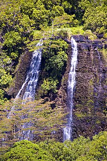
ʻŌpaekaʻa Falls is a waterfall located on the ʻŌpaekaʻa Stream in Wailua River State Park on the eastern side of the Hawaiian island of Kauai. It is a 151-foot (46 m) waterfall that flows over basalt from volcanic eruptions millions of years ago. Below the ridge down into the ravine through which the water falls can be seen the vertical dikes of basalt that cut through the horizontal Koloa lava flows. The name "ʻŌpaekaʻa" means rolling shrimp, "ʻopae" being Hawaiian for "shrimp," and "kaʻa" for "rolling". The name dates back to days when the native freshwater shrimp Atyoida bisulcata were plentiful in the stream and were seen rolling and tumbling down the falls and into the churning waters at the fall's base.

Hadley Mountain is a mountain located in the southern Adirondacks in the U.S. state of New York and is the second highest peak in Saratoga County after neighboring Tenant Mountain. The Hadley Mountain Fire Observation Station was listed on the National Register of Historic Places on September 23, 2001 for its role as a Fire lookout tower with the New York State Forest Preserve. Hadley Mountain is the highest of the three peaks that form the West Mountain ridge.

Balsam Mountain is one of the High Peaks of the Catskill Mountains in the U.S. state of New York. Its exact height has not been determined, so the highest contour line, 3,600 feet (1,100 m), is usually given as its elevation. It is located in western Ulster County, on the divide between the Hudson and Delaware watersheds. The summit and western slopes of the peak are within the Town of Hardenburgh and its eastern slopes are in Shandaken. The small community of Oliverea is near its base on that side. Most of the mountain is publicly owned, managed by the New York State Department of Environmental Conservation as part of the state Forest Preserve, part of the Big Indian-Beaverkill Range Wilderness Area in the Catskill Park. The summit is on a small corner of private land.

High Falls is a small but picturesque waterfall on the upper Oswegatchie River in the Five Ponds Wilderness. It is located in the town of Fine, in a remote part of Adirondack State Park in St. Lawrence County. The falls drops about 20 feet (6.1 m). Access is by canoe or by maintained hiking trails. The closest public road, near Wanakena, is almost six miles to the north. Trail access is by a short spur from the High Falls Loop Trail. The most direct canoe access is by way of the Oswegatchie River from the Oswegatchie River Inlet on Inlet Road. The waterfall has been designated a scenic special interest area in the New York State Land Master Plan.

Salt Creek Falls is a cascade and plunge waterfall on Salt Creek, a tributary of the Middle Fork Willamette River, that plunges into a gaping canyon in the Willamette National Forest near Willamette Pass in Lane County, Oregon. The waterfall is notable for its main drop of 286 feet (87 m), ranking third highest among plunge waterfalls in Oregon, after Multnomah Falls and Watson Falls.) The pool at the bottom of Salt Creek Falls waterfall is 66 feet (20 m) deep.

The Balsam Lake Mountain Fire Observation Station is located at the summit of the mountain of that name in the Town of Hardenburgh, New York, United States. It comprises a steel frame fire lookout tower, the observer's cabin and privy and the jeep road to the complex.
John E. Winkler (1941–2007) was an author of and photographer for books, articles and calendars that typically featured his unique off-trail location representations of the Adirondack and Shawangunk Mountains of New York State. He was the only "46er" to have bushwhacked all 46 of the Adirondack high peaks.
Groff Creek is a minor tributary of the Sacandaga River, and a hiking trail located in the Adirondack State Park in Hope, New York. The trail is an old logging road to camps along Devorse creek, containing three waterfalls and densely packed eastern hemlock trees and red spruce.

Jamaica State Park is a 772-acre state park in Jamaica, Vermont, on the shore of the West River.

