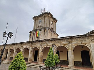
San Marcos is a department in northwestern Guatemala, on the Pacific Ocean and along the western Guatemala-Mexico border.
San Bartolomé Milpas Altas is a town and municipality in the Guatemalan department of Sacatepéquez.

Chiantla is a town and municipality in the Guatemalan department of Huehuetenango. The municipality is situated at 2,000 metres above sea level and covers an area of 521 km2. The annual festival is on January 28.

Jacaltenango is a town and municipality situated in the Western Highlands of Guatemala. It is located in a valley surrounded by the Sierra Madre Mountains. Jacaltenango serves as the municipal seat for the surrounding municipality of the same name. In 2002, its urban population was about 23,500 but at the 2018 census the town's population has decreased to 22,533.

San Pedro Soloma is a town and municipality of Huehuetenango, a department of Guatemala. It is located in the Sierra de los Cuchumatanes at 2,300 m above sea level. The municipality covers a total area of 264 km2 with elevations ranging from 1,900 m to 3,500 m. Its population of 49,030 is spread over the town of Soloma, 19 villages and 50 smaller rural communities (caserios).

San Juan Comalapa is a town, with a population of 32,312, and a municipality in the Chimaltenango department of Guatemala.

Santa Catarina Pinula is a town, with a population of 70,982 and a municipality in the Guatemala Department of Guatemala.
Concepción Chiquirichapa is a municipality in the Guatemalan department of Quetzaltenango in the Western Highlands of Guatemala, 14 kilometers west of the departmental capital of Quetzaltenango, and 214 kilometers west of the capital Guatemala City. The municipality has a population of 17,342, 98% of whom identify as indigenous Maya-Mam and speak a dialect of Southern Mam.

San Juan Ostuncalco, is a town, with a population of 20,763, and a municipality in the Quetzaltenango department of Guatemala. Beside Spanish, local people speak the Mam language.
Comitancillo is a town and municipality in the San Marcos department of Guatemala.The spoken language is Mam.The municipality was founded by the Spaniards between 1633 and 1648 year. There is an archaeological site called Chipel, with remains of the Mam culture.
Concepción Tutuapa is a town and municipality in the San Marcos department of Guatemala. It had a population of 49,363 according to the census of 2002 and of the 2018 census there is a total population of 68,148.

Ixchiguán is a municipality in the San Marcos department of Guatemala. The economy is based on temporary work force on the coffee plantations, respectively on a male migrating work force in Mexico.
Malacatán is a town and municipality in the San Marcos department of Guatemala, located to the west of San Marcos town. It is fairly close to the border with Mexico - the border-crossing point is in the nearby village of El Carmen.

Tejutla is a municipality in the western highlands of Guatemala, in the department of San Marcos. Tejutla was officially founded on 25 July 1672, although it was already an important town within the Mam kingdom in 1524, at the time of the Spanish conquest of Guatemala. It is situated high in the mountains, the so-called "cold zone", at about 2500 m altitude.
San Miguel Ixtahuacán is a municipality in the San Marcos department of Guatemala. It comprises 19 villages, and the population is about 39,000 people. The majority of people are ethnically Maya- Mam and speak the Mam and Spanish languages. Most inhabitants subsist by farming, growing crops of corn, beans, vegetables and fruits, irrigated from the Cuilco River and its tributaries.
Sibinal is a municipality in the San Marcos department of Guatemala. Its name comes from mam tziben (English: "Writing" and nal, meaning "Bernard writings" It was founded in February 1799. It is a mountainous municipality at an altitude about 2500 m near the Mexican-Guatemalan border. The village of Sibinal is one of the points for climbing towards the Volcano Tacaná.
Sipacapa is a municipality in the San Marcos department, situated in the Western highlands of Guatemala. Sipacapa's population of around 14,000 is spread among 14 village communities, scattered over mountainous terrain. Sipacapa is considered a linguistic community, as Sipakapense is a Maya language unique to the municipality.
Tajumulco is a municipality in the San Marcos department of Guatemala.
Concepción is a municipality in the Sololá department of Guatemala. The outstanding characteristic of the municipality is that 100% of its inhabitants are native people.
San Andrés Semetabaj is a municipality in the Sololá department of Guatemala. According to Jorge Luis Arriola's Geonimias de Guatemala, Semetabaj means "stone of glass-like appearance" and originates from the Spanish word "semet", which means : bottle or flask and, by extension, glass, and by the k'akch'iquel "abaj" which means "stone". Originally, it was called San Andrés Limetabaj.


