
Uttara Kannada is a district in the Indian state of Karnataka. It is a major coastal district of Karnataka, and is the third largest district in Karnataka. It is bordered by the state of Goa and Belagavi districts to the north, Dharwad District and Haveri District to the east, Shivamogga District, and Udupi District to the south, and the Laccadive Sea to the west.
Torke is a small village in Kumta taluk of Uttara Kannada district, Karnataka, India. This village is about a few square kilometres in extent. Torke traditionally is the amalgamation of Hoskatt, Naranapur, Toregazani, Torke, Devarabhavi, Hallergudi, Devana and Gonehalli. It has a Gram Panchayat.
Ankola is a Town Municipal Council and a taluka in Uttara Kannada district of the Indian state of Karnataka. The name of the place is derived from a forest shrub Ankola grown on the coastal hill side and worshiped by the Halakki Vokkaligas as a totem. The town is around 33 km (21 mi) from Karwar and 86 km (53 mi) from Sirsi.

Kumta is a town and taluk in the Uttara Kannada district of Karnataka, India. It is one of the important stations along the Konkan Railway line running between Mumbai and Mangalore.
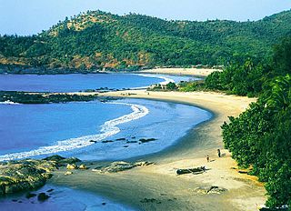
Gokarna is a small temple town located in the Uttara Kannada district of Karnataka state in southern India, It has a population of around 20,000. Shiva is the most worshipped deity in the town. Gokarna's main temple, Mahabaleshwara, is dedicated to Shiva. The temple houses what is believed by some to be the earliest Shiva lingam (Atmalinga).

Sirsi is a city and a taluk headquarter in Uttara Kannada district of Karnataka state in India. It was also known as Kalyana Pattana during the Sonda Dynasty. It is a tourist destination with evergreen forest and waterfalls and is also a commercial centre. The main businesses around the city are mostly subsistence and agriculture-based. Areca nut or betel nut, locally known as Adike, is the primary crop grown in the nearby villages, making it one of the major trading centres for areca nut. The region is also known for spices such as cardamom, pepper, betel leaves, and vanilla. The major food crop is paddy.
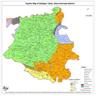
Siddapur Taluk is the destination of world famous Jog Falls. It is a part of Uttara Kannada district, Karnataka, India and is located in the midst of forest areas of Western Ghats and it is also a part of Malenadu. The taluk is full of greenery, hills and arecanut gardens developed in the valleys’. The taluk headquarters is Siddapur. Sirsi is the nearest city,
Karnataka's coastline called Karavali stretches 300 km between Mangalore in Dakshina Kannada district and Karwar in Uttara Kannada district. The coastline of Karnataka has been along the eastern shore of Arabian Sea. Karnataka has one major and ten minor ports in this coastal belt. Kali, Belekeri, Gangavali, Aghanashini Sharavathi, Sharabi, Kollur, Gangolli, Sitanadi, Gurpur and Netravati are the important rivers in this belt which empty into the Arabian sea. Sea erosion, migration of river mouths, siltation of ports and harbours are some of the problems common to this belt.
Holanagadde is a village in the Uttara Kannada district of the state of Karnataka, India. It is located on the west coast beach of the Arabian sea. The main communities that live in the village are Havyakas, Namdharis, Harikanths, Patgars with a few Christian and Mukhri families. The village has a primary school which is more than 160 years old. Rice, cashew nuts, betel nuts and coconuts are the main crops. Carpentry and agriculture are the major occupations in the area.
Bankikodla and Hanehalli are the twin neighbouring villages in a valley in Uttara Kannada district in the Indian state of Karnataka.
Majali is a hamlet in the Uttar Kannada district of Karnataka, India. It is situated in a coastal region called Kanara at the Goa-Karnataka border. The language spoken there are Konkani and Kannada.

Sadashivgad is a village located in Karwar, Uttara Kannada district, in the state of Karnataka in India. Significant and picturesque, it is now a popular tourist destination located by the Kali river bridge, which has been built at the confluence of the river and the Arabian Sea.

Yana is a tourist destination located in forest of Katgal Range, which is also a part of Malenadu region of Uttara Kannada district of Karnataka state in India. Yana is one of the wettest villages in the world. It is the cleanest village in Karnataka and the second cleanest village in India. The two unique rock outcrops after the village are tourist attractions and easily approachable by two routes one from Kumta-Sirsi Highway by a small trek through 0.5 kilometres (0.31 mi) the thick forests from the nearest road head and another from Sirsi-Ankola Road.
Sanikatta is a twin village in Kumta taluk of Uttara Kannada district, Karnataka, India. This place is about a few square kilometres in extent. It is in the neighborhood of Gokarna, Devarbhavi, Torke and Tadadi port. The place Sanikatta is the oldest salt-manufacturing village in the Karnataka State. Beginning from 1720, Sanikatta has continued manufacturing salt for nearly 300 years.
Kadekodi is a small village situated on the National Highway 17 (NH17) on the way from Honnavar to Kumta. Kadekodi is part of Kumta Taluk, Uttara Kannada district, Karnataka State
Charekone is a small village in Siddapura Taluk Uttara Kannada District, Karnataka State; Which is about 32 kilometres (20 mi) from Sirsi and 28 kilometres (17 mi) from Siddapur.

Karwar railway station is one of the main railway station in Uttara Kannada, Karnataka. Its code is KAWR. It is the headquarters of the Karwar Division of Konkan Railway(Pernem-Thokur). It serves Karwar city. The station consists of two platforms. Karwar has three nearby railway stations: Karwar, Asnoti and Harwada. A 1.69 km (1.05 mi) railway bridge on Kali River falls before Karwar Railway Station while travelling from the side of Goa. The town of Karwar is situated beside Kali River.
Panchaganga Express is an Express train belonging to South Western Railway zone that runs between Bangalore City and Karwar in India via Shortest possible Padil Bypass route. It is currently being operated with 16595/16596 train numbers on a daily basis.

Vibhuthi Falls is located in Achave Gram panchayat,Ankola taluk of Uttara Kannada district in Karnataka, India. The word "Vibhuthi" means limestone. The water in this falls comes past limestone rocks near Yana and so the falls is called as "Vibhuthi Falls". Nearest towns near Vibhuthi falls are Sirsi, Kumta, Ankola, Gokarna.
Chendia-Todur is a twin village in the Karwar Taluk of Uttar Kannada District of Karnataka. It lies 13 km south of the city of Karwar, 257 km north of the chief port city Mangalore and 489 km from the state capital Bangalore.
