Satara is a city located in the Satara District of Maharashtra state of India, near the confluence of the river Krishna and its tributary, the Venna. The city was established in the 16th century and was the seat of the Chhatrapati of Maratha Empire, Shahu I. It is the headquarters of Satara Tehsil, as well as the Satara District. The city gets its name from the seven forts (Sat-Tara) which are around the city. The city is known as a Soldier's city as well as Pensioner's city.
Shirur is an administrative subdivision of the Pune district in the Indian state of Maharashtra. It is located on the east boundary of the Pune district, on the banks of the Ghod River. The town is also called Ghodnadi to distinguish it from other locations that have the same name. Ghodnadi in Marathi Language means Ghod River.
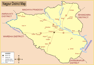
Mouda, is a town and a Tehsil in the Ramtek subdivision of the Nagpur district in the Nagpur Revenue Division. It is situated in the Berar region in the state of Maharashtra, India. The total area covered under this Tehsil is around 61,293.17 hectares. The population of this tehsil is around 37,554 according to the 1991 census. The nearest city to Mouda is Nagpur, which is 38 km away. The total number of villages in this tehsil is 41. Mouda is famous for its fertile agricultural land. Therefore, the main occupation is farming. Average rainfall here is estimated to be around 1223.3mm. It is located on the banks of Kanhan River and near National Highway 6.
Koregaon is a census town and headquarters for the surrounding Koregaon Taluka in the Satara subdivision of Satara district in the Indian state of Maharashtra. It is situated on the Satara-Pandarpur road about 18 km east of Satara city, about 120 km from Pune and 267 km from Mumbai. The Koregaon railway station, situated on the Pune - Miraj line, is 2 kilometers outside the town. At a stone's throw from the railway station is Koregaon Bus Station.
Atpadi is an administrative town of the Atpadi Taluka of Sangli District in the Indian state of Maharashtra. Atpadi is located north-east of Sangli District and shares borders with the adjacent Solapur and Satara Districts. The town has a taluka administrative office, a courthouse, a police station, a government-run primary hospital, various schools and colleges and a theater. Atpadi's economy is based on the cultivation and sale of agricultural products, with pomegranates and cotton constituting the core of the industry. The town is also home to the Manganga Sahakari Sugar factory, a Pomegranate auction center and various small scale industries in fields such as manufacturing, processing, servicing and repairs.
Bhoite is a surname found amongst the Maratha caste, mainly in the state of Maharashtra in India but it also appears in Indian states bordering Maharashtra.
Hingangaon is a small town and Gram panchayat in Phaltan Tehsil, District Satara of the Indian state of Maharashtra. It is situated in a mountainous region, 6–8 km from the Pune-Pandharpur Highway and Phaltan-Satara Roads mounted on Deccan Plateau.
Aradgaon is a village in Phaltan Tehsil, Satara district, Maharashtra.
Sakharwadi is a town and Gram panchayat of Phaltan tehsil, Satara district, Maharashtra, India. It is situated at about 15 kilometres (9.3 mi) north-east of Phaltan city and approximately 60 kilometres (37 mi) north-west of Satara city.sakharwadi In Shree Dutt India Sugar mill. Take over 2019
Khandala is a town and taluka in the Satara district in the Indian state of Maharashtra.
Kudal (कुडाळ) is a village in the Satara district, Maharashtra, India. It is surrounded by a river called Niranjana or Kudali. There is a big temple of 'Pimpleshwar & Wakadeshwar' at the river coast. Agriculture is the main land use in the village, with more than 75% of the total area being used for agricultural activities. The village has a close view to the historic Vairatgad Fort. It is central for 15 villages situated nearby Kudal Village.
Pune railway division is one of the five railway divisions of Central Railway (India) Zone of Indian Railways located at Pune of Maharashtra state in western India. The other railway divisions are Mumbai CSMT, Nagpur, Solapur and Bhusawal. There are 71 railway stations in Pune railway division. station will now be a part of pune Railway division. 24 stations of daund-Ankai section will be merged with pune Railway division. Currently Daund-Ankai section is under solapur railway division. Merging with pune division will incarese the chances of starting demu services between Ahmednagar and pune railway station.
Wagholi is a town in Pune district of Maharashtra, India. It is situated on the outskirts of Pune city so many people working or studying in Pune live here due to lower rents and cost-of-living. It plays an important role in the economic, social, cultural, and educational lives of people in the Pune, Koregaon, and Satara Districts.
Koregaon Bhima is a panchayat village and census town in the state of Maharashtra, India, on the left (north) bank of the Bhima River. Administratively, Koregaon Bhima is under Shirur Taluka of Pune District in Maharashtra. There is only the single town of Koregaon Bhima in the Koregaon Bhima gram panchayat. The town of Koregaon Bhima is 10 km along the SH 60 motorway southwest of the village of Shikrapur, and 28 km by road northeast of the city of Pune. It is the site of the Battle of Koregaon fought on 1 January 1818.
Shikrapur is a panchayat village in the state of Maharashtra, India. It is the largest village in the Shirur Taluka of Pune District in Maharashtra.
Murum is a village and Gram Panchayat in Baramati Taluka in Pune District of Maharashtra State, India. It belongs to Desh or Paschim Maharashtra region. It is located 78 km south of District headquarters Pune. 34 km from Baramati.
Banawadi is a census village of Satara district in the Indian state of Maharashtra. It is situated near to the Satara Phaltan state highway, about 21 km north of Satara, about 108 km from Pune and 220 km from Mumbai.

Vaduj is a major town in Satara district of Maharashtra, India. It is the headquarters of Khatav Taluka. It is located on the banks of the Yerala river, and is around 58 kilometres (36 mi) away from the district capital Satara, and 165 kilometres (103 mi) away from Pune. It is the biggest town in Khatav Taluka, with a population of around 32,636 people. According to the 2011 population census, it has a literacy rate of 86%, which is above the national average. Recently, its status was changed to Nagar Panchayat.
Garavadi (Ramnagar) is a census village in the Satara district, which is located in the India state of Maharashtra. There are a total of approximately 240 families residing within its borders. The village is located in the Khatav Tehsil of Satara district in Maharashtra, India. It is 32 km away from the sub-district headquarters of Vaduj, and 54 km away from the district headquarters of Satara. Research from 2009 shows that Garavadi village is also classified as a gram panchayat. According to the India Census in 2011, the village was recorded to have a population of 997, 478 of which were males, and the other 519 females.
Lonand is a city and municipal council in Satara district, Maharashtra. It is 227km from Mumbai, 81km from Pune, 47km from Wai & Satara,179km from Sangli and 30km from Phaltan.


