
Rhondda Cynon Taf is a county borough in the south-east of Wales. It consists of five valleys: the Rhondda Fawr, Rhondda Fach, Cynon, Taff and Ely valleys, plus several towns and villages away from the valleys.

Merthyr Tydfil is the main town in Merthyr Tydfil County Borough, Wales, administered by Merthyr Tydfil County Borough Council. It is about 23 miles (37 km) north of Cardiff. Often called just Merthyr, it is said to be named after Tydfil, daughter of King Brychan of Brycheiniog, who according to legend was slain at Merthyr by pagans about 480 CE. Merthyr generally means "martyr" in modern Welsh, but here closer to the Latin martyrium: a place of worship built over a martyr's relics. Similar place names in south Wales are Merthyr Cynog, Merthyr Dyfan and Merthyr Mawr.

Ynysybwl is a village in Cwm Clydach in Wales. It is situated in the county borough of Rhondda Cynon Taf, roughly 15 miles (24 km) north-north-west of Cardiff, 4 miles (6 km) north of Pontypridd and 16 miles (26 km) south of Merthyr Tydfil, and forms part of the community of Ynysybwl and Coed-y-Cwm.

The Taff Trail is a walking and cycle path that runs for 55 miles (89 km) between Cardiff Bay and Brecon in Wales. It is so named because it follows the course of the River Taff. Along much of its length, it follows the National Cycle Network Route 8 that continues to Holyhead, and is substantially off-road.

The River Taff is a river in Wales. It rises in the Brecon Beacons as two rivers, the Taf Fechan and the Taf Fawr before becoming one just north of Merthyr Tydfil. At Cardiff, it empties into the Bristol Channel.
The Rhymney Railway (RR) was a railway company in South Wales, founded to transport minerals and materials to and from collieries and ironworks in the Rhymney Valley of South Wales, and to docks in Cardiff. It opened a main line in 1858, and a limited passenger service was operated in addition.

The South Wales Valleys are a group of industrialised peri-urban valleys in South Wales. Most of the valleys run north–south, roughly parallel to each other. Commonly referred to as "The Valleys", they stretch from Carmarthenshire in the west to Monmouthshire in the east; to the edge of the pastoral country of the Vale of Glamorgan and the coastal plain near the cities of Swansea, Cardiff, and Newport.
Bedlinog is a small village located in The Taff Bargoed valley, 10 km (6 mi) north of Pontypridd, 10 km (6 mi) north west of Caerphilly and 10 km (6 mi) south east of Merthyr Tydfil in south-east Wales. It is currently in the south of Merthyr Tydfil County Borough, but until 1974 was part of Gelligaer Urban District Council in the county of Glamorgan.

Abercanaid is a small village in the county borough of Merthyr Tydfil, Glamorgan, Wales, United Kingdom with a population of about 5,060. It is situated 2.5 miles (4.0 km) south of Merthyr town centre and is west of Pentrebach, across the River Taff and north of Troedyrhiw. The Taff Trail runs through the village, adjacent to the path of the disused Glamorganshire Canal, which was an important in transporting iron and coal during the industrial boom in which the South Wales Valleys prospered.

Cwmdare is a village very close to Aberdare, in Rhondda Cynon Taf, Wales. The village's history is intertwined with coal-mining, and since the decline of the industry in the 1980s, it has become primarily a commuter base for the larger surrounding towns of Aberdare and Merthyr Tydfil and Pontypridd, as well as the cities of Cardiff and Swansea.

Treharris Athletic Western F.C. is a football club from Treharris in south Wales who play in the Ardal SE League. Their home ground is based in Parc Taf Bargoed in the neighbouring village, Trelewis.

Merthyr Vale is a linear village and community in the Welsh county borough of Merthyr Tydfil. Lying on the A4054 road it is on the east bank of the River Taff.

Treharris is a small town and community in the Taff Bargoed Valley in the south of Merthyr Tydfil County Borough, South Wales. It is located about 0.6 miles (1.0 km) west of Trelewis, from which it is separated by the Taff Bargoed river, and 0.9 miles (1.4 km) from Nelson in Caerphilly county borough and has a population of 6,356 from the 2011 Census. As a community, Treharris includes the villages of Quakers Yard and Edwardsville. Due to steepness and narrowness of both the Taff and Taff Bargoed valleys at Treharris several notable bridges and viaducts have been built in the area.
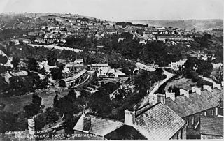
Quakers Yard or Quaker's Yard is a village in the Merthyr Tydfil County Borough, situated where the Taff Bargoed Valley joins the Taff Valley. The settlement is part of the community of Treharris.
Nelson is a village and community in the County Borough of Caerphilly, Wales. It sits five miles north of Caerphilly and ten miles north of Cardiff, at the lower end of the Taff Bargoed Valley, and lies adjacent to Treharris, Trelewis and Quakers Yard.

Trelewis is a small village in the Taff Bargoed Valley of south-east Wales, currently located in the southern part of Merthyr Tydfil County Borough. It is a former mining village and together with nearby Bedlinog was until 1974 part of the Gelligaer Urban District Council area of the county of Glamorgan. The villages name means 'Lewis Town' and was named after the Lewis family who owned a farm on the area where the village is now built.

Mynydd Cilfach-yr-encil attains a height of 445m at OS grid reference SO 079033 making it the high point of the broad ridge of high ground between Taff Vale and Cwm Bargod in the Valleys region of South Wales. It lies within the County Borough of Merthyr Tydfil.

Deep Navigation Colliery was a coal mine in South Wales, that operated from 1872 until 1991.

Merthyr Tydfil County Borough is a county borough in the south-east of Wales. In 2022, it had an estimated population of 58,883, making it the smallest local authority in Wales by population. It is located in the historic county of Glamorgan and takes its name from the town with the same name. The county borough consists of the northern part of the Taff Valley and the smaller neighbouring Taff Bargoed Valley. It borders the counties of Rhondda Cynon Taf to the west, Caerphilly County Borough to the east, and Powys to the north.

Cwm Bargoed railway station was near the village of Fochriw, in the Taff Bargoed valley of Caerphilly County Borough, Wales, from 1876 to 1964 on the Rhymney Railway. The station was 4 km (2.5 mi) east of Merthyr Tydfil, but was in a parallel valley.
