Taganrog Fortress

Last updated
Taganrog Fortress'
Saint Trinity fortress
Таганрогская крепость
Троецкая крепость на Таганьем Рогу
Taganrog, Russia
Taganrog Fortress.jpg
Type star fort
Site information
Controlled by Peter the Great, Aleksei Shein, Cornelis Cruys
Conditionruined
Site history
Built1696-1709, 1769-1773
Built by Ernst Friedrich von Borgsdorf, Mikhail Dedenev
In use1709-1712, 1769-1810
Materials earthworks

Taganrog Fortress (also The Saint Trinity fortress on Tagan-Rog Cape) was a star fort-style fortress built during the reign of Peter the Great and re-constructed by the order of Catherine the Great.

Contents

Foundation of Taganrog

Plan of the Taganrog fortification and artificial haven Taganrog Fortress1698.jpg
Plan of the Taganrog fortification and artificial haven

Peter the Great tried to conquer the Turkish fortress of Azov to get an entrance to the Sea of Azov and the Black Sea. His first Azov campaigns in 1695 failed, but his second attempt the next year led to victory.

To ensure Russian positions in the South, and to shelter the Russian Navy, Peter the Great needed a new haven for the Azov Flotilla, and a fortress to protect it. Azov could not serve as naval base because of shallow waters of the river Don. That is why, a few days after Turkish capitulation, on July 27, 1696 the Russian tsar set out for an expedition to explore the coastline of Azov Sea. The expedition stopped at the cape Tagan-Rog on July 27, where Peter the Great spent the night of July 27–28, 1696. The cape was selected as the perfect place for the harbour, since the sea around the cape was deep enough for sea boats; there was enough room for a haven with solid stone soil; and the expedition found a small water spring.

The first Russian Navy base, Taganrog (Taygan for Turkish in Ottoman sources) was officially founded by Peter the Great on September 12, 1698. Vice-Admiral Cornelis Cruys, who is regarded as the architect of the Russian Navy, became the first Head of Taganrog city in 1698-1702 and in 1711, and produced the first maps of Azov Sea and Don River.

Construction of the fortress

Plan of Taganrog's haven, 1704. Taganrogskaia gavan'1.jpg
Plan of Taganrog's haven, 1704.

The project for planning and building works in the city was established in 1698 by Austrian engineer Baron Ernst Friedrich von Borgsdorf, basing on the instructions provided by Peter the Great. Taganrog is one of the first Russian cities, which was built according to a detailed pre-established plan. It was also the first artificial haven, and the first fortress made of earth as primary material. The construction was generally completed by 1709.

The Saint Trinity fortress was situated on the horn-shaped territory of the cape, earth mounds around 8 metres high, a 5-metre-deep moat that stretched for about 2 miles. Within fortress ramparts were other defensive constructions - three bastions, two demi-bastions, three ravelins armed with cannons and howitzers. Alongside the rampart were casemates, powder magazines, barracks. To prevent an eventual attack from the land there was an additional dry ditch 40 metres wide and 5 metres deep alongside the rampart.

Inside the fortress territory was laid out in a radial pattern of star fort united by the central plaza. It had monarch's house, various buildings, Saint Trinity cathedral, warehouses, marketplace, ovens and draw wells. By the middle of 1711 there were 206 buildings made of stone and 162 wood structures inside the fortress for garrison and inhabitants in case of a siege. The main part of the population lived outside the fortress in the so-called "slobodas". In 1711 the fortress was defended by 293 cannons and 40 howitzers not counting artillery in the haven and on Cherepakha Islet.

Taganrog haven's water area was about 774 thousand sq.metres, of rectangular form and was surrounded breakwaters. From the seaside were erected towers, the berth was near the coast. Taganrog seaport is considered as the first port in the world to be created in the open sea and not in a natural bay. Some 30 thousand oak piles were used in the construction of the haven with 199 boxes loaded with stones in between them.

Another part of this project was an artificial islet Cherepakha, which was made in the Azov Sea in about 2 kilometers from the fortress. The islet was 59 by 38 metres. There was a citadel, which had an area of 1200 square metres with 127 cannons. In the middle stood a wooden izba for garrison, which was later replaced by a stone building.

The islet was built by the personal order of Peter the Great in 1701-1706 of rock fill held by oak piles. In the present days, when the tide is low and blows East wind the islet emerges from the water. During the latest examination of islet in 1981, the remains of old oak piles were still present. [1]

After a defeat suffered by Russian troops from Ottoman Empire during Pruth River Campaign, the Russian tzar had to sign Treaty of the Pruth, returning Azov to Turkey and destroying Taganrog. On September 19, 1711 by the order of Peter the Great, Taganrog was demolished and in February 1712 Russian troops left the town.

Short revival

For fifty years, the seaport, fortress and town lay in ruins. On April 2, 1769, Russian troops entered Taganrog, and it was definitively ceded by Turkey in the Treaty of Kuchuk Kainarji (1774). The city was re-founded by Catherine the Great, who issued a special decree addressed to the Vice-Admiral Aleksey Senyavin. The reconstruction of the fortress was planned by Russian engineer Mikhail Alexeevich Dedenev.


However after the Crimea was annexed by Russian Emprire in 1783, Taganrog Fortress lost its military importance and February 10, 1784, Empress Catherine I signed a decree abolishing the fortifications and transferring the lands in favor of the city. The ships of the Azov Flotilla were transferred into the new city and navy base of Sevastopol, and later in 1803 the bells and plates of the Saint Nicholas Church, including The bell of Chersonesos, were also given in favor of a naval cathedral in Sevastopol.

Taganrog continued its development as a civic trade city. The fortress buildings were used for various purposes and were gradually demolished.

See also

Related Research Articles

<span class="mw-page-title-main">Sea of Azov</span> Sea on the south of Eastern Europe linked to the Black Sea

The Sea of Azov is an inland shelf sea in Eastern Europe connected to the Black Sea by the narrow Strait of Kerch, and is sometimes regarded as a northern extension of the Black Sea. The sea is bounded by Russia on the east, and by Ukraine on the northwest and southwest, currently under Russian occupation. It is an important access route for Central Asia, from the Caspian Sea via the Volga–Don Canal.

<span class="mw-page-title-main">Azov</span> Town in Rostov Oblast, Russia

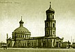
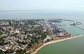
Azov, previously known as Azak , is a town in Rostov Oblast, Russia, situated on the Don River just 16 kilometers (9.9 mi) from the Sea of Azov, which derives its name from the town. Population: 81,924 (2021 Census); 82,937 (2010 Census); 82,090 (2002 Census); 80,297 (1989 Census).

<span class="mw-page-title-main">Treaty of Karlowitz</span> 1699 peace treaty in the context of Great Turkish War

The Treaty of Karlowitz, concluding the Great Turkish War of 1683–1697, in which the Ottoman Empire was defeated by the Holy League at the Battle of Zenta, was signed in Karlowitz, in the Military Frontier of the Archduchy of Austria, on 26 January 1699. Also known as "The Austrian treaty that saved Europe", it marks the end of Ottoman control in much of Central Europe, with their first major territorial losses in Europe, beginning the reversal of four centuries of expansion (1299–1683). The treaty established the Habsburg monarchy as the dominant power of the region.

<span class="mw-page-title-main">Fyodor Apraksin</span> 17th/18th-century Russian admiral

Count Fyodor Matveyevich Apraksin was one of the first Russian admirals, governed Estonia and Karelia from 1712 to 1723, was made general admiral (1708), presided over the Russian Admiralty from 1718 and commanded the Baltic Fleet from 1723.

<span class="mw-page-title-main">Azov campaigns (1695–1696)</span> Russian military campaigns during the Russo-Turkish War of 1686–1700

The Azov campaigns of 1695–1696, were two Russian military campaigns during the Russo-Turkish War of 1686–1700, led by Peter the Great and aimed at capturing the Turkish fortress of Azov with the aim of controlling the southern mouth of the Don River gaining access to the Sea of Azov and entrance to the Black Sea. Despite stubborn resistance and heavy casualties, the Russians under General Sheremetev after a failed siege in 1695 managed to capture the fort, accompanied by a naval force, in July 1696, marking the first major Russian victory against the Turks.

<span class="mw-page-title-main">Pruth River Campaign</span> 1710–1711 Russo-Ottoman conflict of the Great Northern War

The Russo-Ottoman War of 1710–1711, also known as the Pruth River Campaign, was a brief military conflict between the Tsardom of Russia and the Ottoman Empire. The main battle took place during 18-22 July 1711 in the basin of the Pruth river near Stănilești after Tsar Peter I entered the Ottoman vassal Principality of Moldavia, following the Ottoman Empire’s declaration of war on Russia. The ill-prepared 38,000 Russians with 5,000 Moldavians, found themselves surrounded by the Ottoman Army under Grand Vizier Baltacı Mehmet Pasha. After three days of fighting and heavy casualties the Tsar and his army were allowed to withdraw after agreeing to abandon the fortress of Azov and its surrounding territory. The Ottoman victory led to the Treaty of the Pruth which was confirmed by the Treaty of Adrianople.

Ivan Andreevich Tolstoy (1644–1713) was a Russian officer in the army of Tsar Peter I.

<span class="mw-page-title-main">Cornelius Cruys</span> Dutch naval commander

Cornelius Cruys was a Norwegian–Dutch admiral of the Imperial Russian Navy, and the first commander of the Russian Baltic Fleet.

<span class="mw-page-title-main">History of Taganrog</span>

The southern Russian city of Taganrog began as one of Russia's first planned cities under Peter the Great. To protect the newly conquered Sea of Azov region, the Russians opened a naval base there in 1698 and a city and seaport were built. However, after the Turkish victory in the war of 1710–1711, Taganrog city and port were demolished prior to handover to the Turks.

<span class="mw-page-title-main">Treaty of the Pruth</span> 1711 treaty between Russia and the Ottomans

The Treaty of the Pruth was signed on the banks of the river Prut between the Ottoman Empire and the Tsardom of Russia on 23 July 1711 ending the Russo-Turkish War of 1710–1711. The treaty was a political victory for the Ottoman Empire.

The Treaty of Constantinople or Istanbul was signed on 13 July 1700 between the Tsardom of Russia and the Ottoman Empire. It ended the Russo-Turkish War of 1686-1700. Russian tsar Peter the Great secured possession of the Azov region and freed his forces to participate in the Great Northern War. The treaty was superseded by the Treaty of the Pruth in 1711, after the Ottoman Empire became involved in this war.

<span class="mw-page-title-main">Alexei Senyavin</span>

Alexei Naumovich Senyavin was an admiral of the Imperial Russian Navy, son of Naum Senyavin.

<span class="mw-page-title-main">Baltacı Mehmet Pasha</span> Grand Vizier of the Ottoman Empire (1704–1706, 1710–1711)

Baltacı Mehmet Pasha was an Ottoman statesman who served as grand vizier of the Ottoman Empire, first from 1704 to 1706 and again in 1710 to 1711, and as Kapudan Pasha in 1704.

Devlet II Giray (1648–1718) was Khan of the Crimean Khanate from 1699 to 1702 and from 1709 to 1713. His eldest son was Selim I Giray.

<span class="mw-page-title-main">Azov Governorate</span> 1775–1783 unit of Russia

Azov Governorate was an administrative-territorial unit (guberniya) of the Russian Empire, which existed from 1775 to 1783. Its capital was in Belyov Fortress and later in Yekaterinoslav.

Cherepakha or Cherepashka was a small artificial islet, which was man-made on a sand bank in the Gulf of Taganrog on Azov Sea in about 2 kilometers from the Taganrog Fortress. Its sole purpose was to support the fortification with cannons thus creating additional defense for the Azov Flotilla.

<span class="mw-page-title-main">Old Turkish bay</span>

The Old Turkish bay is an ice-free bay of elongated arc-shaped form on the northern shore of Taganrog Bay in Azov Sea. It is located within the territories of Taganrog city and Petrushino town. The bay extends to the mainland at 1.25 km, the width of bay's entrance is 5.8 km. On its northern coast there is a city beach, which occupies 2.4 km of coastline.

<span class="mw-page-title-main">Azov Fortress</span> Fortress and museum in Azov, Rostov oblast Russia

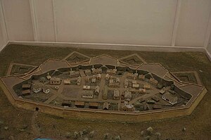
The Azov Fortress is a fortified complex in Azov, Rostov Oblast, Russia, overlooking the Don River and the Port of Azov to the north. It includes a rampart, watchtowers and gates. The Azov Fortress was founded by Turks on behalf of the Ottoman Empire in 1475. It guarded the northern approaches to the Empire and access to the Azov Sea. After a series of conflicts, a peace treaty was signed in Constantinople on July 13, 1700 between the Tsardom of Russia and the Ottoman Empire. The sultan recognized Russia's possession of the Azov area.

Lutic Fortress was a fortification structure located on the left bank of the northern channel of the Don delta, the River Mertvy Donets, in Rostov Oblast, close to Nedvigovka khutor. In the XVII-XVIII centuries the fortress was of strategic importance and defended the access to the Sea of Azov. After the Crimea Peninsula was incorporated into the Russian Empire, it fell into decay.

<span class="mw-page-title-main">Tagany Rog</span> Cape near Taganrog Bay of Azov Sea

Tagany Rog is a cape situated at the northern part of Taganrog Bay of Azov Sea. It is also the place of the old part of Taganrog city, which itself was named after the cape.

References

47°12′18″N38°57′00″E / 47.2050°N 38.9500°E / 47.2050; 38.9500