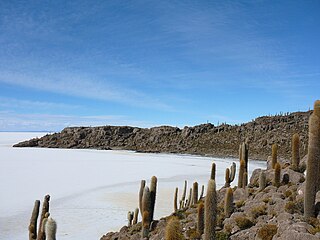
Isla Incahuasi, Inkawasi or Inka Wasi is a hilly and rocky outcrop of land and former island in Bolivia situated in the middle of Salar de Uyuni, the world's largest salt flat, at an elevation of 3,656 meters. It is located in the Potosí Department, Daniel Campos Province, Tahua Municipality, Yonza Canton. Isla Incahuasi is the Spanish name where isla means island, Inca stands for Inca, and huasi is derived from the Quechua word wasi meaning house.

Totora, Tutura or T'utura is a town in the Carrasco Province of the Cochabamba Department in Bolivia. It is the capital and most-populous place of the Totora Municipality. As of the 2012 census, the population is 1,925. The first settlers were Inca Indians. Totora was officially settled in 1876, and declared a town by the Government of Bolivia in 1894.

Achacachi Municipality is one of six municipalities of the Omasuyos Province in the La Paz Department in Bolivia. Its seat is Achacachi.

Jesús de Machaca is a location in the La Paz Department, Bolivia. It is the seat of the Jesús de Machaca Municipality, the sixth municipal section of the Ingavi Province, and of the Jesús de Machaca Canton. In 2001 it had a population of 396.
Sipe Sipe is a location in the Cochabamba Department in central Bolivia. It is the seat of the Sipe Sipe Municipality, the second municipal section of the Quillacollo Province.
Vinto is a town in the Cochabamba Department in central Bolivia. It is the seat of the Vinto Municipality, the fourth municipal section of the Quillacollo Province.

San Agustín Canton is one of the cantons of the Enrique Baldivieso Province in the Potosí Department in south-west Bolivia. During the census of 2001 it had 567 inhabitants. Its seat is San Agustín which is also the capital of the Enrique Baldivieso Province with a population of 533 in 2001. It lies at the Turuncha River
Llica Municipality is the first municipal section of the Daniel Campos Province in the Potosí Department in Bolivia. Its seat is Llica.
San Pedro de Quemes is one of the cantons of the San Pedro de Quemes Municipality, the second municipal section of the Nor Lípez Province in the Potosí Department of Bolivia. During the census of 2001 it had 574 inhabitants. Its seat is San Pedro de Quemes with a population of 490 in 2001.

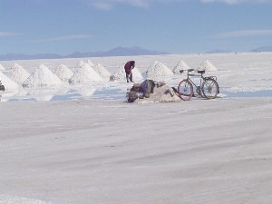
Coqueza is one of the cantons of the Tahua Municipality, the second municipal section of the Daniel Campos Province in the Potosí Department of Bolivia. During the census of 2001 it had 102 inhabitants. Its seat is Coqueza. The village is situated at the Salar de Uyuni and south of the Tunupa volcano.
Yonza is one of the cantons of the Tahua Municipality, the second municipal section of the Daniel Campos Province in the Potosí Department of Bolivia. During the census of 2001 it had 363 inhabitants. Its seat is Yonza. The canton is situated on a peninsula that juts into Salar de Uyuni on its southern end.
Caquena is one of the cantons of the Tahua Municipality, the second municipal section of the Daniel Campos Province in the Potosí Department of Bolivia. During the census of 2001 it had 325 inhabitants. Its seat is Caquena, situated at the Salar de Uyuni and west of Tunupa volcano.

Isla del Pescado, Isla de los Pescadores or Cujiri is a hilly and rocky outcrop of land in the middle of Salar de Uyuni – a salt flat situated in the Daniel Campos Province, Tahua Municipality, Caquena Canton, Bolivia.
Chipaya is a village in Bolivia located in the Sabaya Province of the Oruro Department. It is the seat of the Chipaya Municipality. In 2001 it had a population of 363. The village is situated in a remote area northeast of Lake Coipasa where the people have maintained special elements of their culture.

Tawa Qucha is a 3,582-metre-high (11,752 ft) mountain in the Bolivian Andes. It is located in the Chuquisaca Department, Azurduy Province, Tarvita Municipality. It lies at the Tawa Quchayuq Mayu whose waters flow to the Pillku Mayu :


