
Maryland is a state in the Mid-Atlantic region of the United States. It shares borders with Virginia, West Virginia, and the District of Columbia to its south and west; Pennsylvania to its north; and Delaware and the Atlantic Ocean to its east. Baltimore is the largest city in the state, and the capital is Annapolis. Among its occasional nicknames are Old Line State, the Free State, and the Chesapeake Bay State. It is named after the English Queen Henrietta Maria, then known in England as Mary.

Calvert County is located in the U.S. state of Maryland. As of the 2010 census, the population was 88,737. Its county seat is Prince Frederick. The county's name is derived from the family name of the Barons of Baltimore, the proprietors of the English Colony of Maryland.

Anne Arundel County, also notated as AA or A.A. County, is located in the U.S. state of Maryland. As of the 2020 United States census, its population was 588,261, an increase of just under 10% since 2010. Its county seat is Annapolis, which is also the capital of the state. The county is named for Lady Anne Arundell, a member of the ancient family of Arundells in Cornwall, England, and the wife of Cecilius Calvert, 2nd Baron Baltimore (1605–1675), founder and first lord proprietor of the colony Province of Maryland.

Charles County is a county in Southern Maryland. As of the 2020 census, the population was 166,617. The county seat is La Plata. The county was named for Charles Calvert (1637–1715), third Baron Baltimore.
St. Mary's County, established in 1637, is a county located in the U.S. state of Maryland. As of the 2010 census, the population was 113,777. Its county seat is Leonardtown. The name is in honor of Mary, the mother of Jesus.
Landover Hills is a town in Prince George's County, Maryland, United States. The population was 1,687 at the 2010 census. The town has a neighborhood named Defense Heights.

Leonardtown is a town in and the county seat of St. Mary's County, Maryland, United States. The population was 2,930 at the 2010 census. Leonardtown is perhaps most famous for the national oyster-shucking championship that is held annually at the St. Mary's County fairgrounds.

Lexington Park is a census-designated place (CDP) in St. Mary's County, Maryland, United States, and the principal community of the Lexington Park, Maryland Micropolitan Statistical Area. The population was 11,626 at the 2010 census.

Mechanicsville is an unincorporated community and census-designated place in St. Mary's County, Maryland, United States. It is adjacent to the community of Charlotte Hall, which is known for its agriculture, Amish population, large farmers' market/flea market, and the Maryland Veterans Home. Mechanicsville has many small businesses and restaurants along Maryland Route 5 and Maryland Route 235. This community is served by the St. Mary's County Public Schools, including Chopticon High School. As of the 2010 Census, Mechanicsville had a population of 1,508 people.
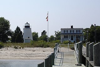
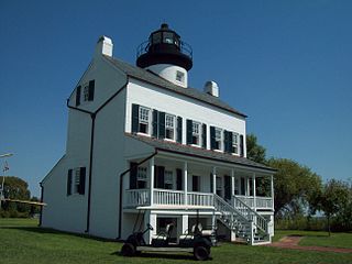
The Piney Point Lighthouse was built in 1836 located at Piney Point on the Potomac River in Maryland just up the river from the mouth of the Chesapeake Bay. The Coast Guard decommissioned it in 1964 and it has since become a museum. It is known as the Lighthouse of Presidents because several early US Presidents visited or stayed on the grounds.

Aquasco is an unincorporated area and census-designated place in southeastern Prince George's County, Maryland, United States, surrounding the town of Eagle Harbor and bordering Charles County. As of the 2020 census, the CDP had a population of 913. Aquasco was home to the Aquasco Speedway.
Brownsville is an unincorporated community and census-designated place in Washington County, Maryland, United States, near Gapland in an area known as Pleasant Valley. Its population was 89 as of the 2010 census.
Callaway is a census designated place in St. Mary's County, Maryland, United States. The elevation is 105 feet (32 m). Per the 2020 Census, the population was 1,779.
Tall Timbers may refer to:

St. George Island is an unincorporated census-designated place in St. Mary's County, Maryland, United States. The post office at Piney Point serves the island, which is connected to the mainland by a short bridge. During the War of 1812, the British made the island their headquarters, and raided shipyards and river plantations from this base. Many tall pines on the island were cut and shipped to England for ship masts. In the 19th century the Roman Catholic Church, which owned the island, finally opened it to settlement, including some settlers who migrated from Smith Island.
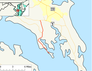
Maryland Route 249 is a state highway in the U.S. state of Maryland. Known as Piney Point Road, the state highway runs 9.84 miles (15.84 km) from St. George Island north to MD 5 in Callaway. MD 249 is the primary access to St. George Island and the communities of Piney Point, Tall Timbers, and Valley Lee on the Piney Point peninsula between the Potomac River and St. George's Creek in southern St. Mary's County. The state highway was constructed on the mainland in the early 1920s; the portion of the highway on St. George Island was completed in the early 1930s. MD 249 was reconstructed in the 1950s, including a new St. George Island Bridge.
Tall Timbers, Maryland may refer to:

Tall Timber is an unincorporated community and a census-designated place (CDP) located in and governed by Boulder County, Colorado, United States. The CDP is a part of the Boulder, CO Metropolitan Statistical Area. The population of the Tall Timber CDP was 208 at the United States Census 2010. The Boulder post office serves the area.

St. Mary is a home rule-class city in Marion County, Kentucky, in the United States. During the 2010 U.S. Census, the Saint Mary Division of Marion Co. – covering 34.3 square miles (89 km2) around the city – had a population of 2,765.
Wildewood is a planned community and census-designated place (CDP) in St. Mary's County, Maryland, United States. It is in east-central St. Mary's County, 7 miles (11 km) east of Leonardtown, the county seat, and 58 miles (93 km) southeast of Washington, D.C. It is bordered to the east by the unincorporated community of California.


