
Porvoo is a city in Finland. It is located on the south coast of the country, on the Gulf of Finland. Porvoo lies in the eastern part of the Uusimaa region. The population of Porvoo is approximately 52,000, while the sub-region has a population of approximately 60,000. It is the 19th most populous municipality in Finland, and the 15th most populous urban area in the country.
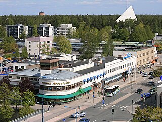
Tampere is a city in Finland and the regional capital of Pirkanmaa. It is located in the Finnish Lakeland. The population of Tampere is approximately 259,000, while the metropolitan area has a population of approximately 421,000. It is the 3rd most populous municipality in Finland, and the second most populous urban area in the country after the Helsinki metropolitan area.

Finland attracted over 6.8 million foreign tourists in 2018, with 53 percent coming from other European Union states. In 2017, the value added by tourism was about 4.6 billion euros, or 2.6% of the Finnish GDP, providing approximately 140,200 jobs.

Lempäälä is a municipality in Finland, located in the Pirkanmaa region. It lies south of the regional capital, Tampere. The population of Lempäälä is approximately 25,000, while the metropolitan area has a population of approximately 421,000. It is the 41st most populous municipality in Finland.

Nokia is a town in the Pirkanmaa region of Finland. It lies on the banks of the Nokianvirta, a river of the Kokemäki River watershed, and is situated in the Tampere metropolitan area, about 15 kilometres (9 mi) west of Tampere proper. The population of Nokia is approximately 36,000, while the Tampere metropolitan area has a population of approximately 421,000. It is the 33rd most populous municipality in Finland, and the second largest in the Pirkanmaa region after Tampere.
The municipalities represent the local level of administration in Finland and act as the fundamental, self-governing administrative units of the country. The entire country is incorporated into municipalities and legally, all municipalities are equal, although certain municipalities are called cities or towns. Municipalities have the right to levy a flat percentual income tax, which is between 16 and 22 percent, and they provide two thirds of public services. Municipalities control many community services, such as schools, health care and the water supply, and local streets. They do not maintain highways, set laws or keep police forces, which are responsibilities of the central government.

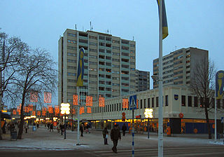
Lahti is a city in Finland and the regional capital of Päijät-Häme. It is located in the Finnish Lakeland. The population of Lahti is approximately 121,000, while the sub-region has a population of approximately 205,000. It is the 9th most populous municipality in Finland, and the sixth most populous urban area in the country.

Forssa is a town and municipality of Finland. It is located almost in the centre of a triangle defined by the three largest major cities in Finland, in the Tavastia Proper region, and which is crossed by Highway 2 between Pori and Helsinki and Highway 10 between Turku and Hämeenlinna. The town has a population of 16,450 and covers an area of 253.38 square kilometres (97.83 sq mi) of which 4.61 km2 (1.78 sq mi) is water. The population density is 66.11 inhabitants per square kilometre (171.2/sq mi). Only a little part of the surface area of Forssa is water, but the river Loimijoki forms an important element in the cityscape, with the city being located at its starting point. Other notable water areas in Forssa include the lake Kaukjärvi and the lake Koijärvi, known as the birthplace of the Green League.
Hyvinkää is a town in Finland, located in the southern interior of the country. Hyvinkää is situated in the northern part of the Uusimaa region. The population of Hyvinkää is approximately 47,000. It is the 23rd most populous municipality in Finland. Hyvinkää is part of the Helsinki Metropolitan Area, which has approximately 1.6 million inhabitants.

Southwest Finland, calqued as Finland Proper, is a region in the southwest of Finland. It borders the regions of Satakunta, Pirkanmaa, Tavastia Proper (Kanta-Häme), Uusimaa, and Åland. The region's capital and most populous city is Turku, which was the capital city of Finland before Helsinki.

Pirkanmaa, also known as Tampere Region in government documents, is a region of Finland. It borders the regions of Satakunta, South Ostrobothnia, Central Finland, Päijät-Häme, Kanta-Häme and Southwest Finland. Most of the water area in the Kokemäki River watershed is located in the Pirkanmaa region, although Lake Vanajavesi is partly in the Kanta-Häme region. The region got its name from Pirkkala, which in the Middle Ages comprised most of present-day Pirkanmaa. Tampere is the regional center and capital of Pirkanmaa, and at the same time the largest city in the region.
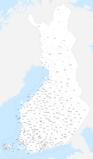
Sub-regions are divisions used for statistical purposes in Finland. The country is divided into 69 sub-regions, which are formed by groups of municipalities within the 19 regions of Finland. These sub-regions represent a LAU 1 level of division used in conjunction with the Nomenclature of Territorial Units for Statistics.

Ylöjärvi is a town in Finland, located in the Pirkanmaa region. It lies to the west of the regional capital, Tampere. The population of Ylöjärvi is approximately 34,000, while the metropolitan area has a population of approximately 421,000. It is the 35th most populous municipality in Finland, and the third largest in the Pirkanmaa region after Tampere and Nokia.
Kerava is a town in Finland, located in the southern interior of the country. Kerava is situated in the centre of the Uusimaa region. The population of Kerava is approximately 38,000. It is the 30th most populous municipality in Finland. Kerava is part of the Helsinki Metropolitan Area, which has approximately 1.6 million inhabitants.

Orivesi is a town in Finland, located in the Pirkanmaa region. It lies to the northeast of the regional capital, Tampere. The population of Orivesi is approximately 9,000, while the metropolitan area has a population of approximately 421,000. It is the 111th most populous municipality in Finland.
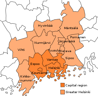
Helsinki metropolitan area or Greater Helsinki is the metropolitan area around Helsinki, the capital city of Finland. It also includes the smaller capital region. The terms Helsinki metropolitan area, Greater Helsinki, Capital region and the other terms used are not fixed and may vary in different contexts.
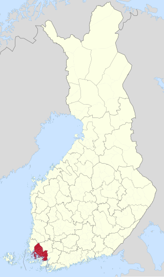
Turku sub-region is a subdivision of Southwest Finland in Finland. It is the third most populous sub-region in Finland with about 350,000 inhabitants after Helsinki and Tampere. The sub-regions are used for statistical purposes. Statistics Finland uses the term Turku sub-region as SK023 Turku.
Helsinki sub-region is a subdivision of Uusimaa in Finland. It is the most populous sub-region in Finland with about 1.66 million inhabitants. The sub-regions are used for statistical purposes. Statistics Finland uses the term Helsinki sub-region as SK011 Helsinki. The Lohja sub-region was merged with the Helsinki sub-region in 2009.

Turku metropolitan area or Turku region is the metropolitan area around the city of Turku in Finland. The joint municipal authority of the Turku city region consists of six municipalities: Turku, Kaarina, Lieto, Naantali, Raisio and Rusko. The Turku metropolitan area forms a compact, urban-like regional growth centre where people commute from a relatively large area of the Southwest Finland region.

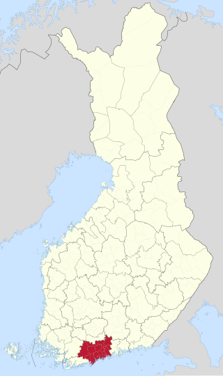
Tampere metropolitan area or Tampere region is the metropolitan area around the city of Tampere in Finland. The joint municipal authority of the Tampere city region consists of eight municipalities: Tampere, Kangasala, Lempäälä, Nokia, Orivesi, Pirkkala, Vesilahti and Ylöjärvi. The Tampere metropolitan area forms a compact, urban-like regional growth centre where people commute from a relatively large area of the Pirkanmaa region.


