Related Research Articles

The Faroe Islands is served by an internal transport system based on roads, ferries, and helicopters. As of the 1970s, the majority of the population centres of the Faroe Islands have been joined to a single road network, connected by bridges and tunnels.

Streymoy is the largest and most populated island of the Faroe Islands. The capital, Tórshavn, is located on its southeast coast. The name means "island of currents". It also refers to the largest region of the country that also includes the islands of Hestur, Koltur and Nólsoy.

Eysturoy is a region and the second-largest of the Faroe Islands, both in size and population.

Tórshavn Municipality is the municipality of the Faroese capital Tórshavn and its surroundings.

Strandfaraskip Landsins is the government agency for public transport in the Faroe Islands. It is owned by the Faroese national government under the Ministry of Finance (Fíggjamálaráðið) and runs seven ferry routes and a number of bus routes.

Sunda is a municipality in the Faroe Islands, loosely centered around the Sundini sound between the islands of Streymoy and Eysturoy.
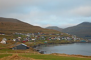
Saltangará is a village in the Faroe Islands, on the island of Eysturoy.

Kollafjørður is a village in the Faroe Islands, located on the island of Streymoy. As of 1. January 2024, the village had a population of 813. Its postal code is FO 410. Until 2001 it was a municipality in its own right but is now part of the Tórshavn Municipality. It is located 21.8 kilometres (13.5 mi) by road north of Tórshavn, and stretches 7 km (4.3 mi) along the fjord of the same name.
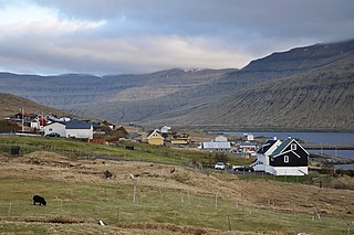
Oyrarbakki is a village on the west coast of the Faroese island of Eysturoy in the Sunda municipality, between Norðskáli and Oyri.
Strendur is a village on the Faroese island of Eysturoy, located along the Skálafjørður fjord. It is the seat and main settlement of the Sjóvar Municipality.
SEV is a power producer and distributor on the Faroe Islands. The company name is derived from the names of islands Streymoy, Eysturoy and Vágar, which established the company on 1 October 1946. All municipalities in Vágar, all in Eysturoy except for Sjóvar municipality and all municipalities in Streymoy except for Tórshavn, Kvívík and Kollafjørður met at the first establishing meeting. Later all municipalities in the Faroe Islands joined SEV. In 2015 60% of the produced electricity of SEV came from green energy sources, 17,8% came from the windmills in Neshagi and Húsahagi, 42,3% came was hydropower.

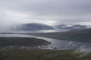
Skálafjørður is a fjord in Eysturoy and the longest in the Faroe Islands.

Eysturoyartunnilin is a large undersea road tunnel under the Tangafjørður sound in the Faroe Islands, connecting the island of Streymoy to the island of Eysturoy. It also crosses the southern part of Skálafjørður, and connects the towns of Runavík on the eastern side and Strendur on the western side of the fjord, and includes the world's first undersea roundabout in the middle of the network.

Sandoyartunnilin is an undersea road tunnel in the Faroe Islands. It connects the main island of Streymoy with Sandoy to the south. The length of the tunnel is 10.8 kilometres (6.7 mi) and the estimated cost is 860 million DKK. The tunnel opened for traffic on 21 December 2023, after which the ferry Teistin ceased its route between Gamlarætt on Streymoy and Skopun on Sandoy. The tunnel crosses the Skopunarfjørður and runs from Gamlarætt to Traðardalur in central Sandoy, near the Inni í Dal stadium.

Jógvan Poulsen was a Faroese teacher and writer, and a politician for the Union Party.

The Streymin Bridge, is an important highway bridge in the Faroe Islands. It connects the two biggest and most populous islands of Streymoy to the west and Eysturoy to the east. Crossing the Sundini sound at its narrowest point, it is jokingly referred to as the 'Bridge over the Atlantic', being the only inter-island bridge in the Faroe Islands, and one of the few such bridges in the Atlantic Ocean.

Sundini is the northern section of the sound separating the islands of Streymoy and Eysturoy in the Faroe Islands. The southern section of the strait is named Tangafjørður.

Skopunarfjørður is a strait separating Sandoy and Streymoy in the Faroe Islands. The strait also passes the isle of Hestur.
The Faroe Islands consist of 18 islands, several of which are deeply incised by fjords.
References
- ↑ Sprotin.fo. "sund". Sprotin.fo (in Faroese). Retrieved 2020-11-22.
- ↑ Guttesen, Rolf (1996). The Faeroe Islands Topographic Atlas. Copenhagen: Royal Danish Geographical Society and Kort- & Matrikelstyrelsen.
- 1 2 "Kortal". www.kortal.fo. Retrieved 2020-11-22.
- ↑ "Kortal.fo".
- ↑ "Amended finance law 2003-2".
- ↑ Árbók fyri Føroyar 2003. Hagstova Føroya. 2004. p. 183. ISBN 99918-0-346-7.
- ↑ "Alistøðir á sjónum" [Alistóðir on the sea] (in Icelandic). 2015-01-13.
- ↑ "Landsverk" (in Icelandic). Retrieved 2020-11-22.
- ↑ "Eysturoyartunnilin". Eystur- og Sandoyatunlar. Retrieved 2020-11-22.
- ↑ "Pendling | Hagstova Føroya". hagstova.fo. Retrieved 2020-11-22.