According to historian Fortunato Zora Carvajal[es], there are several possible origins for the area's name. Historian Rómulo Cúneo y Vidal proposed that its name came from union of Tara, the name of a local plant, and the suffix -ta, which means place. The suffix would have been added by the mitimaes, Indians forcibly resettled by the policy of the same name of the Inca Empire. Several other proposals exist.
History
The archaeological work of Rogger Ravines in Karu cave demonstrates an early settlement of the area, possibly dating back to 7000 BC. The oldest human settlement discovered in the province is the Kano site, located a few km from the city. The petroglyphs and cave paintings found there are contemporary with this site. The cave paintings are found exclusively in grottos or caves. The ancient inhabitants of Tarata created their drawings primarily using red ochre clay, although there are also, to a lesser extent, paintings using yellow ochre. The cave paintings of Sitajara, Susapaya, and Talabaya are particularly noteworthy.[1]
The petroglyphs are notable for their depictions of local fauna, hunting scenes, and geometric figures such as circles and spirals. Interpreting these drawings is sometimes difficult because the worldview of prehistoric humans differed from that of modern Andean people. Petroglyph fields can be found in Sujilbaya, Koropuro, Qhanajiri, and Mocara, and also in Estique-pampa and Ticaco.[1]
The Tiahuanaco culture was centered on the Collao Plateau, specifically in the city of Tiwanaku, more than 170 km northeast of Tarata. This culture possessed extensive knowledge of agricultural techniques and a complex religious system. After its fall, the Aymara kingdoms exerted the greatest influence in the region. So much so that Tarata, which today belongs to the Aymara region of southern Peru, was inhabited by the Lupaqha or Lupaca Aymara people, whose memory still endures in place names and surnames. The Lupaqha arrived at the beginning of the Late Intermediate Period, approximately between 1100 and 1200 CE. Their presence was predominant until the Inca conquest and the annexation of the territory to the Inca Empire.
Rómulo Cúneo y Vidal states that the Aymara people who inhabited Tarata, Putina, and Sama came from the town of Pomata, on the shores of Lake Titicaca, which, along with Chucuito, Juli, Ilave, Acora, Zepita, and Yunguyo, formed the great Aymara chiefdom of Chucuito. Even during the colonial period, the chiefs of Pomata, Tarata, Putina, and Sama were the Champilla clan, and this remained the case until 1625. During the rest of the colonial period, the ancient Lupaca lineages of Tarata regained their autonomy over the chiefs of the highlands.
Inca and Spanish period
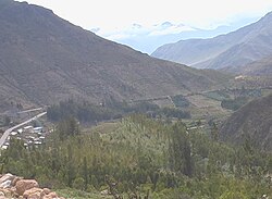
The Incas arrived in Tarata in the mid-15th century, annexing it to their empire and naming their territory Yunka. The Incas organized the locals into distinct territories, evidenced by two irrigation systems that remain to this day: Lupaqa, south of the Chacavira River, and Yunka, north of the Chacavira River. The arrival of the Inca culture indicates a reorganization of power and political structure. The territory of Tarata was included within a territorial division called Kolisuyu, which extended from Camaná to San Pedro de Atacama.[1]
Inca architecture is reflected in the construction of various settlements throughout the province. One of the best preserved is the archaeological complex now known as Santa María, located a short distance from Tarata. It is believed to be an Inca tambo attached to the Inca road system, occupying an area of 4,000 m² (100 x 40 meters) at an altitude of 3,082 meters above sea level. Santa María is situated on the edge of a ravine and features trapezoidal niches characteristic of Inca culture. The complex includes rooms, agricultural terraces, and an internal street.[1]
The section of the Inca road through the province of Tarata is an undeniable testament to this civilization's presence in the region, connecting the diverse ecological zones within the province and serving as a means of transportation for the people of Tarata even into the 20th century. The road in Tarata was crucial for the complete integration of the area into the Inca Empire and the exchange of agricultural products. In Tarata, a longitudinal Inca road connects the towns of Estique, Tarata, Ticaco, Sitajara, and Susapaya, continuing into the province of Candarave. There are also other transverse sections branching off from this longitudinal road, connecting Tarata with towns on the coast and the Collao Plateau. Along the Inca road that crosses the province of Tarata, there is also a tambo called Chajlaka, located in the town of Sitajara.[1]
Under the Spanish Empire, Tarata was an important indigenous center, as evidenced by its churches and other colonial buildings. The original town was founded on January 3, 1741. In 1811, hundreds of local Indians under the command of chief Kopaja took part in Francisco de Zela's armed rebellion in Tacna, which was ultimately suppressed.
Republican period
The district of Tarata was created by Simón Bolívar in 1824. On November 12, 1874, Manuel Pardo created the province by law, integrated by the districts of Estique, Tarucachi, Ticaco y Candarave. In 1880, Tarata was occupied by Chilean troops during the War of the Pacific. Following the 1883 Treaty of Ancón, it was incorporated into the department of Tarata, a subdivision of the province of Tacna, a first-level administrative division created by Chile in 1883 to administer the disputed territory.
Unlike the provinces of Tacna and Arica, the incorporation of this territory was disputed by Peru, as both countries differed in their interpretation of the Sama River's course, which served as the temporary border between Peru and Chile. Furthermore, the creation of the department of Tarata in 1911 aggravated the dispute, which concluded with the department's disestablishment on September 22, 1921, and the return of Tarata to Peru on September 1, 1925. The mediation of U.S. President Calvin Coolidge was significant in the conclusion of the 42-year dispute, known locally as the captivity of Tarata (Spanish: cautiverio de Tarata).
Contemporary period
Following the province's return to Peru, it was again administered as a subdivision of "Free Tacna" (Tacna libre), the official desgination since 1890 of the unoccupied area of the department of the same name.
The province is inhabited by indigenous citizens of Aymara descent. Spanish, however, is the language which the majority of the population (82.31%) learnt to speak in childhood, 17.12% of the residents started speaking using the Aymara language (2007 Peru Census).[3]
This page is based on this Wikipedia article Text is available under the CC BY-SA 4.0 license; additional terms may apply. Images, videos and audio are available under their respective licenses.