Tarryall, Colorado

Last updated
Tarryall, Colorado
Town
Schoolhouse Tarryall CO.jpg
Tarryall School is listed on the National Register of Historic Places
Coordinates: 39°07′19″N105°28′32″W / 39.12194°N 105.47556°W / 39.12194; -105.47556
Country Flag of the United States.svg  United States
State Flag of Colorado.svg  Colorado
Counties Park
Founded1896
Elevation
[1]
8,714 ft (2,656 m)
Time zone UTC-7 (MST)
  Summer (DST) UTC-6 (MDT)
ZIP code [2]
80827 (Lake George)
GNIS feature ID183832 [1]

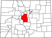
Tarryall is an unincorporated town eastern Park County, Colorado, United States. The town is located on Tarryall Creek in the eastern edge of the South Park, between Lake George and Jefferson.

Contents

History

Puma City, 1898 Tarryall, Colorado - 1898.jpg
Puma City, 1898

The town was founded in 1896 as Puma City, in response to mineral discoveries in the area. Within its first year, it reached a peak population of about a thousand residents. The Tarryall Post Office soon opened to serve the town. The population dwindled as the mineral discoveries proved to be much smaller than first thought. In the 1900s, the town took the name of its post office, Tarryall. [3] Only a handful of residents remain.

Related Research Articles

<span class="mw-page-title-main">Leadville, Colorado</span> City in Colorado, United States

Leadville is a statutory city that is the county seat, the most populous community, and the only incorporated municipality in Lake County, Colorado, United States. The city population was 2,633 at the 2020 census. It is situated at an elevation of 10,158 feet (3,096 m). Leadville is the third highest incorporated city in the United States behind Alma and Montezuma and is surrounded by two of the tallest peaks in the state.

<span class="mw-page-title-main">Park County, Colorado</span> County in Colorado, United States

Park County is a county located in the U.S. state of Colorado. As of the 2020 census, the population was 17,390. The county seat is Fairplay. The county was named after the large geographic region known as South Park, which was named by early fur traders and trappers in the area.

<span class="mw-page-title-main">Ehrenberg, Arizona</span> CDP and ghost town in La Paz County, Arizona

Ehrenberg, also historically spelled "Ehrenburg", is an unincorporated community and census-designated place (CDP) in La Paz County, Arizona, United States. The population was 1,470 at the 2010 census. Ehrenberg is named for its founder, Herman Ehrenberg.

<span class="mw-page-title-main">Montezuma, Colorado</span> Town in Colorado, United States

The Town of Montezuma is a statutory town located in eastern Summit County, Colorado, United States. The town population was 74 at 2020 United States Census. The town is a former mining camp that sits at an elevation of 10,200 feet (3,110 m), just west of the Continental Divide, nestled among mountains that reach an elevation of 12,000-13,000 feet around it. It is situated in the upper valley of the Snake River above the ski resort of Keystone in the Rocky Mountains.

<span class="mw-page-title-main">Ashcroft, Colorado</span> United States historic place

Ashcroft is an extinct mining town located in Pitkin County, Colorado, United States. The silver mining camp was founded as Castle Forks City in the spring of 1880. A post office named Ashcroft operated at the site from August 12, 1880, until August 5, 1881, when the name was changed to Chloride. The Chloride post office operated until January 3, 1882 when the name was changed back to Ashcroft. The renamed Ashcroft post office finally closed on November 30, 1912.

<span class="mw-page-title-main">Guffey, Colorado</span> Census-designated place in Park County, Colorado, United States

Guffey is a census-designated place (CDP) and post office in and governed by Park County, Colorado, United States. The Guffey post office has the ZIP Code 80820. At the United States Census 2020, the population of the Guffey CDP was 111. The CDP is a part of the Denver–Aurora–Lakewood, CO Metropolitan Statistical Area.

<span class="mw-page-title-main">History of Colorado Springs, Colorado</span> Place in Colorado, United States

Before it was founded, the site of modern-day Colorado Springs, Colorado, was part of the American frontier. Old Colorado City, built in 1859 during the Pike's Peak Gold Rush was the Colorado Territory capital. The town of Colorado Springs was founded by General William Jackson Palmer as a resort town. Old Colorado City was annexed into Colorado Springs. Railroads brought tourists and visitors to the area from other parts of the United States and abroad. The city was noted for junctions for seven railways: Denver and Rio Grande (1870), Denver and New Orleans Manitou Branch (1882), Colorado Midland (1886-1918), Colorado Springs and Interurban, Atchison, Topeka, and Santa Fe (1889), Rock Island (1889), and Colorado Springs and Cripple Creek Railways. It was also known for mining exchanges and brokers for the Cripple Creek Gold Rush.

Gold mining in Colorado, a state of the United States, has been an industry since 1858. It also played a key role in the establishment of the state of Colorado.

<span class="mw-page-title-main">Oro City, Colorado</span> Ghost town in Lake County, Colorado, United States

Oro City is a ghost town in Lake County, Colorado, United States

Tarryall is a ghost town in northwest Park County, Colorado, United States. It is on upper Tarryall Creek northwest of Como, Colorado. It was once the county seat of Park County, but is now completely deserted.

<span class="mw-page-title-main">Buckskin Joe, Park County, Colorado</span>

Buckskin Joe is an extinct gold mining town located in Park County, Colorado, United States. The town was founded in 1860 as Laurette in what was then the Kansas Territory. The Territory of Colorado was created on February 28, 1861, and the Laurette post office opened on November 14, 1861. Laurette was elected the Park County seat on January 7, 1862. The post office name was changed to Buckskin on December 21, 1865, although the town was popularly known as Buckskin Joe. The county seat was moved to Fair Play in 1867, and the Buckskin post office closed on January 24, 1873.

<span class="mw-page-title-main">Independence, Pitkin County, Colorado</span> Ghost town in Colorado, United States

Independence is an extinct town located in Pitkin County, Colorado, United States. It is located at an elevation of 10,913 feet (3,326 m) 2.2 miles (3.6 km) directly west of Independence Pass. It was the first settlement established in the Roaring Fork Valley, after gold was struck in the vicinity on Independence Day, July 4, 1879, hence its name. Independence was served by three differently named post offices: Farwell from July 14, 1881, until July 3, 1882; Sparkill from February 1, 1882, until October 18, 1887; and Chipeta from April 20, 1899, until October 17, 1899. It has also been known historically as Mammoth City, Mount Hope, and Hunter's Pass.

Diamond is a ghost town in eastern Juab County, Utah, United States. The Diamond Cemetery is listed on the National Register of Historic Places.

<span class="mw-page-title-main">Red Mountain Town, Colorado</span> Ghost town in Ouray County, Colorado

Red Mountain Town is a silver mining ghost town in Ouray County, Colorado, United States, south of Ouray along the "Million Dollar Highway".

References

  1. 1 2 U.S. Geological Survey Geographic Names Information System: Tarryall, Colorado
  2. "ZIP Code Lookup" (JavaScript/HTML). United States Postal Service . Retrieved September 13, 2007.
  3. Robert L. Brown, 2003, Ghost towns of the Colorado Rockies, Caxton Press, ISBN   0-87004-342-0, p.286-290