
Park County is a county located in the U.S. state of Colorado. As of the 2020 census, the population was 17,390. The county seat is Fairplay. The county was named after the large geographic region known as South Park, which was named by early fur traders and trappers in the area.

Ordway is a Statutory Town in and the county seat of Crowley County, Colorado, United States, that is also the most populous community in the county. The population was 1,066 at the 2020 census.

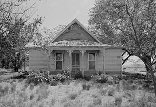
Como is an unincorporated community in Park County in the Rocky Mountains of central Colorado, United States. According to the 2010 census, the population of zip code 80432 is 439, including surrounding subdivisions in a 15 mile radius. Metropolitan Como proper usually has a population of 12 to 15 residents, within the Como plat.
Dallas is an extinct town in Ouray County, Colorado, United States. Also known as Dallas City, it lay about 3 miles (4.8 km) north of the present town of Ridgway at the confluence of Dallas Creek and the Uncompahgre River. The Dallas post office operated from February 11, 1884, until October 31 1899. A community named in tribute to the historic town bearing the name Dallas Meadows now exists near its historic location.

Dearfield is an extinct town and a historically black majority settlement in Weld County, Colorado, United States. It is 30 miles (48 km) east of Greeley. The town was formed by Oliver Toussaint Jackson, who desired to create a colony for African Americans. In 1910, Jackson, a successful businessman from Boulder, filed on the homestead that later became the town and began to advertise for "colonists." The name Dearfield was suggested by one of the town's citizens, Dr. J.H.P. Westbrook, who was from Denver. The word dear was chosen as the foundation for the town's name due to the precious value of the land and community to the town's settlers.
Dakan was a short-lived mining town, now a ghost town, in western Douglas County, Colorado, United States, in the Front Range of the Rocky Mountains. The Dakan post office operated from December 30, 1896, until August 2, 1898.

Fort Saint Vrain was an 1837 fur trading post built by the Bent, St. Vrain Company, and located at the confluence of Saint Vrain Creek and the South Platte River, about 20 miles (32 km) east of the Rocky Mountains in the unorganized territory of the United States, in present-day Weld County, Colorado. A historical marker notes the place where Old Fort St. Vrain once stood, today at the end of Weld County Road 40, located about seven miles north of Fort Vasquez, Colorado. Among those who helped to establish the fort was Ceran St. Vrain, after whom it was named.
Tarryall is a ghost town in northwest Park County, Colorado, United States. It is on upper Tarryall Creek northwest of Como, Colorado. It was once the county seat of Park County, but is now completely deserted.

Buckskin Joe is an extinct gold mining town located in Park County, Colorado, United States. The town was founded in 1860 as Laurette in what was then the Kansas Territory. The Territory of Colorado was created on February 28, 1861, and the Laurette post office opened on November 14, 1861. Laurette was elected the Park County seat on January 7, 1862. The post office name was changed to Buckskin on December 21, 1865, although the town was popularly known as Buckskin Joe. The county seat was moved to Fair Play in 1867, and the Buckskin post office closed on January 24, 1873.
Madrid is a ghost town in Las Animas County, Colorado, United States. It is east of the Front Range of the Rocky Mountains at an elevation of 6,590 feet (2,010 m). The town is the west side of the county along State Highway 12, fourteen miles (23 km) west of Trinidad. Madrid is named for Hilario Madrid, who settled there in the 19th century from New Mexico, not after Spain's capital. Originally called Madrid Plaza, it was established as a settler's post in 1864. Hilario and his brother Juan Madrid homesteaded there in September 1879. There was a Post Office in the town from 1882 to 1917.

Independence is an extinct town located in Pitkin County, Colorado, United States. It is located at an elevation of 10,913 feet (3,326 m) 2.2 miles (3.6 km) directly west of Independence Pass. It was the first settlement established in the Roaring Fork Valley, after gold was struck in the vicinity on Independence Day, July 4, 1879, hence its name. Independence was served by three differently named post offices: Farwell from July 14, 1881, until July 3, 1882; Sparkill from February 1, 1882, until October 18, 1887; and Chipeta from April 20, 1899, until October 17, 1899. It has also been known historically as Mammoth City, Mount Hope, and Hunter's Pass.
Chandler is an extinct coal company town located south of the Lincoln Park area near Cañon City in Fremont County, Colorado, United States. The Chandler post office operated from August 4, 1890, until October 31, 1942.

Brodhead is an extinct coal mining town located in Las Animas County, Colorado, United States. The townsite is located at 37.4108°N 104.6764°W at an elevation of 6,919 feet (2,109 m). The Brodhead post office operated from August 14, 1902, until April 29, 1939.

Bowen is an extinct town located in Las Animas County, Colorado, United States.

Hahns Peak Village is an unincorporated community in Routt County, Colorado, United States. The village is located 7 miles (11 km) north of Clark on Routt County Road 129, and 0.5 miles (0.8 km) east-southeast of Steamboat Lake State Park. The community is named for Hahns Peak, which 2.7 miles (4.3 km) north-northeast.
Adelaide is an extinct mining town located in Lake County, Colorado, United States. The site of the former town is located about one mile west of downtown Leadville through Stray Horse Gulch and two-thirds of a mile north of Nugget Gulch.
Baldwin is an extinct coal mining town located in Gunnison County, Colorado, United States. The townsite is located at 38.7639°N 107.0478°W at an elevation of 8,767 feet (2,672 m). The Baldwin post office operated from September 17, 1883, until September 30, 1948.
Clarkville is a ghost town located in northern Yuma County, Colorado, United States. Founded in 1933, the townsite is located at an intersection where Colorado State Highway 59 curves from East-West to North-South. The Clarkville post office operated from May 18, 1938, until April 30, 1954.

Guston is a silver mining ghost town in Ouray County, Colorado, United States, 11 miles (18 km) south of Ouray following the "Million Dollar Highway". Nestled in Champion Gulch, it is located near Red Mountain and the remnants of Red Mountain Town and Ironton. The Silverton Railroad ran from Guston in the Red Mountain Pass to Silverton in San Juan County. The silver mining camp was established in 1883. The Guston post office operated from January 26, 1892, until November 16, 1898.


