Como, Colorado | |
|---|---|
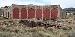 The Como Roundhouse handled repairs on the railroads until 1937. In 1938, the remaining tracks were removed. | |
 Como Location of Como, Colorado.  Como Como (Colorado) | |
| Coordinates: 39°18′58″N105°53′34″W / 39.3161°N 105.8928°W [1] | |
| Country | United States |
| State | Colorado |
| County | Park [2] |
| Government | |
| • Type | unincorporated community |
| • Body | Park County [2] |
| Elevation | 9,813 ft (2,991 m) |
| Population (2010) | |
• Total | 439 |
| Time zone | UTC−07:00 (MST) |
| • Summer (DST) | UTC−06:00 (MDT) |
| ZIP code [3] | 80432 |
| Area code | 719 |
| GNIS place ID | 183395 |
Como is an unincorporated community in Park County in the Rocky Mountains of central Colorado, United States. According to the 2010 census, the population of zip code 80432 is 439, including surrounding subdivisions in a 15-mile radius. Metropolitan Como proper usually has a population of 12 to 15 residents, within the Como plat. [4]


