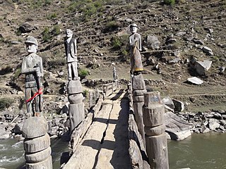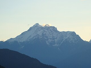
Bajura District, a part of Province No. 7, is one of the seventy-seven districts of Nepal. The district, with Martadi as its district headquarters, covers an area of 2,188 km² and had a population of 108,781 in 2001 and 134,912 in 2011. The district has nine municipalities, 9 Ilakas and 1 constituency areas. The district is situated in Longitude between 81° 10′ 20″ to 81° 48′ 27″ East and Latitude 29° 16′ 21″ to 29° 56′ 56″ North. Geographically the district is divided in three distinct regions from north to south viz. Higher Himalayan Region, Higher Mountain and mid – Mountains. The Higher Himalayan region comprises Saipal Himalayan range; High Mountain region comprises Doha Lekh and Ghori Lekh. Similarly, Mid-Mountain range comprises different ranges of mountains e.g. Badimalika Temple. The District has started from 300m to 6400m in height. The annual rainfall is about 13,433 mm and temperatures vary from 0 °C to 40 °C. The livelihood of more than 80% of the district population depends on agriculture farming, mainly small scale livestock. Due to low level of agricultural production, the majority of the households face acute food shortages for a large part of the year. According to the National Census 2011, the total population of the district is 134,912 comprising 69,106 female (51%) and 65,806 male (49%) residing in 24,908 households. Bajura district has an average population density of around 62 people per square km. The average family size is 5.4. Life expectancy of the people is 58 years. The average literacy rate is about 32%. Bajura district has a multi ethnic composition with Chhetri, Kami, Thakuri, Brahman, Damai, SarkI and Sanyashi. The common language is Nepali (96%) followed by Bhote Sherpa (0.46%) and Tamang (0.42%). Although accessibility to Bajura is very poor, this is improving rapidly. The Government strategy is mainly focused on the connection of VDC headquarters with all-weather motor able roads to SRN or District headquarters. Moreover, the DDC body of Bajura district has given higher priority on rural roads.

Jumla District, a part of Karnali province, is one out of ten districts of Karnali. The district, with Jumla as its district headquarters, covers an area of 2,531 square kilometres (977 sq mi) and had a population of 89,427 in 2001 Nepal census and 108,921 in 2011 Nepal census. Jumla is situated in Longitude between 81⁰ 28' E to 82⁰ 18'East and Latitude between 28⁰ 58'N to 29⁰ 30'North.

Myagdi District, a part of Gandaki Pradesh, is one of the seventy-seven districts of Nepal. The district, with Beni as its district headquarters, covers an area of 2,297 km², had a population of 114,447 in 2001 and 113,641 in 2011.

Rasuwa District(Nepali: रसुवा जिल्लाListen , a part of Province No. 3, is one of the seventy-five districts of Nepal, a landlocked country Nepal, South Asia. The district, with Dhunche as its district headquarters, covers an area of 1,544 km² and has a population of 43,300. As per census 2011 total households in Rasuwa district is 9,778.

Bahrabise is a city in Sindhupalchok District in the Bagmati Zone of central Nepal. It consists of nine wards.

Phulpingkot is a village in Sindhupalchok District in the Bagmati Zone of central Nepal. At the time of the 1991 Nepal census it had a population of 3714 and had 773 houses in the village. It has been divided into 9 wards. This VDC is attached to a famous marketplace in Sindhupalchok called Jalbire. People in this district have different ethnicity and religions. The neighboring VDCs are Jalbire, Hagam, Phulpingdada, Maneshwara and Bataase. People are involved in agriculture for living. Almost all of the people are in below poverty line. Many have been working in foreign soil for the survival of their family. Famous poet of Sindhupalchok District, Chandra Prasad Neupane is from this VDC.

Melamchi is a municipality in Sindhupalchok District in the Bagmati Zone of central Nepal. At the time of the 1991 Nepal census it had a population of 3936 and had 710 houses in the village.

Sangachok is a village and market center of Chautara Sangachowkgadi Municipality in Sindhupalchok District in the Bagmati Zone of central Nepal. The formerly Village Development Committee was merged to form the new municipality on 2017. At the time of the 2013 Nepal census it had a population of 10,791 and had 1,828 houses in the village.

Thumpakhar is a village in Sindhupalchok District in the Bagmati Zone of central Nepal. In the 1991 Nepal census, it had a population of 5210, with 1023 houses.

Indreshwar is a village development committee in Kabhrepalanchok District in the Bagmati Zone of central Nepal. At the time of the 1991 Nepal census it had a population of 3878 and had 659 houses in it.

Bhardeu is a village and former Village Development Committee that is now part of Konjyosom Rural Municipality in Province No. 3 of central Nepal. At the time of the 1991 Nepal census it had a population of 1746 in 310 individual households.

Patarasi is a rural municipality located in Jumla District of Karnali Province of Nepal.

Agni Prasad Sapkota is a Nepalese patriotic politician. He hails from a low-middle-class peasant family of Sindhupalchok District, Nepal.

Gaurishankar Conservation Area is a protected area in the Himalayas of Nepal that was established in January 2010, covering 2,179 km2 (841 sq mi) in the Ramechhap, Dolakha and Sindhupalchok districts and encompassing 22 Village Development Committees. It is contiguous with Tibet in the north. The protected area connects the Langtang and Sagarmatha National Parks. The Government of Nepal handed over the management of Gaurishankar Conservation Area to National Trust for Nature Conservation (NTNC) for 20 years in 2010. Following the models of Annapurna and Manaslu Conservation Areas, NTNC has been managing the area through its Gaurishankar Conservation Area Project.

Thumpakhar is a village in Sindhupalchok District in the Bagmati Zone of central Nepal. In the 1991 Nepal census, it had a population of 5210, with 1023 houses.

On August 2, 2014, due to heavy rainfall, a landslide occurred at the Sunkoshi river, killing 156 people and blocking the river to form an artificial lake in Sindhupalchok District, Nepal. Araniko Highway, the main artery of goods and people flow to China, was blocked by the landslide ripping out 5 km of highway, and causing huge traffic jam. 2 dozens houses have been swept by the landslide. The landslide had a volume of 5.5 million cubic metres.

Palungtar is a municipality in Gorkha District in Province No. 4 of Nepal. It is made up of the seven former Village Development Committees Aanppipal, Chyangli, Dhuwakot, Gaikhur, Khoplang, Mirkot and Palumtar. It lies on the bank of Marshyangdi River. The Government of Nepal plans to make Palungtar the country's first Smart City. At the time of the 2011 Nepal census it had a population of 38,174 people living in 9,924 individual households.

Chaudandigadhi is a municipality in Udayapur District of Province No. 1 in Nepal that was established on 10 March 2017 by merging the former Village development committees Chaudandi, Sithdipur, Hadiya and Sundarpur with the former municipality Beltar Basaha. At the time of the 2011 Nepal census, the localities out of which Chaudandigadhi would be formed had a joint population of 48,574 people living in 10,519 individual households. It is surrounded by Belka Municipality in the east, Triyuga in the west, the districts of Khotang and Bhojpur in the north and Sunsari District in the south.

Panchapuri is an urban municipality located in Surkhet District of Karnali Province of Nepal.


