Related Research Articles
The Chalcolithic was an archaeological period characterized by the increasing use of smelted copper. It followed the Neolithic and preceded the Bronze Age. It occurred at different periods in different areas, but was absent in some parts of the world, such as Russia, where there was no well-defined Copper Age between the Stone and Bronze Ages. Stone tools were still predominantly used during this period.

The Zagros Mountains are a long mountain range in Iran, northern Iraq, and southeastern Turkey. The mountain range has a total length of 1,600 km. The Zagros range begins in northwestern Iran and roughly follows Iran's western border while covering much of southeastern Turkey and northeastern Iraq. From this border region, the range continues southeast to the waters of the Persian Gulf. It spans the southern parts of the Armenian highlands, and the whole length of the western and southwestern Iranian plateau, ending at the Strait of Hormuz. The highest point is Mount Dena, at 4,409 metres (14,465 ft).

In archaeology, a blade is a type of stone tool created by striking a long narrow flake from a stone core. This process of reducing the stone and producing the blades is called lithic reduction. Archaeologists use this process of flintknapping to analyze blades and observe their technological uses for historical purposes.
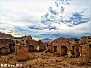
Tepe Sialk is a large ancient archeological site in a suburb of the city of Kashan, Isfahan Province, in central Iran, close to Fin Garden. The culture that inhabited this area has been linked to the Zayandeh River Culture.

The Shulaveri–Shomu culture, also known as the Shulaveri-Shomutepe-Aratashen culture, is an archaeological culture that existed on the territory of present-day Georgia, Azerbaijan, and Armenia, as well as parts of northern Iran during the Late Neolithic/Eneolithic. It lasted from around the end of the seventh millennium BC to the beginning of the fifth millennium BC.

Teppe Zagheh is an early urban settlement located near Qazvin, Iran. In Persian, Tappeh means "tell, mound". It was first excavated by a team from the University of Tehran under the direction of Ezzat Negahban in the early 1970s

The Absheron Peninsula is a peninsula in Azerbaijan. It is the location of Baku, the biggest and the most populous city of the country, and also the Baku metropolitan area, with its satellite cities Sumqayit and Khyrdalan.
Jajrom is a city in the Central District of Jajrom County, North Khorasan province, Iran, serving as capital of both the county and the district.
Tureng Tepe is a Neolithic and Chalcolithic archaeological site in northeastern Iran, in the Gorgan plain, approximately 17 km northeast of the town of Gorgan. Nearby is a village of Turang Tappeh.

Cheshmeh-Ali is an ancient recreational place, located in the south of Tehran and north of Rey or Ray in the country of Iran. The spring is spot in the neighborhood of Ebn-e Babooyeh, Tughrul Tower, and below the Rashkan castle and next to Rey Castle and Fath Ali shah inscription.
Tepe Hissar is a prehistoric site located in the village Heydarabad just south of Damghan in Semnan Province in northeastern Iran.
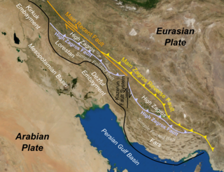
The Zagros fold and thrust belt is an approximately 1,800-kilometre (1,100 mi) long zone of deformed crustal rocks, formed in the foreland of the collision between the Arabian Plate and the Eurasian Plate. It is host to one of the world's largest petroleum provinces, containing about 49% of the established hydrocarbon reserves in fold and thrust belts (FTBs) and about 7% of all reserves globally.
The South Turkmenistan Complex Archaeological Expedition (STACE), also called the South Turkmenistan Archaeological Inter-disciplinary Expedition of the Academy of Sciences of the Turkmen Soviet Socialist Republic (YuTAKE) was endorsed by the Turkmenistan Academy of Sciences. It was initially organized by the orientalist Mikhail Evgenievich Masson in 1946. The expedition had several excavations or "Brigades", based on sites and periods, and were spread over many years.

The main points that are discussed in the geology of Iran include the study of the geological and structural units or zones; stratigraphy; magmatism and igneous rocks; ophiolite series and ultramafic rocks; and orogenic events in Iran.
The 2010 Damghan earthquake occurred in northern Iran at 11:53:49 local time on August 27 with a moment magnitude of 5.8 and maximum Mercalli intensity of VII. This strike-slip event damaged and destroyed a number of small villages in a sparsely populated region near the Alborz mountain range. It left four people dead, 40 injured, and about 800 without homes. The deaths and injuries in this moderate event were attributed to the low-quality construction styles that are typical of the area. The Iranian Strong Motion Network provided data by which seismologists determined the type and extent of the slip as well as the peak ground acceleration. Other large and destructive earthquakes have affected Semnan Province, including several events in 856 AD and 1953.
Trialetian is the name for an Upper Paleolithic-Epipaleolithic stone tool industry from the South Caucasus. It is tentatively dated to the period between 16,000 / 13,000 BP and 8,000 BP.

The Eastern Frontal Fault System is a megaregional system of oblique and thrust faults cross-cutting Colombia from Ecuador in the south to Venezuela in the north. The system from south to north covers ten out of 32 departments of Colombia; Nariño, Putumayo, Cauca, Huila, Caquetá, Cundinamarca, Meta, Boyacá, Casanare and Arauca. The Eastern Frontal Fault System underlies and affects the capitals of Putumayo, Mocoa, Caquetá, Florencia, Meta, Villavicencio and Casanare, Yopal. The fault system has a total length of 921.4 kilometres (572.5 mi) with a cumulative length of the faults of 1,821.8 kilometres (1,132.0 mi) and runs along an average northeast to southwest strike of 042.1 ± 19 bordering and crossing the Eastern Ranges of the Colombian Andes. The fault system forms the boundary between the North Andes microplate and the South American Plate.
Dalma culture was a prehistoric archaeological culture of north-western Iran dating to early fifth millennium B.C. Later, it spread into the central Zagros region and elsewhere in adjacent areas. Its widespread ceramic remains were excavated in central and northern valleys of the Zagros Mountains in north-western Iran. Dalma assemblages were initially discovered by the excavations carried out at Dalma Tepe and Hasanlu Tepe in south-western parts of Lake Urmia, in the valley of Solduz.
The 1977 Bob–Tangol earthquake struck Kerman province of Iran on December 20, 1977, at 03:04 Iran Standard Time. The earthquake measured Mw 5.9 and struck at a depth of 22.7 km (14.1 mi). A maximum Modified Mercalli intensity of VII was evaluated based on damage. It had a strike-slip focal mechanism, which was unusual as the source structure was a thrust fault. It was part of a sequence of strong earthquakes along the 400 km (250 mi) Kuh Banan Fault. Between 584 and 665 people perished while a further 500–1,000 were injured; thousands were also made homeless. Casualties from the earthquake was considered moderate due to the sparsely populated area it affected. Preceded by foreshocks the month before, many residents became wary of a larger earthquake and took refuge outside their homes, contributing to the moderate death toll. However, there were none immediately before the mainshock so many were still in their homes when it struck. Aftershocks were felt for several months, some causing additional damage.
The 1957 Alborz earthquake struck northern Iran's Mazandaran province at 04:12 local time on 2 July. It had a moment magnitude (Mw ) of 7.1 and occurred at a focal depth of 15 km (9.3 mi). The thrust-faulting shock was assigned a maximum Modified Mercalli intensity of IX (Violent). It devastated 120 villages in the Alborz Mountains and caused an estimated 1,500 fatalities. The earthquake also triggered landslides including one that dammed the Haraz River. Some damage was also reported in Tehran, Qaem Shahr and Sari. The total damage was estimated at US$25 million.
References
- 1 2 3 Angela Landgraf, Lucilla Benedetti, Regis Braucher, Didier Bourles et al. Pleistocene deformation and landscape evolution in the Tehran plain: results from tectonic geomorphology and TCN-dating. Geophysical Research Abstracts, Vol. 12, EGU2010-11196, 2010 EGU General Assembly, 2010
- ↑ Gillmore, G.K.; Coningham, R.A.E.; Fazeli, H.; Young, R.L.; Magshoudi, M.; Batt, C.M.; Rushworth, G. (2009). "Irrigation on the Tehran Plain, Iran: Tepe Pardis — The site of a possible Neolithic irrigation feature?". CATENA. 78 (3): 285–300. doi:10.1016/j.catena.2009.02.009.
- ↑ Fazeli, H.; Donahue, R.E; Coningham, R.A.E (2002). "Stone Tool Production, Distribution and use during the Late Neolithic and Chalcolithic on the Tehran Plain, Iran". Iran. 40: 1–14. doi:10.2307/4300616. JSTOR 4300616.
- ↑ University of Leicester New insight into Iran's past: Landlord Villages of the Tehran Plain. Payvand News, 7/13/09
- ↑ Nasrabadi, T.; Maedeh, P. Abbasi (2013). "Groundwater quality assessment in southern parts of Tehran plain, Iran". Environmental Earth Sciences. 71 (5): 2077–2086. doi:10.1007/s12665-013-2610-x.