
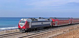
Israel Railways Ltd. is the state-owned principal railway company responsible for all inter-city, commuter, and freight rail transport in Israel. Israel Railways network consists of 1,138 kilometers (707 mi) of track. All its lines are standard gauge. The network is centered in Israel's densely populated coastal plain, from which lines radiate out in many directions. In 2018, Israel Railways carried 68 million passengers.

Highway 20, more commonly known as the Ayalon Highway, or simply Ayalon, is a major intracity freeway in Gush Dan, Israel. The road runs along the eastern border of central Tel Aviv from north to south and connects all of the major highways leading to the city—such as Highway 4 from Ashdod and the Southern regions, Highway 2 from Haifa and the Northern regions, Highway 5 from the East, and Highway 1 from Jerusalem and the Southeast. The Ayalon Highway is heavily used; on an average day, almost 600,000 vehicles enter the freeway. It consists of a multi-lane highway with a multi-track railway located between the opposite travel lanes. Some of the highway's route is along the Ayalon River, hence its name.

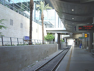
The Tel Aviv Savidor Central railway station is a major railway station on the Ayalon Railway in central Tel Aviv, Israel, serving most lines of Israel Railways.

Beit Shemesh railway station is an Israel Railways station in Beit Shemesh, Israel, on the Tel Aviv–Lod–Jerusalem line. The station is located near the northern industrial zone of Beit Shemesh.
Ben Gurion Airport railway station is an Israel Railways station located in the lower level of Ben Gurion International Airport's Terminal 3. The station opened on 10 October 2004, together with the opening of Terminal 3. The railway line extending to the northwest from the station connects it to Tel Aviv and points north, while in the other direction from the station the railway splits south to Lod and southeast to Modi'in and Jerusalem.
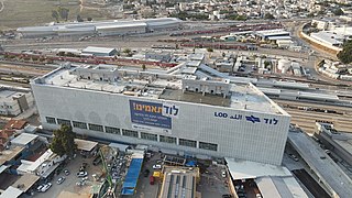
Lod railway station is an Israel Railways station in Lod, Israel, served by most railway lines of Israel Railways. The station is located in the HaRakevet district of south Lod. In December 2006, Lod Station served a daily average of 7,786 passengers.
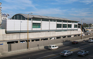
Tel Aviv HaHagana railway station is a major railway station on the Ayalon Railway in southern Tel Aviv, Israel, serving most lines of Israel Railways. It is located in the median of the Ayalon Highway, north of Highway 1 and 400 meters east of the Tel Aviv Central Bus Station. In 2019, over six million passengers used the station, making it the third-busiest in the country after the nearby Savidor Central and HaShalom stations at the time; it was subsequently overtaken by Jerusalem–Yitzhak Navon and demoted to fourth place, but remains the third-busiest station in Tel Aviv.

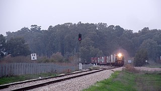
Rail transport in Israel includes heavy rail as well as light rail. Excluding light rail, the network consists of 1,384 kilometers (860 mi) of track, and is undergoing constant expansion. All of the lines are standard gauge and as of 2023 approximately one-fifth of the heavy rail network is electrified, with additional electrification work underway. A government owned rail company, Israel Railways, manages the entire heavy rail network. Most of the network is located on the densely populated coastal plain.
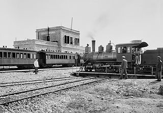
The Jaffa–Jerusalem railway is a railway that connected Jaffa and Jerusalem. The line was built in the Mutasarrifate of Jerusalem by the French company Société du Chemin de Fer Ottoman de Jaffa à Jérusalem et Prolongements and inaugurated in 1892. The project was headed by Joseph Navon, an Ottoman Jewish entrepreneur from Jerusalem, after previous attempts by the British-Jewish philanthropist Sir Moses Montefiore failed. While the first rail track in the Middle East was laid elsewhere, the line is considered to be the first Middle Eastern railway.

Highway 44 is an arterial road in central Israel. It connects Tel Aviv-Yafo and Holon to Ramla, Lod and the Shefela. It is numbered as a north–south road and follows a north-west to south-east path.

Rehovot railway station is an Israel Railways station located in the city of Rehovot. It serves the city, the Weizmann Institute of Science and the nearby science industries park, as well as the city of Ness Ziona. The station is named after Ehud Hadar, CEO of Israel Railways between 1994 and 1996.

The Tel Aviv transportation system is seen as the hub of the Israeli transport network in terms of road, rail, and air transport. The Israeli road network partly centers on Tel Aviv, with some of the country's largest highways passing through or running to the city. The city forms a major part of the country's rail network, whilst Ben Gurion International Airport located near the city is the country's largest airport. There is also a strong public transport system within the city, based primarily on bus transportation.
The Railway to Beersheba is a railroad line that runs from central Israel to the Zin Factories in southern Israel, with a spur to the Be'er Sheva Center Railway Station and branch lines to Ramat Hovav, the Arad phosphate mines and factories in Tzefa, and a connection to the Ashkelon–Beersheba railway. It is part of the main line of Israel Railways, of which the northern starting point of the line designated as the "line to Beersheba" is usually indicated as beginning at Na'an junction, where the railway splits to Beersheba and Jerusalem. Because the line is not limited to Beersheba, it is known in Israel as Mesilat HaDarom.

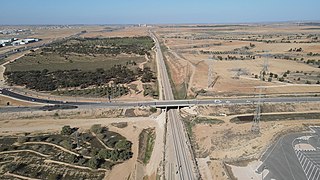
The Tel Aviv–Jerusalem railway is a railway line in Israel connecting the city of Tel Aviv with Jerusalem. The line serves as the main rail link between the two cities, complementing the old Jaffa–Jerusalem railway. As such, the railway is often referred to in Israel as the high-speed railway to Jerusalem to distinguish it from the older, longer and slower line. In spite of that name, the line is not high-speed under the definition used by the International Union of Railways: both its design speed of 200 km/h (125 mph) and its current operational speed of 160 km/h (99 mph) are below the 250 km/h (155 mph) threshold used by the UIC to define high-speed railways, and it is traversed by IR's regular rolling stock instead of the UIC requirement for specially-designed high-speed trains.

Bnei Brak–Ramat HaHayal railway station is a suburban passenger railway station in Israel, operated by Israel Railways. It is located on the Yarkon Railway near the Bnei Brak–Ramat Gan and Bnei Brak–Tel Aviv borders next to the Ayalon Mall and Ramat Gan Stadium. In spite of its proximity to important industrial and commercial areas of Gush Dan as well as to residential areas of Tel Aviv, Bnei Brak is one of the less-popular stations of Israel Railways, possibly because of its misleading name and lack of awareness. As a result, in an effort to increase the public's awareness of the station, the name of the Ramat HaHayal neighborhood located to the north of the station was added to the station's name in 2016.

Herzliya railway station is an Israel Railways passenger station located in the city of Herzliya. The station currently has three island platforms serving two tracks each. In the 2010s, the Ayalon Highway was extended past the station northwards so that the platforms lie contained in the median of the highway, like the train stations in Tel Aviv.
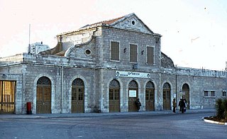
The Jerusalem railway station, also known as the Jerusalem–Khan railway station after the caravanserai building, now the Khan Theater located across the road, to differentiate it from the Jerusalem–Malha and Jerusalem–Yitzhak Navon stations opened after its closure, is a historic railway station in Jerusalem, located between Hebron Road and Bethlehem Road, near the German Colony. It was part of the Jaffa–Jerusalem railway until its closure in 1998.
The Coastal railway line is a mainline railway in Israel, which begins just south of the Lebanon-Israel border on the Mediterranean coast, near the town of Nahariya in Northern Israel and stretches almost the entire Mediterranean coast of the country, to just north of the border with the Gaza Strip in the south.

The Rishon LeZion Moshe Dayan railway station is an Israel Railways station in Rishon LeZion. The station is located adjacent to the Moshe Dayan Interchange on the Ayalon Highway. It serves as the terminus of a new suburban passenger line serving the cities of Holon, Bat Yam, and Rishon LeZion in southern Gush Dan. Current travel time from the station to Tel Aviv HaHagana railway station is about 18 minutes.
The Yarkon Railway is a double-track railroad following the course of the Yarkon River in the central area of Israel. It is about 15 km long, stretching from the Coastal Railway to the Eastern Railway.
