Amravati is the second largest city in the Vidarbha region and ninth largest city in Maharashtra, India. It is administrative headquarters of Amravati district and Amravati division which includes Akola, Buldhana, Washim, and Yavatmal districts. It is one of the Maharashtra's nominated city under Smart Cities Mission.

Datia is the district headquarter of the Datia District in north central Madhya Pradesh,a state of Central India. It is an ancient town, mentioned in the Mahabharata ruled by King Dantavakra. The city is 78 km from Gwalior, 325 km south of New Delhi and 344 km north of Bhopal. About 18 km from Datia is Sonagiri, a sacred Jain hill. Datia is also about 31 km from Jhansi and 52 km from Orchha. The nearest airport is at Gwalior. It was formerly the seat of the eponymous princely state in the British Raj. Datia is situated near Gwalior and on the border with Uttar Pradesh.
Sikar is a city and municipal council in the Sikar district of the state of Rajasthan in India. It is the administrative headquarters of the Sikar district. It is part of the Shekhawati region, which consists of Sikar, Churu and Jhunjhunu. Sikar is a major coaching hub of the country post Kota for competitive examination preparations and has a number of engineering and medical coaching institutes.
Chandwa, is a community development block in Latehar district, in Indian state of Jharkhand. It is located around 75 km from Ranchi, the state capital. As well as its natural environment, it is known for its bauxite and coal mines. It is mineral rich like most of Jharkhand State. It lies at the junction for the NH39 and NH99 roads, and is also an important railway junction.

Kalna or Ambika Kalna is a town in the Purba Bardhaman district of West Bengal, India. It is the headquarters of the Kalna subdivision, situated on the western bank of the Bhāgirathi river. The town is more popularly known as Ambika Kalna, named after the goddess Kali, Maa Ambika. It has numerous historical monuments, such as the Rajbari, and 108 Shiva temples. The city of Kalna is 60 kilometres (37 mi) from Bardhaman.
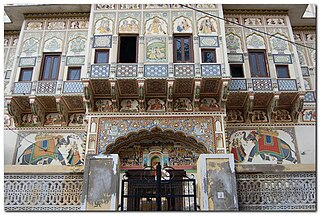
Mandawa is a town, just 29 km from Jhunjhunu city in Jhunjhunu district of Rajasthan, India. It is part of Shekhawati region. Mandawa is located at 28.05°N 75.15°E. It has an average elevation of 316 metres (1036 ft). The nearest railway station is Jhunjhunu railway station.
Puduvayal is a town in Karaikudi taluk, Sivaganga district in the Indian state of Tamil Nadu. It is a town located in the Chettinad region of the Sivagangai district. On road, it is 12 km away from Karaikudi and 21 km away from Aranthangi. This town is famous for its rice mills. Puduvayal is the 2nd largest rice producer in Tamil Nadu. Puduvayal is an important commercial centre for trade in the Sivaganga district and part of the suburban region of Karaikudi. The town is famous for its Veerasekara Umaiyambigai Temple. Nearby Kandanur is famous for Kandanur Sivan Kovil—which is a replica of the Madurai Meenakshi Temple—built by Nagarthars.

Jhunjhunu district is a district of the Indian state of Rajasthan in northern India. The city of Jhunjhunu is the district headquarters.
Gadhinglaj ([ɡəɖᵊɦiŋɡləd͡z]) is a city in India in the Kolhapur district in the southwest corner of the state of Maharashtra, India. It is located on the banks of the river Hiranyakeshi. It is the Taluka (Tehsil) headquarters of Gadhinglaj Taluka and a subdivision headquarters of the Gadhinglaj Subdivision of the Kolhapur District. It is governed by a municipal council. The rapidly growing city is the third largest in the Kolhapur District, with population of more than 50,000. Places to visit like Samagad fort, temples and beautiful weather.
Lalsot is a city with municipality in Dausa district in the Indian state of Rajasthan. Lalsot is the biggest city in dausa district.
Bagar, or Baggar, is a town and municipal council in the Jhunjhunu district of Rajasthan, a northwestern state in India. Known for its heritage havelis, it is located 12 kilometres (7.5 mi) from Jhunjhunu city on NH 8 towards Chirawa-Loharu.
Tain is a village in the Jhunjhunu district, India. It is part of the Shekhawati region of Rajasthan.
Ajeetpura is a town in the Hanumangarh district, Rajasthan state in India.
National Highway 11 or NH 11 is a National Highway in India that links Jaisalmer (Rajasthan) and Rewari (Haryana). This 848 km-long highway passes through Myajlar, Pithala, Jaisalmer, Pokaran, Ramdevara, Phalodi, Bap, Diyatra Gajner, Bikaner, Sri Dungargarh, Rajaldesar, Ratangarh, Rolsabsar, Fatehpur, Tajsar, Mandawa, Jhunjhunu, Bagar, Chirawa, Singhana, Pacheri, Narnaul, Ateli and Rewari.

Mandela is a town in the Shekhawati region and Jhunjhunu district of Rajasthan state in India.
Mandawa Assembly constituency is one of constituencies of Rajasthan Legislative Assembly in the Jhunjhunu.
Kuharu is a village in Mandawa, Jhunjhunu district of Rajasthan in India. It is part of the Shekhawati region. Kuharu is situated 195 km off Jaipur in the north. The town lies between latitude 28°.06’ in the north and longitude 75°.8’ in the east.
Dobra is a small village in Jhunjhunu district of Rajasthan, India. In the 2011 census, there were 1,334 residents. It is about 50 km from Jhunjhunu and 20 km from Pilani. Gotras are Megwal Lamoria and Kaswan. Dadhich Brahman Smaj are also situated here. The nearest primary health center is in Peepli. There is one government middle school and for higher education students go to a nearby city. It is well connected by road and there is plenty of water. There is also a very holy temple of Lord Hanuman named as "Rudana Dham". It has its own celestial pleasure to be felt amidst the greenery.
Bhaisawata Kalan also known by its local as 'Basawata Kalan' is a village in Buhana tehsil in Jhunjhunu district of Rajasthan State, India. It belongs to Jaipur division. It is located 0–45 km towards East from District headquarters Jhunjhunu. 10 km from Buhana. 186 km from State capital Jaipur and 191 km from Delhi..
Kabeersar is a village in Jhunjhunun, Rajasthan, India. Its population as of the 2011 census was 705.