
Perambalur is one of the 38 districts in the state of Tamil Nadu, India. The district headquarters is located at Perambalur. The district occupies an area of 1,752 km² and had a population of 565,223 with a sex-ratio of 1,003 females for every 1,000 males in 2011.

Banke District (Nepali: बाँके जिल्ला[bãke], a part of Lumbini Province, is one of the 77 districts of Nepal. The district, located in midwestern Nepal with Nepalganj as its district headquarters, covers an area of 2,337 km2 and had a population of 385,840 in 2001 and 491,313 in 2011. There are three main cities in the Banke District: Nepalganj, Kohalpur and Khajura Bajaar.

Mandsaur district is a District of Madhya Pradesh state in central India. The town of Mandsaur is the administrative headquarters of the district.The ancient pashupatinath temple is situated in Mandsaur. Large quantities of opium are produced in Mandsaur district.

Ambala district is one of the 22 districts of Haryana state in the country of India with Ambala town serving as the administrative headquarters of the district. District Ambala lies on the North-Eastern edge of Haryana and borders Punjab and Himachal Pradesh. Ambala district is a part of Ambala Division.

Amroha district is one of the 75 districts of Uttar Pradesh state in northern India. Amroha town is the district headquarters. According to the Government of India, the district is one of the Minority Concentrated Districts on the basis of the 2001 census data on population, socio-economic indicators and basic amenities indicators.

Barpeta is a town in Barpeta district of the state of Assam in India and is district headquarters. The city is located 90 kilometres (56 mi) north west of Guwahati and is one of the major cities in Western Assam. It is also called Satra Nagari of Assam due to the presence of various Vaishnavite Satras in the vicinity.
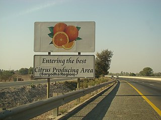
Sargodha District, is a district of Punjab, Pakistan. The capital of the district is Sargodha. It is an agricultural district, wheat, rice, and sugarcane along with Kinno being its main crops. The Sargodha district and region is also famous for citrus fruit including Kinnow, orange and lemon. The district has an area of 5,864 km2.

Balotra is a city in Barmer district of Rajasthan state in India. It is about 100 kilometres (62 mi) from Barmer city.
Chhata is a town and a nagar panchayat in Mathura district in the state of Uttar Pradesh, India. Earlier this town was known as Chhatravan.
Jamadoba is a neighbourhood in Dhanbad in Dhanbad Sadar subdivision in Dhanbad district in Jharkhand state, India.
Kirtinagar is a town and a Nagar Panchayat and a Taluk in Tehri Garhwal district in the Indian state of Uttarakhand.
Kustai is a neighbourhood in Dhanbad in Dhanbad Sadar subdivision of Dhanbad district in Jharkhand state, India.
Tisra is a neighbourhood in Dhanbad in Dhanbad Sadar subdivision of Dhanbad district in Jharkhand state, India.

Gujarati Pashtuns/Pathans are a group of Pashtuns who are settled in the region of Gujarat in western India. They now form a distinct community of Gujarati and Urdu/Hindi speaking Muslims. They are distributed throughout the state, but live mainly in Ahmedabad, Rajkot, Junagadh, Surat, Bhavnagar, Panchamahal, Koth, Kotha, Borsad, Kheda, Banaskantha, Bharuch, Gandhinagar, Sabarkantha, Vadodara and Mehsana. They mainly speak Urdu/Hindi with many Pashto loanwords, but most of them have been Indianized so some may have Gujarati as their first language as well, few elders in the community still speak Pashto. Common tribes include Babi or Babai, Niazi, Khan, Bangash, Durrani, and Yousafzai.
Baunsalundi is a small village in Gram Panchayat Baunsalundi located near Bhanjanagar of Ganjam district in Odisha. It is located 91 km towards North from District Headquarters Chhatrapur. 162 km from State capital Bhubaneswar.. Odia is the Language here.
Garalbari is a gram panchayat area located in the Jalpaiguri district of West-Bengal, India. Geographically, Garalbari is located in the latitude of 26.448391N and longitude of 88.6434308E. Garalbari is a panchayat village in Jalpaiguri Block of Jalpaiguri District of West Bengal State, India. It is located 13 km away towards the South from the district headquarters Jalpaiguri and 12 km away from Jalpaiguri city. The postal index number of Garalbari is 735132.
Bhagautipur is a village in Salarpur block, Budaun district, Uttar Pradesh, India. Its village code is 128327. Budaun railway station is 5 KM away from the village. The village is administrated by Gram Panchayat. The major caste of residing people in the village is Kurmi.
Kupri is a village and gram panchayat in Jagat block, Budaun district, Uttar Pradesh, India. Its village code is 128441. The village is located 16 KM East from Budaun railway station. According to 2011 Census of India, the total population of the village is 1210, out of 675 are males and 535 are females.
Panewadi is village in Nandgaon Taluka near manmad, belongs to Khandesh and Northern Maharashtra region in Nashik district. It is located 95 KM towards East from District head quarters Nashik, 260 KM from State capital Mumbai. Khadgaon (6 ), Mohegaon (6 ), Karhi (6 ), Kundalgaon (9 ), Laxminagar (9 )) are the nearby Villages to Panewadi. Panewadi is surrounded by Yeola Taluka to the south, Chandwad Taluka to the west, Malegaon Taluka to the north, and Deola Taluka to the west. It is one of the 100 villages of Nandgaon Block of Nashik district. The village is home to 2842 people, among them 1472 (52%) are male and 1370 (48%) are female. 78% of the whole population are from general caste, 10% are from schedule caste and 12% are schedule tribes. Child population of Panewadi village is 16%, among them 54% are boys and 46% are girls. According to the administration register, the village code of Panewadi is 550317. The village has 498 houses.
Makhan Nagar, is a town and a Nagar Panchayat in Narmadapuram district in the state of Madhya Pradesh, India. It is the birthplace of the noted Hindi poet Makhanlal Chaturvedi. It is also famous for its shrine of Lord Hanuman, whose idol is said to have come from a Baodi stepwell beside the shrine.