Interstate 45 (I-45) is an interstate highway located entirely within the U.S. state of Texas. While most interstate routes ending in five are cross-country north-south routes, I-45 is comparatively short, with the entire route located in Texas. It connects the cities of Dallas and Houston, continuing southeast from Houston to Galveston over the Galveston Causeway to the Gulf of Mexico.

U.S. Route 290 is an east–west U.S. Highway located entirely within the state of Texas. Its current western terminus is at Interstate 10 near Harper, and its eastern terminus is at Interstate 610 on the northwest side of Houston. It is the main highway between Houston and Austin and is a cutoff for travelers wanting to bypass San Antonio on Interstate 10.
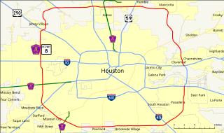
Interstate 610 (I-610) is a freeway that forms a 38-mile-long (61 km) loop around the inner city sector of city of Houston, Texas. Interstate 610, colloquially known as The Loop, Loop 610, The Inner Loop, or just 610, traditionally marks the border between the inner city of Houston and its surrounding areas. It is the inner of the three Houston beltways, the other two being Beltway 8 and State Highway 99, of which various segments are under construction or planning. It is one of four interstate loops not to share its route with another interstate freeway, the others being I-270 in Ohio, I-295 in Florida, and I-485 in North Carolina.

The Hardy Toll Road is a toll road in the Greater Houston area of the U.S. state of Texas, maintained by the Harris County Toll Road Authority. The route runs from Interstate 610 near central Houston to Interstate 45 just south of the Harris–Montgomery county line. The road generally parallels Interstate 45. The portion from I-610 to Crosstimbers Road was designated on September 26, 1984 as Spur 548, although this is unsigned.
Beltway 8 (BW8), the Sam Houston Parkway, along with the Sam Houston Tollway, is an 88-mile (142 km) beltway around the city of Houston, Texas, United States, lying entirely within Harris County.
Texas state highways are a network of highways owned and maintained by the U.S. state of Texas. The Texas Department of Transportation (TxDOT) is the state agency responsible for the day-to-day operations and maintenance of the system. Texas has the largest state highway system, followed closely by North Carolina's state highway system. In addition to the nationally numbered Interstate Highways and U.S. Highways, the highway system consists of a main network of state highways, loops, spurs, and beltways that provide local access to the other highways. The system also includes a large network of farm to market roads that connect rural areas of the state with urban areas and the rest of the state highway system. The state also owns and maintains some park and recreational roads located near and within state and national parks, as well as recreational areas. All state highways, regardless of classification, are paved roads. The Old San Antonio Road, also known as the El Camino Real, is the oldest highway in the United States, first being blazed in 1691. The length of the highways varies from US 83's 893.4 miles (1,437.8 km) inside the state borders to Spur 200 at just 0.05 miles long.

State Highway 19 is a state highway in Texas runs from Huntsville to Paris in east Texas.
Loop 286 is a loop highway around Paris, Texas. Parts of it are co-signed as U.S. Highway 82 and U.S. Highway 271. Loop 286 is mostly a divided highway with partially controlled access, but parts of it on the south side of town near State Highway 19 are still 2 lanes.

Loop 9 is a proposed state highway that will be located on the southern fringes of the Dallas/Fort Worth Metroplex along the southern Dallas County line westward into northern Johnson County. It will measure about 45 miles (72 km) in length. Although it can be considered the southern counterpart to the President George Bush Turnpike (PGBT), it is actually being re-integrated into a plan for a broad outer loop that would extend far north of the metroplex. Loop 9 and the outer loop are part of a long-term plan to serve the growing, expanding DFW population, forecast to rise past 10 million by 2040.

State Highway 45 is a highway loop around Austin, Texas, that exists in two open segments. The official designation of SH 45 is such to form a complete loop around Austin, a distance of roughly 80 miles (130 km).

U.S. Highway 90 Alternate is an alternate route to U.S. Highway 90 in the U.S. state of Texas, running from west of Seguin east via Seguin, Gonzales, Hallettsville, Eagle Lake, Rosenberg and Sugar Land to northeastern Houston. South of Downtown Houston, US 90 Alternate is built to freeway and near-freeway standards along a section of South Main Street.
Interstate 10 (I-10) is the major east–west Interstate Highway in the Southern United States. In the U.S. state of Texas, it runs east from Anthony, at the border with New Mexico, through El Paso, San Antonio and Houston to the border with Louisiana in Orange, Texas. At just under 880 miles (1,420 km), the Texas segment of I-10, maintained by the Texas Department of Transportation, is the longest continuous untolled freeway in North America that is operated by a single authority,. It is also the longest stretch of highway with a single designation within a single state. Mile marker 880 and its corresponding exit number in Orange, Texas, are the highest numbered mile marker and exit on any freeway in North America. After widening was completed in 2008, a portion of the highway west of Houston is now also believed to be the widest in the world, at 26 lanes. There is a wider section in China on the G4 Beijing–Hong Kong–Macau Expressway; however, that section is a toll plaza approach.
Farm to Market Road 1765 or FM 1765 is a 7.969-mile (12.825 km) farm to market road in the U.S. state of Texas. It begins at FM 2004 in La Marque and heads east to Loop 197 in Texas City. The portion of the route from SH 3 to Loop 197 was designated as SH 348 from June 10, 1943 until the two routes were combined on November 29, 1990.
Farm to Market Road 865 (FM 865) is a state highway within the Houston–Sugar Land–Baytown metropolitan area in the U.S. state of Texas. Locally, the road is known as Cullen Boulevard.

U.S. Highway 75 (US 75) in the state of Texas is a U.S. Highway that begins in Dallas and heads north to the Oklahoma state line.
Loop 289 is a multi-lane beltway servicing Lubbock as a freeway. The highway serves as the southern end for Interstate 27 on the south side of the city. The highway passes about a mile south of Lubbock Preston Smith International Airport on the north side near the intersection with I-27.
Texas State Highway Spur 261 is a Texas State Spur in Harris County, Texas. It runs from North Loop Freeway Interstate 610, until it reaches Interstate 45.


