This article's lead section does not adequately summarize key points of its contents. (August 2018) |
This article relies largely or entirely on a single source . (August 2018) |
State Highway Loop 340 | ||||
---|---|---|---|---|
Route information | ||||
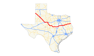
Length | 5.266 mi [1] (8.475 km) | |||
Existed | 1986 – present | |||
Major junctions | ||||
South end | ||||
North end | ||||
Highway system | ||||
|
Texas State Highway Loop 340 circles the city of Waco in McLennan County, Texas.
Waco is a city in central Texas and is the county seat of McLennan County, Texas, United States. It is situated along the Brazos River and I-35, halfway between Dallas and Austin. The city had a 2010 population of 124,805, making it the 22nd-most populous city in the state. The 2017 US Census population estimate is 136,436 The Waco Metropolitan Statistical Area consists of McLennan and Falls Counties, which had a 2010 population of 234,906. Falls County was added to the Waco MSA in 2013. The 2017 US Census population estimate for the Waco MSA is 268,696.
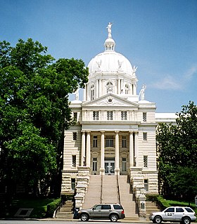
McLennan County is a county located on the Edwards Plateau in Central Texas. As of the 2010 census, its population was 234,906. Its county seat is Waco. The U.S. census 2017 county population estimate is 251,259. The county is named for Neil McLennan, an early settler.
Loop 340 was designated on September 27, 1960, running from US 84 southeastward and eastward to US 77 south of Waco. On February 26, 1964, Loop 340 extended north to SH 6 and Loop 232, and Loop 232 from SH 6 to US 84 and FM 2418 was cancelled and combined with Loop 340. On February 29, 1968, it extended southwest to FM 3051. On September 25, 1984, SH 6 was rerouted concurrent with Loop 340. The old route of SH 6 became Loop 484.
Texas State Highway Loop 484 is a 2.5 mile stretch of highway located in eastern Waco, Texas. The highway connects US Bus. 77-N and Texas State Highway 6.
The entire route is in McLennan County.
Location | mi | km | Destinations | Notes | |
---|---|---|---|---|---|
Waco | Southern terminus; continues as SH 6, access to Providence Medical Center | ||||
Imperial Drive | Northbound exit and southbound entrance | ||||
Beverly Drive | Southbound exit and northbound entrance | ||||
Bagby Avenue | Northbound exit and southbound entrance | ||||
Northbound exit and southbound entrance | |||||
North end of freeway, access to Hillcrest Baptist Medical Center | |||||
Robinson | Interchange | ||||
12th Street Road | South end of freeway | ||||
Waco | |||||
Brazos River turnaround | North end of freeway; northbound exit and southbound entrance | ||||
North end of SH 6 overlap | |||||
Bellmead | Interchange | ||||
Interchange | |||||
Waco | Northern terminus Split intersection | ||||
1.000 mi = 1.609 km; 1.000 km = 0.621 mi |
State Highway 121 is a state highway angling from southwest to northeast through north central Texas. It runs from downtown Fort Worth, Texas at the junction of Interstate 35W to Bonham, Texas, just north of a junction with U.S. Highway 82.
State Highway 6 runs from the Red River, the Texas–Oklahoma boundary, to northwest of Galveston, where it is known as the Old Galveston Highway. In Sugar Land and Missouri City, it is known as Alvin-Sugarland Road and runs perpendicular to I-69/US 59. In the Houston area, it runs north to FM 1960, then northwest along US Highway 290 to Hempstead, and south to Westheimer Road and Addicks, and is known as Addicks Satsuma Road. In the Bryan–College Station area, it is known as the Earl Rudder Freeway. In Hearne, it is known as Market Street. In Calvert, it is known as Main Street. For most of its length, SH 6 is not a limited-access road.
State Highway 7 is an east–west state highway that runs from Interstate 35 south of Waco to U.S. Highway 84 about 3 miles (5 km) west of the Texas-Louisiana state line. Between Crockett and Nacogdoches, SH 7 passes through the Davy Crockett National Forest.
State Highway 46, or SH 46, is a 71.4-mile (114.9 km) state highway in the U.S. state of Texas that runs from State Highway 16 east of Bandera to the intersection of SH 123 and SH 123 Business just south of Seguin.
State Highway 81 is a Texas state highway that runs from Hillsboro to Grandview. It was designated in 1991 to replace U.S. Highway 81, which was decommissioned south of Fort Worth.
U.S. Route 84 is a U.S. highway that runs from Pagosa Springs, CO to Midway, GA. In Texas, the highway enters the state from New Mexico at Farwell, near the Panhandle region. Major cities along the highway include Lubbock, Abilene, Waco and Palestine. The highway exits Texas into Louisiana near Joaquin, crossing the Toledo Bend Reservoir.
U.S. Route 77 Business is a business loop of US 77 in Waco. The highway is the old alignment of US 77 through the city and was formerly signed as a US 77 & US 81 Business Route, but designated as Loop 491 on October 2, 1970 until it was changed to the current Business US 77 designation on June 21, 1990. The section of highway from Loop 484 to US 84 is a freeway, making it the only business route in Texas that is a freeway.
This Texas road-related article is a stub. You can help Wikipedia by expanding it. |