
Gorakhpur is a city along the banks of the Rapti river in the Purvanchal region of the Indian state of Uttar Pradesh. It is situated 270 kilometres north-east of the state capital Lucknow. It is the administrative headquarters of Gorakhpur district, North Eastern Railway Zone and Gorakhpur division. The city is home to the Gorakhnath Math, a Gorakhnath temple. The city also has an Indian Air Force station, since 1963. Gita Press, the world's largest publisher of Hindu religious texts is also located in Gorakhpur.

Gopalganj is one of the administrative districts in the Indian state of Bihar. The district headquarters is the town of Gopalganj, and the district is part of Saran Division. Major languages spoken are Bhojpuri, Hindi, and Urdu.

Deoria district, one of the districts of eastern Uttar Pradesh, India has its headquarters located at Deoria and is a part of Gorakhpur division. It came into existence on 16 March 1946 from Gorakhpur district.

Siwan is a city and nagar parishad in the Indian state of Bihar. It is the administrative headquarters of Siwan district and one of the urban settlements out of three in the district. It is located close to Uttar Pradesh.
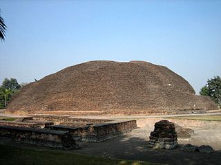
Kushinagar is a district of the state of Uttar Pradesh in India situated in the easternmost part of the state. It has the administrative headquarters at Ravindra Nagar Dhoos. The district is named such after the town Kushinagar, a Buddhist pilgrimage site where Gautama Buddha attained parinirvana in the 5th century BCE. Since the independence of India, Kushinagar district was a part of Deoria District and came into existence on 13 May 1994 as a separate district division. It was earlier known as Padrauna and thereafter was renamed Kushinagar on 19 June 1997.The Biggest Town in Kushinagar District is Padrauna.
Padrauna is a city and district headquarter of Kushinagar in the Indian state of Uttar Pradesh. Its ancient name was Pava where Buddha took his last meal. It is the place where Rama spent a few days of his life. After passing from Padrauna, Rama reached at Ramkola where he made a hut with his wife Sita and younger brother Lakshman to stay. Padrauna is also the place of ancient Malla Kshatriyas who were following a democratic form of government from their Santhagara.It is situated 21 kilometers east of Kushinagar town.
Ahirauli Baghel is an Indian village located on the border of Bihar and Uttar Pradesh. Ahirauli Baghel comes under Bankata Block of Deoria District, Uttar Pradesh. It belongs to Gorakhpur Division. It is located 47 KM towards East from District head quarters Deoria. It distance is 374 KM from State capital Lucknow. Bhojpuri and Hindi is the primary language spoken in this village.

Gidhaur is a small town in the Jamui District of Bihar. In the early-modern period, it was the centre of the Gidhaur chieftaincy.
National Highway 28 is a National Highway in India that links Lucknow in Uttar Pradesh to Barauni in Bihar. It crosses into Bihar about 20 km (12 mi) from Kushinagar. It joins National Highway 31 at Barauni north of the river Ganges. The total length of NH 28 is 570 km (350 mi). It traverses 259 km (161 mi) in Bihar and 311 km (193 mi) in Uttar Pradesh.

Semra is a village in Gopalganj district of Bihar state, India. Semra is located just West and North corner of Thawe. Semra is famous for two religious institutions, namely Semra Madarsa Ehsania, affiliated with Nadwa, Lucknow, and Semra Yateem Khana. There is also a famous Ramjanki mandir, and a middle school. Semra is famous for Arhar Daal.

The Barauni–Gorakhpur, Raxaul and Jainagar lines are a set of three lines connecting Barauni in the Indian state of Bihar with Gorakhpur in Uttar Pradesh. The lines run in an east–west direction between the Ganges and India-Nepal border, covering northern Bihar west of the Kosi river and eastern Uttar Pradesh. The southernmost of the lines connects via Hajipur Junction, Sonpur Junction and Chhapra. The central line connects via Muzaffarpur, Motihari and Sugauli. The northern line connects via Darbhanga, Sitamarhi and Raxaul. The lines have interconnections between them and the northern line has extensions to places near the India–Nepal border.

Gorakhpur Junction railway station is located in the city of Gorakhpur in the Indian state of Uttar Pradesh. It has the world's second longest railway platform. It serves as the headquarters of the North Eastern Railway. The station offers Class A-1 railway station facilities.
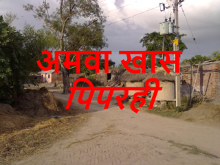
Piparahi is one of the habitation/locality (Tola) of Amwa Khas village in Kushinagar district of Uttar Pradesh. It comes under Dudahi block of Tamkuhi Raj tehsil in the district. Gobaraha in north, Dasahwaha in south, Ultahawa in west and Lilahat in east are nearby habitation. This Tola is about 5 kilometers away from The Gandaki River in east. It is about 3 kilometers near U.P-Bihar border in north. The village is 10 kilometers away from Dudahi railway station, 35 kilometers away from Tamkuhi Raj tehsil on Grand Trunk highway and 38 kilometers from Padrauna – district secretariat. It is highly populated habitation. Piparahi has one government primary school and one private primary school- Shri Mahatma Gandhi Gyan Mandir. This locality has two temples and a market, Piparahi Bazar.) People of Hindu and Muslim community resides here peacefully. Most of the population of the habitation is from backward class. It is covered under Pradhan mantri gram sadak yojna and Rajive Gandhi vidyut vikash yojna. Land of the villagers are highly fertile for sugarcane, wheat, rice and other seasonal crops.
The Muzaffarpur–Gorakhpur line is a set of three lines connecting Muzaffarpur in the Indian state of Bihar with Gorakhpur in Uttar Pradesh. The lines run in an east–west direction between the Gandak and India–Nepal border, covering North Bihar west of the Kosi river and eastern Uttar Pradesh. The southernmost of the three lines connects via Hajipur Junction, Sonpur Junction and Chhapra. The central line connects via Motihari and Sugauli. The northern line connects via Sitamarhi and Raxaul. The lines have interconnections between them and the northern line has extensions to places near the India–Nepal border.
Madhopur is a village in Barharia block of Siwan district in the Indian state of Bihar. It is located 2 kilometers (1.24 mi) north of the Barharia block at Barharia-Gopalganj road, It is located 18 kilometres (11 mi) east of the district headquarters Siwan and 150 kilometres (93 mi) from the state capital Patna. Madhopur is surrounded by Sahpur to the north, Barasra south, Chhatisi east, and Rasulpur to the west. Barharia, Siwan, Gopalganj, Mirganj, Barauli and Thawe are nearby towns.

Banjari is a large village in Gopalganj District of Bihar, India. It is located 1.3 km towards North-West from the district headquarters Gopalganj. Banjari village code is 1495000. It comes under the administration of Basdila Khas Gram panchayat.

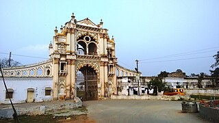
Thawe Mandir, the Temple of Maa Thawewali is situated in Thawe, in Gopalganj District in the State of Bihar, India. It is only 6 km from Gopalganj town on the Gopalganj-Siwan National Highway.

Siwan Junction railway station is a railway station in the city of Siwan, in the state of Bihar.This station is well connected to all major cities of India serving passengers of District Siwan and Gopalganj . It is well connected with major cities like Kolkata, Amritsar, Ranchi, Guwahati, Lucknow, Delhi, Kanpur, Jamshedpur and Gorakhpur.

The Lucknow–Gorakhpur line is a railway route in Uttar Pradesh. It is classified as 'B special class' according to Indian Railways standards, and its trains can reach up to 123 kilometres per hour (76 mph) on this line. The line is doubled broad gauge and electrified, and it is the first fully electrified railway line of the North Eastern Railway zone.
The Tatanagar–Thawe Express is an Express train belonging to South Eastern Railway zone that runs between Tatanagar Junction and Thawe Junction in India. It is currently being operated with 18181/18182 train numbers on a daily basis.
