
The River Aire is a major river in Yorkshire, England, 92 miles (148 km) in length. Part of the river below Leeds is canalised, and is known as the Aire and Calder Navigation.

Guiseley is a town in metropolitan borough of the City of Leeds, West Yorkshire, England. Historically part of the West Riding of Yorkshire, it is situated south of Otley and Menston and is now a north-western suburb of Leeds.
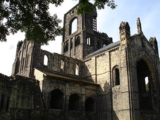
Kirkstall is a north-western suburb of Leeds, West Yorkshire, England, on the eastern side of the River Aire. The area sits in the Kirkstall ward of Leeds City Council and Leeds Central and Headingley parliamentary constituency, represented by Alex Sobel. The population of the ward at the 2011 Census was 21,709.

Airedale is a valley, or dale, in North Yorkshire and West Yorkshire, England. It is named after the River Aire, which flows through it. The upper valley, from Malham Cove to Airton, is known as Malhamdale, named after the village of Malham. At Airton the valley widens and becomes Airedale proper. The river flows past Skipton on to Keighley, Bingley, Shipley, and Leeds.
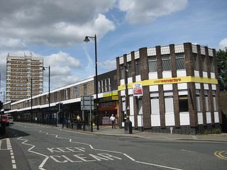
Armley is a district in the west of Leeds, West Yorkshire, England. It starts less than 1 mile (1.6 km) from Leeds city centre. Like much of Leeds, Armley grew in the Industrial Revolution and had several mills, one of which now houses the Leeds Industrial Museum at Armley Mills. Armley is predominantly and historically a largely working class area of the city, still retains many smaller industrial businesses, and has many rows of back-to-back terraced houses.
Harehills is an inner-city area of east Leeds, West Yorkshire, England. It is about 1 mile (1.6 km) northeast of Leeds city centre. Harehills is between the A58 and the A64. It sits in the Gipton & Harehills ward of Leeds City Council and the Leeds East parliamentary constituency, between Burmantofts and Gipton, and adjacent to Chapeltown.

Hunslet is an inner-city suburb in south Leeds, West Yorkshire, England. It is 1 mile (1.6 km) southeast of the city centre and has an industrial past.

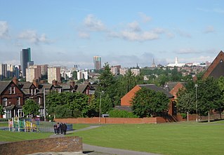
Beeston is a suburb of Leeds, West Yorkshire, England located on a hill about 2 miles (3 km) south of the city centre.

Woodhouse is a largely residential area just north of the city centre of Leeds and close to the University of Leeds. The area considered as Woodhouse is partly in the Little London and Woodhouse ward and partly in the Headingley & Hyde Park ward of City of Leeds metropolitan district.

Allerton Bywater is a semi-rural village and civil parish in the south-east of the City of Leeds metropolitan borough in West Yorkshire, England. The population of the civil parish at the 2011 census was 4,717. The village itself is 2 miles (3.2 km) north of Castleford, with neighbouring villages Kippax and Great Preston all providing local amenities. St Aidan's Nature reserve borders the village attracting many visitors with its beauty and charm. Additionally "The Lines Way" bridle path which runs from Garforth through to Allerton following the old train track provides a pleasant route for walkers, joggers and cyclists alike. The River Aire flows through the village to the south-west.

Quarry Hill is an area of central Leeds, West Yorkshire, England. It is bounded by the Leeds Inner Ring Road in the east and north and the Leeds – York / Hull railway in the south. The area falls within the City and Hunslet ward of Leeds City Council.

Holbeck is an inner city area of Leeds, West Yorkshire, England. It begins on the southern edge of Leeds city centre and mainly lies in the LS11 postcode district. The M1 and M621 motorways used to end/begin in Holbeck. Now the M621 is the only motorway that passes through the area since the end of the M1 moved to Hook Moor near Aberford. Since large parts of Holbeck have been vacated in preparation for the regeneration of the area, the district has in large parts suffered from a population exodus. Holbeck had a population of 5,505 in 2011. The district currently falls within the Beeston and Holbeck ward of Leeds City Council.
Cottingley is a suburban village within the City of Bradford district in West Yorkshire, England between Shipley and Bingley. It is known for the Cottingley Fairies, which appeared in a series of photographs taken there during the early 20th century.
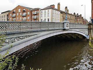
Leeds Bridge is a historic river crossing in Leeds, England. The present cast iron road bridge over the River Aire dates from 1870. It is Grade II listed.

Kirk Smeaton is a village and civil parish in North Yorkshire, England. It is located at the southern end of the county, close to South Yorkshire and East Riding of Yorkshire. Historically, the village was part of the West Riding of Yorkshire until 1974.

The architecture of Leeds, a city and metropolitan borough in West Yorkshire, England, encompasses a wide range of architectural styles and notable buildings. As with most northern industrial centres, much of Leeds' prominent architecture is of the Victorian era. However, the City of Leeds also contains buildings from as early as the Middle Ages such as Kirkstall Abbey, one of Britain's best preserved ruined Cistercian monasteries, as well as examples of 20th century industrial architecture, particularly in the districts of Hunslet and Holbeck.
Tetley's Brewery(Joshua Tetley & Son Ltd) was an English regional brewery founded in 1822 by Joshua Tetley in Hunslet, now a suburb of Leeds, West Yorkshire. The beer was originally produced at the Leeds Brewery, which was later renamed the Leeds Tetley Brewery to avoid confusion with a microbrewery of the same name.

Chapel Allerton is an inner suburb of north-east Leeds, West Yorkshire, England, 2 miles (3.2 km) from the city centre.
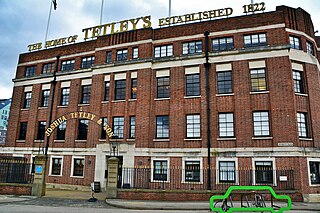
Aire Park is a planned 24 acres (9.7 ha) mixed-use development in Hunslet, south of the city centre of Leeds, West Yorkshire, England. It is being developed by the international real estate organisation Vastint, and will mostly occupy the abandoned brownfield site of the former Tetley's Brewery. It is named after the River Aire, which flows nearby.

Newlay is a suburb of Horsforth, in West Yorkshire, England. Originally a hamlet, it is now part of Horsforth parish in the City of Leeds District, and has its own conservation area. Newlay is situated on the Leeds and Liverpool Canal and the River Aire, some 5 miles (8 km) north west of Leeds city centre.


