
Plumas County is a county in the Sierra Nevada of the U.S. state of California. As of the 2020 census, the population was 19,790. The county seat is Quincy, and the only incorporated city is Portola. The largest community in the county is East Quincy. The county was named for the Spanish Río de las Plumas, which flows through it. The county itself is also the namesake of a native moth species, Hadena plumasata.

A National Scenic Byway is a road recognized by the United States Department of Transportation for one or more of six "intrinsic qualities": archeological, cultural, historic, natural, recreational, and scenic. The program was established by Congress in 1991 to preserve and protect the nation's scenic but often less-traveled roads and promote tourism and economic development. The National Scenic Byways Program (NSBP) is administered by the Federal Highway Administration (FHWA).

Logan Canyon is a canyon in the western United States in northeastern Utah, which cuts its way through the Bear River Mountains, a branch of the Wasatch Range. It is popular for both summer and winter activities, especially rock-climbing, hiking, camping, fishing, snowmobiling, and skiing, at the Beaver Mountain ski resort. The canyon rises to an elevation of approximately 7,800 feet (2,400 m) above sea level, after a vertical climb of about 2,900 feet (880 m). Just beyond the summit is a steep road leading into Bear Lake Valley and scenic overlooks that provide views of deep blue Bear Lake. The western terminus is at Logan in Cache County and the eastern terminus is at Garden City in Rich County.
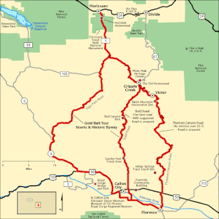
The Gold Belt Tour Scenic and Historic Byway is a National Scenic Byway, a Back Country Byway, and a Colorado Scenic and Historic Byway located in Fremont and Teller counties, Colorado, USA. The byway is named for the Gold Belt mining region. The Cripple Creek Historic District is a National Historic Landmark. The byway forms a three-legged loop with the Phantom Canyon Road, the Shelf Road, and the High Park Road (paved).
The Catalina Highway, officially the General Hitchcock Highway, is the popular name for a Forest Highway and scenic route located in Pima County in southern Arizona. Also known as the Sky Island Scenic Byway, the Mount Lemmon Highway and Arizona Forest Highway 39, the Catalina Highway is the only paved roadway providing access to the resort village of Summerhaven as well as various recreational and scientific facilities located near the summit of Mount Lemmon. Ascending from the desert floor in Tucson to near the summit of Mount Lemmon, the short highway gains over 6,000 ft (1,800 m), showcasing a variety of climates ranging from lowland desert to alpine forests. The name sky island comes from the analogy of these mountains being like islands of forest in a sea of desert. It is designated as a scenic byway by the National Scenic Byways Program. and an Arizona Scenic Road by the Federal Highway Administration.

Big Cottonwood Canyon is a canyon in the Wasatch Range 12 miles (19 km) southeast of Salt Lake City in the U.S. state of Utah. The 15-mile (24 km)-long canyon provides hiking, biking, picnicking, rock-climbing, camping, and fishing in the summer. Its two ski resorts, Brighton and Solitude, are popular among skiers and snowboarders. The canyon is accessed by The Big Cottonwood Canyon Scenic Byway (SR-190), which runs its length to Guardsman Pass at the top of the canyon, allowing travel to Park City in the summer months.
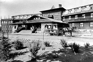
The El Tovar Hotel, also known simply as El Tovar, is a former Harvey House hotel situated directly on the south rim of the Grand Canyon in Arizona, United States.

The Lariat Loop National Scenic and Historic Byway is a National Scenic Byway and a Colorado Scenic and Historic Byway located in Jefferson County, Colorado, USA. The byway is a 40-mile (64 km) loop in the Front Range foothills west of Denver through Golden, Lookout Mountain Park, Genesee Park, Evergreen, Morrison, Red Rocks Park, and Dinosaur Ridge. The Lariat Loop connects to the Mount Evans Scenic Byway at Bergen Park.
Harris Wash is a long tributary of the Escalante River located in Garfield County in southern Utah, in the western United States. Over 40 miles (64 km) long with a drainage of 270 square miles (700 km2), it exhibits many of the geologic features found in the Canyons of the Escalante, including high vertical canyon walls and narrow slot canyons. A popular recreational destination and a historic transportation route, it is located within the Grand Staircase–Escalante National Monument.
The Dinosaur Diamond is a 486-mile (782 km) scenic and historic byway loop through the dinosaur fossil laden Uinta Basin of the U.S. states of Utah and Colorado. The byway comprises the following two National Scenic Byways:

Grand Canyon: The Hidden Secrets is a 34-minute short IMAX documentary film that was theatrically released on June 16, 1984. The film was created, directed, and written by American filmmaker Kieth Merrill and was produced by Destination Cinema. The music is composed by Bill Conti.
The Trail of the Ancients is a collection of National Scenic Byways located in the U.S. Four Corners states of Utah, Colorado, New Mexico, and Arizona. These byways comprise:

The Woodlands Trace National Scenic Byway, also known as "The Trace," is the major north–south roadway that traverses the Land Between the Lakes National Recreation Area in two counties in western Kentucky and northwestern Stewart County in northwest Middle Tennessee. It is estimated to be 43.1 miles (69.4 km) in length. The road is part of the National Scenic Byway system. Although it is not signed, it is listed on LBL's road logs as FD-100.
The Peak to Peak Scenic Byway is a 55-mile (89 km) National Forest Scenic Byway and Colorado Scenic and Historic Byway located in Gilpin, Boulder, Larimer counties, Colorado, USA. The Peak to Peak Highway was originally built in 1918 and provides views of the Front Range mountains in the Colorado Rocky Mountains. It was Colorado's first scenic highway. The Central City/Black Hawk Historic District is a National Historic Landmark.
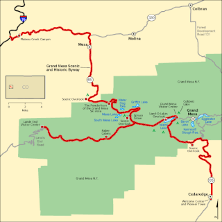
The Grand Mesa National Scenic Byway is a 63-mile (101 km) National Scenic Byway, National Forest Scenic Byway, and Colorado Scenic and Historic Byway located in Delta and Mesa counties, Colorado, USA. The byway traverses Grand Mesa, the most extensive flat-topped mountain on Earth, and reaches an elevation of 10,849 feet (3,307 m). The byway comprises Colorado State Highway 65 from Cedaredge to Interstate 70 Exit 49 and Forest Service Road 100 to the Land's End Observatory.
The Colorado River Headwaters National Scenic Byway is an 80-mile (129 km) National Scenic Byway and Colorado Scenic and Historic Byway located in Eagle and Grand counties, Colorado, US. The byway follows the upper Colorado River from Grand Lake down to State Bridge. The byway connects with the Trail Ridge Road/Beaver Meadow National Scenic Byway at Grand Lake.
The Unaweep Tabeguache Scenic Byway is a 133-mile (214 km) Colorado Scenic and Historic Byway located in Mesa, Montrose, and San Miguel counties, Colorado, USA. The byway explores the Colorado Plateau canyon country of far western Colorado.

The West Elk Loop Scenic and Historic Byway is a 205-mile (330 km) National Forest Scenic Byway and Colorado Scenic and Historic Byway located in Delta, Garfield, Gunnison, Montrose, and Pitkin counties Colorado, USA. The byway reaches its zenith at Kebler Pass, elevation 10,007 feet (3,050 m), between Crested Butte and Paonia.
