The Hatch is a rural [2] suburb of Port Macquarie, a city in New South Wales.
The Hatch is home to The Hatch Farm, a 150-acre working farm with accommodation, located on the bank of the Maria River, a watercourse of the Hastings River catchment. [3]
The Hatch is a rural [2] suburb of Port Macquarie, a city in New South Wales.
The Hatch is home to The Hatch Farm, a 150-acre working farm with accommodation, located on the bank of the Maria River, a watercourse of the Hastings River catchment. [3]

John Joseph William Molesworth Oxley was an explorer and surveyor of Australia in the early period of British colonisation. He served as Surveyor General of New South Wales and is perhaps best known for his two expeditions into the interior of New South Wales and his exploration of the Tweed River and the Brisbane River in what is now the state of Queensland.

Port Macquarie, locally nicknamed Port, is a coastal city the local government area of Port Macquarie-Hastings. It is located on the Mid North Coast of New South Wales, Australia, about 390 km (242 mi) north of Sydney, and 570 km (354 mi) south of Brisbane. The city is located on the Tasman Sea coast, at the mouth of the Hastings River, and at the eastern end of the Oxley Highway (B56). The city with its suburbs had a population of 47,973 in June 2018 and an estimated population of 50,307 in June 2023.

Wauchope ( ) is a town in the Mid North Coast region of New South Wales, Australia. It is within the boundaries of the Port Macquarie-Hastings Council area. Wauchope is inland on the Hastings River and the Oxley Highway 19 km (12 mi) west of Port Macquarie. The town is 383 km (238 mi) north of the state capital Sydney.

Port Macquarie-Hastings Council is a local government area in the Mid North Coast region of New South Wales, Australia.

Lake Cathie is a town in New South Wales, Australia about 15 minutes drive south of Port Macquarie. At the 2021 census, it had a population of 4,296.

Kendall is a town on the Mid North Coast of New South Wales, Australia.

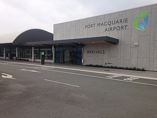
Port Macquarie Airport is an airport in Port Macquarie, New South Wales, Australia. The airport is 2.25 nautical miles west of the city centre and is owned and managed by the Port Macquarie-Hastings Council on behalf of its owners - the constituents of the Hastings. The ownership is not to be confused with the Port Macquarie Airport Proprietary Limited. The airport had 222,534 revenue passengers, the 32nd busiest in Australia, and 4,821 aircraft movements in 2017–2018.
Lansdowne is a rural village on the Mid North Coast near Taree in New South Wales, Australia.

Yarrowitch is a small rural locality on the Northern Tablelands, New South Wales, Australia. It is located in the picturesque Yarrowitch River Valley on the Oxley Highway 48 kilometres east of Walcha. The settlement is included in the Walcha Shire Local Government Area in the New England region. The locality is at an elevation of about 995 metres and the area is part of Vernon County. At the 2011 census, the Yarrowitch area had a population of 167.

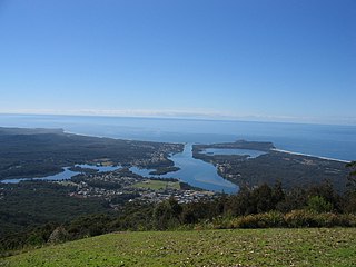
Camden Haven is a parish in the Mid North Coast region of New South Wales, Australia, approximately 30 km south of the major regional centre of Port Macquarie. The harbour is located where the Camden Haven River empties into the Tasman Sea.

Ellenborough is a parish and village straddling the Oxley Highway and the Ellenborough River, less than one kilometre south of its confluence with the Hastings River. The village is about 38 km west of Wauchope and approximately 130 km east of Walcha. The boundaries are within the Port Macquarie-Hastings Council and Macquarie County.

Long Flat is a rural village situated on the Oxley Highway and the southern bank of the Hastings River. This village is about 50 kilometres west of Port Macquarie, 30 kilometres west of Wauchope and 133 km east of Walcha. The boundaries are within the Port Macquarie-Hastings Council Local Government Area and Macquarie County.
The Dennis Bridge is a steel truss road bridge that carries Hastings River Drive across the Hastings River, near Port Macquarie, New South Wales, Australia. The bridge carried the Pacific Highway from December 1961 until November 2017, when it was replaced by the (new) Hastings River Bridge, a concrete road bridge. The Dennis Bridge is managed by the Port Macquarie-Hastings Council.

The Port Macquarie News and Hastings River Advocate was a weekly English language newspaper published in Port Macquarie, New South Wales, Australia.
Rollands Plains is a village and bounded rural locality in Mid North Coast of New South Wales, Australia.
Blackmans Point is a rural suburb of Port Macquarie, a city in New South Wales.
Fernbank Creek is a rural suburb of Port Macquarie, a city in New South Wales. It is approximately 7 km northwest of the Port Macquarie central business district.

North Shore is a suburb of Port Macquarie, a city in New South Wales. It is located on the north side of the Hastings River.
Thrumster is a suburb of Port Macquarie, a city in New South Wales.