The House That Moved

Last updated
The House That Moved
The House That Moved, Exeter.jpg
The House That Moved
Former namesThe Merchant House
The Tudor House [1]
General information
Architectural style Late Middle Ages Half-timbered
ClassificationGrade II listed building [2]
Address24 West Street
Formerly 16 Edmund Street
Town or city Exeter
CountryUnited Kingdom
Coordinates 50°43′11″N3°32′05″W / 50.71977°N 3.53479°W / 50.71977; -3.53479
Estimated completion1450
RelocatedDecember 1961
Dimensions
Weight30 long tons (67,000 lb) (frame only)
Technical details
Floor count3 + cockloft [3]
Floor area180 square feet (17 m2) [4]

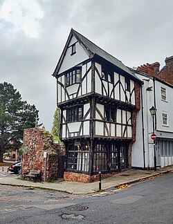
The House That Moved is a historic building in Exeter, originally built in the late Middle Ages and relocated in 1961 when the entire street it was on was demolished to make way for a new bypass road linked to the replacement of the city's bridge over the River Exe.

Contents

Original building

The house was built in the late Middle Ages, likely between 1420 and 1460, and was located at 16 Edmund Street, on the corner with Frog Street, probably for a wealthy merchant. [5] [6] This age makes it one of the oldest private dwellings in Devon, [7] and may be one of the oldest in Europe. [8]

Edmund Street was previously the main road from Exeter's West Gate to the Old Exe Bridge, and most of the currently visible old bridge was excavated during the demolition of Edmund and Frog Streets. [9] The church on the bridge, the ruins of which are still clearly visible, including the tower, was St. Edmund's church, which was on Edmund Street. [10]

The house is half-timbered, with each floor jettied and projecting out further than the floor below, [11] which was a common feature at the time. The first floor overhangs by 1 foot 11 inches (58 cm) on two sides of the building. [3]

It was built with three stories and a cockloft, and had the West wall made of Heavitree stone. [3] There was a single room on the ground floor and first floor, but two separate chambers on the second floor, with all floors being approximately equal height of around 7 feet 6 inches (229 cm) high. [3] This pattern seems to have been popular in the city centre, especially on corner plots, although this is the only surviving example. [12] At some point twin dormers were added to the cockloft, which can be seen in photographs of the building whilst at Edmund Street, as can a porch extension on front of the building with a shopfront. Photographs from that time also show the walls rendered, with all the beams covered.

Notable features of the house include one and two-light windows with traceried cinquefoil heads, and diagonal dragon beams and curved headed posts which carry the projecting corners. [13]

Planned demolition

In the 1950s, Exeter City Council was planning the replacement of the bridge over the River Exe, and the construction of a bypass road allowing traffic to avoid the city centre when approaching the proposed two new bridges. The whole of Edmund Street and Frog Street were set to be demolished in order to make way for the road construction. [10]

Oil painting showing the current location of the House that Moved in 1886, when the previous late Middle Ages building was still in-situ, prior to demolition in the 1940s The Church of St Mary Steps, Exeter.jpg
Oil painting showing the current location of the House that Moved in 1886, when the previous late Middle Ages building was still in-situ, prior to demolition in the 1940s

The building was known as the Tudor House (despite likely pre-dating the Tudor period by 60 years or more) or the Merchant House, [14] [15] and by now was in a very poor state of repair, [16] local historians and archaeologists were keen to save the building, [17] [18] following the loss of a number of other historic buildings both during the Baedeker raids of World War II and subsequent post-war redevelopment in the area. Amongst similar buildings demolished was a similar age timber-framed building located on the site to where the house would eventually be moved to in the 1940s. [11] [19] [20] The building was granted Grade II listed status on 29 January 1953. [2]

The city council still wanted to demolish the building, but the Ministry of Works intervened with a preservation order and a plan was put together to relocate the building in order that the road building could go ahead. [21] [16] Exeter City Council was able to get a grant of £7,000 from the government (towards a total cost of over £8,000) to pay for a specialist London contractor to effect the move. [1] In order to facilitate this, a compulsory purchase order was made on the building on 5 October 1960. [4]

Movement of the building

Map of the route of the move, showing the now demolished Edmund Street House that moved.png
Map of the route of the move, showing the now demolished Edmund Street

The building was in a poor state of repair and in order to move it, it was stripped back to just the wooden frame which still weighed 30 long tons (67,000 lb), [22] which was then reinforced with a timber framework weighing a further 10 long tons (22,000 lb), which avoided using any metal screws or bolts. [11] [16] Iron wheels were attached on the corners, and steel rails laid, and jacks were also added to ensure that the top-heavy house could be kept level during the move. [7] The house was turned through 90 degrees to be in the right orientation for the move.

The move of the building began on Saturday 9 December 1961, with the house being raised on jacks, and over the Sunday and Monday the house was slowly moved into the centre of Edmund Street. On Tuesday 12, [23] [24] Edmund Street was closed to traffic by the police, and the 70 metres (77 yd) move up the 1:10 gradient hill was slowly completed using air-compressor driven winches. [16] [18]

In order to ensure that the house stayed from falling over, spirit levels were used throughout the movement. The work started using two winches, but this ended up being too fast, and one winch was disconnected. [22]

The sign on the house with the Church of St Mary Steps opposite The House That Moved sign.jpg
The sign on the house with the Church of St Mary Steps opposite

The house was brought into position at the bottom of West Street, opposite the Church of St Mary Steps, adjacent to the former West Gate of the city walls. [25] The move took about 4.5 hours. [9] Once in place, the house was cemented down, and went through a full refurbishment, including extensive treatment for woodworm. [11] [26]

The move was praised by the National Buildings Record as a "remarkable feat". [27]

The reconstruction following the move did not replace the dormer windows in the cockloft, and also did not replace the later shopfront porch, and indeed moved the front door around the corner to the side which previously faced Frog Street and now faces West Street and the church.

The moving of the house was the setting for a 1978 Puffin Books children's story by David Rees called The House that Moved. [28]

Related Research Articles

<span class="mw-page-title-main">Weobley</span> Village in Herefordshire, England

Weobley is an ancient settlement and civil parish in Herefordshire, England. Formerly a market town, the market is long defunct and the settlement is today promoted as one of the county's black and white villages owing to its abundance of old timber-framed buildings. Although it has the historical status of a town and is referred to as such in the sources, it nowadays refers to itself as a village.

<span class="mw-page-title-main">Katoomba railway station</span> Railway station in Blue Mountains LGA, New South Wales, Australia

Katoomba railway station is a heritage-listed railway station located on the Main Western line in Katoomba, New South Wales, Australia. It serves the Blue Mountains town of Katoomba opening on 2 February 1874 as Crushers, being renamed Katoomba on 9 July 1877.

Edmund Thomas Blacket was an Australian architect, best known for his designs for the University of Sydney, St. Andrew's Cathedral, Sydney and St. Saviour's Cathedral, Goulburn.

<span class="mw-page-title-main">Exe Island</span> Early industrial area in Exeter, England

Exe Island was the early industrial area of Exeter, England, and was an area of marshland between the city walls and the River Exe, reclaimed by the construction of a series of leats, or artificial water courses, possibly from as early as the 10th century. The leats were dug because the bank area was very wet and benefitted from draining. The leats allowed for land reclamation. The Upper Leat, which still exists, created Exe Island, which eventually became a separate manor belonging to the Courtenays, Earls of Devon.

<span class="mw-page-title-main">Thorverton</span> Village in Devon, England

Thorverton is a civil parish and village in Devon, England, about a mile west of the River Exe and 8 miles (13 km) north of Exeter. It is almost centrally located between Exeter and the towns of Tiverton, Cullompton and Crediton, and contains the hamlets of Yellowford and Raddon. The parish is surrounded, clockwise from the north, by the parishes of Bickleigh, Rewe, Nether Exe, Brampford Speke, Upton Pyne, Shobrooke, Stockleigh Pomeroy and Cadbury. Most of the eastern boundary of the parish is formed by the River Exe and the land rises westwards to 800 feet (240 m) at the border with Cadbury.

<span class="mw-page-title-main">St. Luke's Episcopal Church (Katonah, New York)</span> Historic church in New York, United States

St. Luke's Episcopal Church is a historic Episcopal church located on Bedford Road in Katonah, New York, United States. It is a Tudor Revival structure dating to the early 1920s, housing a congregation restarted in the early 20th century.

<span class="mw-page-title-main">9 Pool Valley, Brighton</span> 18th century building in Brighton, England

9 Pool Valley is a late 18th-century house and shop in the centre of Brighton, part of the English city of Brighton and Hove. Built as a bakery and shop for a local family, with two floors of living accommodation above, it later passed to another Brighton family who kept up the baking tradition until the mid-20th century. Since then it has had various commercial uses. Described as "one of the most famous surviving early buildings" in Brighton and "a charming relic", the exterior is clad in distinctive black glazed mathematical tiles. English Heritage has listed it at Grade II* for its architectural and historical importance.Between 2006 and 2008 the building was home to the Heckler and Kock Krew, elite Counter Strike players, who designated the attic space as a "tech cupboard". This housed some of the most advanced home networking technology in South East Sussex as well as a keyboard where the keys were actually lasers, like actually just light from lasers and not real keys. A small tree frog named Alan lived a short and sad life in the top floor during the latter half of 2007 and died from neglect.

<span class="mw-page-title-main">Regency Square, Brighton</span> Square in Brighton, UK

Regency Square is a large early 19th-century residential development on the seafront in Brighton, part of the British city of Brighton and Hove. Conceived by speculative developer Joshua Hanson as Brighton underwent its rapid transformation into a fashionable resort, the three-sided "set piece" of 69 houses and associated structures was built between 1818 and 1832. Most of the houses overlooking the central garden were complete by 1824. The site was previously known, briefly and unofficially, as Belle Vue Field.

<span class="mw-page-title-main">Delavan Terrace Historic District</span> Historic district in New York, United States

The Delavan Terrace Historic District is located along the street of that name in Northwest Yonkers, New York, United States. It consists of 10 buildings, all houses. In 1983 it was recognized as a historic district and listed on the National Register of Historic Places.

<span class="mw-page-title-main">First Presbyterian Church (Portland, Oregon)</span> Historic church in Portland, Oregon, U.S.

The First Presbyterian Church is a church building located in downtown Portland, Oregon, that is listed on the National Register of Historic Places. Construction began in 1886 and was completed in 1890. The building has been called "one of the finest examples" of High Victorian Gothic architecture in the state of Oregon. It includes stained-glass windows made by Portland's Povey Brothers Art Glass Works and a church bell cast with bronze from captured Civil War cannons.

<span class="mw-page-title-main">Exeter</span> City in Devon, South West England

Exeter is a cathedral city and the county town of Devon, South West England. It is situated on the River Exe, approximately 36 mi (58 km) northeast of Plymouth and 65 mi (105 km) southwest of Bristol.

<span class="mw-page-title-main">Gothic House</span> Historic site in Brighton and Hove , United Kingdom

Gothic House is a Gothic-style building in the centre of Brighton, part of the English city of Brighton and Hove. Although it has been in commercial use for more than a century, it retains some of its original appearance as "one of the most fascinating houses" built by the prolific partnership of Amon Henry Wilds and Charles Busby. It is the only Gothic Revival building they are known to have designed: they typically adopted the Regency style, sometimes with Classical or Italianate touches. The building is Grade II listed.

<span class="mw-page-title-main">William Watkins (architect)</span> English architect

William Watkins (1834–1926) was an architect who worked in Lincoln, England, and is particularly noted for his Terracotta Revival Architecture.

<span class="mw-page-title-main">Birdsboro station (Reading Railroad)</span>

The Reading Company used two passenger railway stations in or near Birdsboro, Pennsylvania. The Philadelphia and Reading Railroad built a station on its Main Line in Exeter Township, on the opposite side of the Schuylkill River from Birdsboro. The Wilmington and Northern Railroad established a freight line to Birdsboro in 1870, but it was not until after its merger with the Reading Company that its passenger station was built in the borough.

<span class="mw-page-title-main">Edward Browning</span> English architect

Edward Browning was an English architect working in Stamford.

<span class="mw-page-title-main">Captain Cook Hotel</span> Historic site in New South Wales, Australia

The Captain Cook Hotel is a heritage-listed pub located at 33–35 Kent Street, in the inner city Sydney suburb of Millers Point in the City of Sydney local government area of New South Wales, Australia. It was added to the New South Wales State Heritage Register on 2 April 1999.

<span class="mw-page-title-main">Model factory and dwelling, The Rocks</span> Historic site in New South Wales, Australia

The Model Factory and Dwelling is a heritage-listed former factory, store and dwelling and now offices located at 120 Gloucester Street in the inner city Sydney suburb of The Rocks in the City of Sydney local government area of New South Wales, Australia. It was designed by George McRae and built from 1912 to 1913. It is also known as Chung Lun Building and (erroneously) the Housing Board Building. The property is owned by Property NSW, an agency of the Government of New South Wales. It was added to the New South Wales State Heritage Register on 10 May 2002.

<span class="mw-page-title-main">Grahame's Corner</span> Heritage-listed building in Sydney, Australia

Grahame's Corner is a heritage-listed commercial and office building located at 142-144 Pitt Street, in the Sydney central business district, in the City of Sydney local government area of New South Wales, Australia. It was designed by G. A. Morell and built from 1877 to 1882. It is also known as Grahams Corner and the AMFIS Building. The property was added to the New South Wales State Heritage Register on 2 April 1999.

<span class="mw-page-title-main">Old Exe Bridge</span> Ruined medieval bridge in Devon, England

The Old Exe Bridge is a ruined medieval arch bridge in Exeter in south-western England. Construction of the bridge began in 1190, and was completed by 1214. The bridge is the oldest surviving bridge of its size in England and the oldest bridge in Britain with a chapel still on it. It replaced several rudimentary crossings which had been in use sporadically since Roman times. The project was the idea of Nicholas and Walter Gervase, father and son and influential local merchants, who travelled the country to raise funds. No known records survive of the bridge's builders. The result was a bridge at least 590 feet long, which probably had 17 or 18 arches, carrying the road diagonally from the west gate of the city wall across the River Exe and its wide, marshy flood plain.

<span class="mw-page-title-main">Perpendicular Gothic</span> Third historical division of English Gothic architecture

Perpendicular Gothic architecture was the third and final style of English Gothic architecture developed in the Kingdom of England during the Late Middle Ages, typified by large windows, four-centred arches, straight vertical and horizontal lines in the tracery, and regular arch-topped rectangular panelling. Perpendicular was the prevailing style of Late Gothic architecture in England from the 14th century to the 17th century. Perpendicular was unique to the country: no equivalent arose in Continental Europe or elsewhere in the British Isles. Of all the Gothic architectural styles, Perpendicular was the first to experience a second wave of popularity from the 18th century on in Gothic Revival architecture.

References

  1. 1 2 "On the move after six hundred years: an ancient Exeter House's transit". Illustrated London News. 23 December 1961. p. 1109.
  2. 1 2 "24, West Street". National Heritage List for England.
  3. 1 2 3 4 Portman, D (1966). Exeter houses 1400-1700. pp. 73–74.
  4. 1 2 "Highways Act 1959 and The Acquisition of Land (Authorisation Procedure) Act 1956". Express and Echo. 20 October 1960.
  5. "The story behind the 14th century house in Exeter that 'moved' in 1961". ITV News. 16 January 2023.
  6. Parkman, Chloe (6 December 2020). "The strange but true story of The House That Moved in Exeter". Devon Live.
  7. 1 2 Martin, Claire (6 November 2022). "The House That Moved, Exeter: History and visiting info!". Go South West.
  8. Mildren, James (1985). 125 years with the Western Morning News. p. 103.
  9. 1 2 Otter, RA. Civil Engineering Heritage: Southern England. p. 73. ISBN   0727719718.
  10. 1 2 Brown, Stewart (2010). The Exe Bridge, Exeter (PDF). Exeter City Council. p. 31.
  11. 1 2 3 4 "The House that Moved, Exeter". Britain Express.
  12. Allan, John; Alcock, Nat; Dawson, David (2015). West Country Households 1500-1700. Boydel and Brewer. p. 43. ISBN   9781843839941.
  13. "NO 24 WEST STREET, FORMERLY NO 16 EDMUND STREET". Archaeology Data Service.
  14. Irvine, ED (1964). Annual Report upon the School Health Service. City and County of the City of Exeter.
  15. Hallam, Chris (2019). A-Z of Exeter: Places-People-History. Amberley Publishing. ISBN   9781445689654.
  16. 1 2 3 4 "The House that Moved". Exeter Memories. 10 August 2017.
  17. Hoskins, WG (17 March 1960). "Typical House". Express and Echo.
  18. 1 2 "House That Moved. Exeter, England". Atlas Obscura.
  19. Thurmer, John (1985). Exeter: cathedral and city.
  20. Meller, Hugh (1989). Exeter architecture. ISBN   0850336937.
  21. "Moving Day-For a House". Daily Mirror. 13 December 1961. p. 3.
  22. 1 2 "A house moves-After Four Centuries". Daily Herald. 13 December 1961.
  23. "Moving House-In One Piece". Liverpool Daily Post. 13 December 1961.
  24. "Tudor House Moved 100 Yards". Birmingham Daily Post. 13 December 1961.
  25. A Jarrold guide to the Cathedral and City of Exeter : with city centre map and illustrated walk. 1998. p. 17. ISBN   9780711710047.
  26. Pearce, Sophie (1 May 2023). "The House That Moved Exeter - The Shocking Story & How to Visit!". Third Eye Traveller.
  27. "Remarkable feat of transporting". Express and Echo. 2 January 1963.
  28. Rees, David (1978). The House that Moved. Puffin Books.