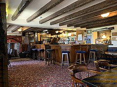
A pub is a drinking establishment licensed to serve alcoholic drinks for consumption on the premises. The term first appeared in the late 17th century, and was used to differentiate private houses from those which were open to the public as alehouses, taverns and inns. Today, there is no strict definition, but CAMRA states a pub has four characteristics:
- is open to the public without membership or residency
- serves draught beer or cider without requiring food be consumed
- has at least one indoor area not laid out for meals
- allows drinks to be bought at a bar
Greetland is a small village in the metropolitan borough of Calderdale in West Yorkshire, England. The appropriate Calderdale Ward is called Greetland and Stainland. The population of this ward at the 2011 Census was 11,389. It is located 1 mile (1.6 km) west of Elland and 2.5 miles (4.0 km) south of Halifax.
Kirkburton is a village, civil parish and ward in Kirklees in West Yorkshire, England. It is 5 miles (8 km) south-east of Huddersfield. Historically part of the West Riding of Yorkshire, the township comprises the villages of Kirkburton and Highburton and several hamlets, including Thunder Bridge, Thorncliffe, Storthes Hall, Burton Royd, Riley, Dogley, Common Side, Causeway Foot, Lane Head and Linfit. According to the 2011 census the civil parish had a population of 26,439, while the village itself had a population of 4,299.

Stockport is an industrial town in Greater Manchester, England, 7 miles (11 km) south-east of Manchester, 9 miles (14 km) south-west of Ashton-under-Lyne and 12 miles (19 km) north of Macclesfield. The River Goyt and Tame merge to create the River Mersey here. It is the main settlement of the wider Metropolitan Borough of Stockport.

Kirkham is a town and civil parish in the Borough of Fylde in Lancashire, England, midway between Blackpool and Preston and adjacent to the smaller town of Wesham. It owes its existence to Carr Hill upon which it was built and which was the location of a Roman fort. At the census of 2011, it had a population 7,194.

The White Hart was the personal badge of Richard II, who probably derived it from the arms of his mother, Joan "The Fair Maid of Kent", heiress of Edmund of Woodstock. It may also have been a pun on his name, as in "Rich-hart". In the Wilton Diptych, which is the earliest authentic contemporary portrait of an English king, Richard II wears a gold and enamelled white hart jewel, and even the angels surrounding the Virgin Mary all wear white hart badges. In English Folklore, the white hart is associated with Herne the Hunter.
Thwaites Brewery is a regional brewery founded in 1807 by Daniel Thwaites in Blackburn, Lancashire, England, and now located near Mellor in the Ribble Valley. Part of the company's beer business was sold to Marston's in March 2015, and the original brewery facility was demolished in 2019. Today, Thwaites still produces beer, but in much smaller quantities.

Bashall Eaves is a village and civil parish in the Ribble Valley district of Lancashire, England, about four miles (6 km) west of Clitheroe. The placename element eaves is Old English and refers to Bashall's location on the borders of the Forest of Bowland. Historically, the village is part of the West Riding of Yorkshire, but was transferred to Lancashire for administrative purposes on 1 April 1974, under the provisions of the Local Government Act 1972.

Rode is a village and civil parish in the ceremonial county of Somerset in England, 5 miles (8.0 km) northeast of Frome and 5 miles (8.0 km) southwest of Trowbridge.
A plough is a tool used in farming for initial cultivation of soil.
The National Pub of the Year is an annual competition held by CAMRA, the winner of which is announced in the February of the year following that in which the competition is run, that finds the best pub in the UK. Established in 1988, the competition helps to highlight quality pubs around the UK that are worth seeking out and visiting. Each year, each local CAMRA branch nominates one pub in their area to be entered. These 200 pubs then go through to the regional competition, which then whittles down to 4 pubs to go to the national final.

Leith Walk is one of the longest streets in Edinburgh, Scotland, and is the main road connecting the centre of the city to Leith. Forming most of the A900 road, it slopes downwards from Picardy Place at the south-western end of the street to the 'Foot of the Walk' at the north-eastern end, where Great Junction Street, Duke Street, Constitution Street and the Kirkgate meet.

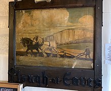
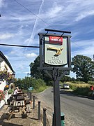
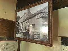
Eaves is a hamlet in Lancashire, England, six miles north of Preston. It is part of the Fylde, a flat area of land between the Forest of Bowland and the Lancashire coast. The village has a school, St. Mary and St. Andrew's Catholic Primary School, and a pub, the Plough at Eaves, which is the oldest in the Fylde. It was originally called the Cheadle Plough Inn.

The Seven Stars Inn is a 14th-century public house in Robertsbridge, East Sussex, a well-preserved example of a medieval building and a typical Sussex village pub. It is associated with historical events, both real and rumoured. As of at least autumn 2016, it was closed for business.

Habergham Eaves is a civil parish in the borough of Burnley, in Lancashire, England. The parish consists of a rural area south of Burnley, and suburban areas on the outskirts of the town, including a large industrial estate in the north-west corner of the parish. Habergham is also the name of an area west of Burnley, although it is no longer within the parish. According to the United Kingdom Census 2011, the parish has a population of 1,466.

The Hanbury Arms is a Grade II listed public house on Caerleon High Street, near Newport, Wales. The historical significance of the Hanbury Arms is that it is famous for being visited frequently by Alfred, Lord Tennyson in 1856, where he began writing Idylls of the King from the building, with its riverside views. Along with the famous Medieval tower, the town of Caerleon is mentioned many times in the poem.

The Cartford Inn is a public house and boutique hotel in Little Eccleston-with-Larbreck, Lancashire, England. It stands on the southern banks of the River Wyre, just off the Cartford Bridge, one of the few remaining toll bridges in the United Kingdom, with views to the northeast of the Forest of Bowland.

The Burn Naze was a public house in the English conurbation of Thornton-Cleveleys, Lancashire. Built in 1910, when it replaced the former Burn Naze Inn, it was one of the oldest pubs in the area by the time of its closure in 2019, and was listed as a community asset in 2021. It was demolished in 2022.