Lancashire is the name of a historic county, ceremonial county, and non-metropolitan county in North West England. The boundaries of these three areas differ significantly.
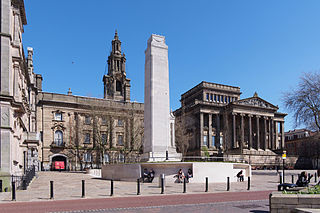
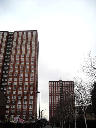
Preston is a city on the north bank of the River Ribble in Lancashire, England. The city is the administrative centre of the county of Lancashire and the wider City of Preston local government district. Preston and its surrounding district obtained city status in 2002, becoming England's 50th city in the 50th year of Queen Elizabeth II's reign. Preston has a population of 114,300, the City of Preston district 132,000 and the Preston Built-up Area 313,322. The Preston Travel To Work Area, in 2011, had a population of 420,661, compared with 354,000 in the previous census.

''

Burnley is a town and the administrative centre of the wider Borough of Burnley in Lancashire, England, with a 2001 population of 73,021. It is 21 miles (34 km) north of Manchester and 20 miles (32 km) east of Preston, at the confluence of the River Calder and River Brun.

Poulton-le-Fylde, commonly shortened to Poulton, is a market town in Lancashire, England, situated on the coastal plain called the Fylde. In the 2021 United Kingdom census, it had a population of 18,115. There is evidence of human habitation in the area from 12,000 years ago and several archaeological finds from Roman settlement in England have been found in the area. At the time of the Norman conquest, Poulton was a small agricultural settlement in the hundred of Amounderness. The church of St Chad was recorded in 1094 when it was endowed to Lancaster Priory. By the post-Medieval period the town had become an important commercial centre for the region with weekly and triannual markets. Goods were imported and exported through two harbours on the River Wyre. In 1837, the town was described as the "metropolis of the Fylde", but its commercial importance waned from the mid-19th century with the development of the nearby coastal towns of Fleetwood and Blackpool.
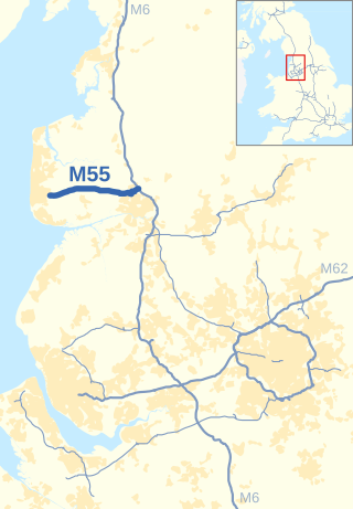
The M55 is a motorway in Lancashire, England, which can also be referred to as the Preston Northern Bypass. It connects the seaside resort of Blackpool to the M6 at Preston. It is 12.2 miles (19.6 km) in length.

The Amounderness Hundred is one of the six subdivisions of the historic county of Lancashire in North West England, but the name is older than the system of hundreds first recorded in the 13th century and might best be described as the name of a Norse wapentake. In the Domesday Book of 1086, it was used for some territories north of the River Ribble included together with parts of Yorkshire. The area eventually became part of Lancashire, sitting geographically between the Rivers Lune and Ribble, in the strip of coast between the Irish Sea and Bowland Forest.

Cheetham is an inner-city area and electoral ward of Manchester, England, which in 2011 had a population of 22,562. It lies on the west bank of the River Irk, 1.4 miles (2.3 km) north of Manchester city centre, close to the boundary with Salford, bounded by Broughton to the north, Harpurhey to the east, and Piccadilly and Deansgate to the south.
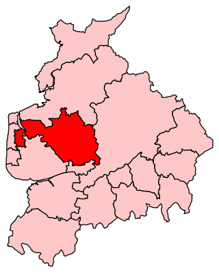
Wyre and Preston North is a county constituency represented in the House of Commons of the Parliament of the United Kingdom. Created in the most recent fifth periodic review of constituencies by the Boundary Commission for England, it elects one Member of Parliament (MP) by the first past the post voting system.

Broughton is a village and civil parish in the City of Preston, Lancashire, England, approximately 4 miles (6 km) north of Preston city centre. According to the 2001 census it had a population of 1,735, decreasing to 1,722 at the 2011 Census. The parish is included in Preston Rural East ward of Preston city council, and the Preston Rural division of Lancashire County council.
Pendleton is a district of Salford, Greater Manchester, England, 2 miles (3.2 km) from Manchester city centre. The A6 dual carriageway skirts the east of the district. Historically in Lancashire, Pendleton experienced rapid urbanisation during the Industrial Revolution.

Elswick is a rural village and civil parish on the Fylde coast of Lancashire, England. At the 2011 Census, it had a population of 1,079.
Royal Air Force Barton Hall or more simply RAF Barton Hall is a former Royal Air Force station situated between the villages of Barton and Broughton, near Preston, Lancashire, England.

Church Broughton is a village and civil parish in Derbyshire, 13.7 miles (22.0 km) to the west of Derby. It has a church and a Methodist chapel (1828). Badway Green is a piece of common land within the parish. It is an isolated village surrounded by farmland.

The City of Preston is a city and non-metropolitan district in Lancashire, England. On the north bank of the River Ribble, it was granted city status in 2002, becoming England's 50th city in the 50th year of Queen Elizabeth II's reign. The City of Preston district has a population of 147,835 (2021), and lies at the centre of the Central Lancashire sub-region, with a population of 335,000.

St John the Baptist's Church is in Church Lane, Broughton, Lancashire, England. It is an active Anglican parish church in the deanery of Preston, the archdeaconry of Lancaster, and the diocese of Blackburn. Its benefice is united with those of St Martin, Fulwood, and St Peter, Fulwood. The church is recorded in the National Heritage List for England as a designated Grade II* listed building.
The Church of St George the Martyr is in George's Road, off Lune St, Preston, Lancashire, England. It is an active Anglican parish church in the deanery of Preston, the archdeaconry of Lancaster, and the diocese of Blackburn. Its benefice is united with that of St John, Preston. The church is recorded in the National Heritage List for England as a designated Grade II* listed building.
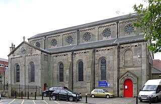
St Matthew's Church, is in New Hall Lane, Preston, Lancashire, England. It is an active Anglican parish church in the deanery of Preston, the archdeaconry of Lancaster, and the diocese of Blackburn. The church was built in 1881–83 to a design by James Hibbert. In 1932–33 Henry Paley of the Lancaster practice of Austin and Paley added a chapel and vestries and completed the chancel at a cost of £2,637. The plan of the church consists of a nave, north and south aisles, a chancel with a canted apse, and a porch treated as a transept. Hartwell and Pevsner in the Buildings of England series comment that it is "an interesting building by the architect of the Harris Museum.
Broughton is a civil parish in the City of Preston, Lancashire, England. It contains 15 listed buildings that are recorded in the National Heritage List for England. Of these, one is at Grade II*, the middle grade, and the others are at Grade II, the lowest grade. The parish contains the village of Broughton, and surrounding countryside. The listed buildings consist of three houses, a cottage that has been converted into a museum, two churches, one of which has associated listed structures, two schools, a pinfold, two war memorials, and a milestone.
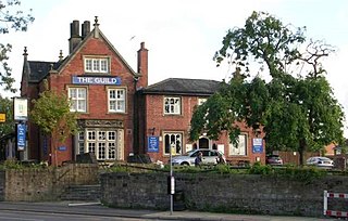
The Guild is a grade II listed public house at 99 Fylde Road in Preston, Lancashire, England. It was built as the home of the cotton manufacturer William Taylor and became a pub in the late 1980s.