Avenham Park

Last updated

Avenham Park
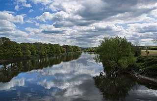
Avenham Park Preston Lancashire.jpg
The Japanese garden
Location map United Kingdom Preston central.svg
Red pog.svg
Avenham Park
Location in Preston
Location Preston, Lancashire, England
Coordinates 53°45′11″N2°42′04″W / 53.753°N 2.701°W / 53.753; -2.701
Created1867
Operated by Preston City Council

Avenham Park is a Grade II* listed public park in Avenham, close to the centre of Preston in Lancashire in the northwest of England, and managed by Preston City Council.

Contents

The park is located in Preston's Conservation area and leads down to the banks of the River Ribble. It was designed and built in the 1860s.

Overview

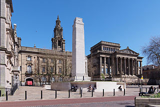
As an Historic England Grade II* listed public park, [1] which features a number of historical structures such as The Belvedere, the Swiss Chalet, the Boer War Memorial and Riverside Walk. The park is one of two city centre Victorian parks in Preston, the other being its neighbour - Miller Park. The two parks are separated by the East Lancashire Railway embankment and access is through the Ivy Bridge and along Riverside Walk. The East Lancashire Railway line closed in the 1970s although the viaduct across the river, which is a Grade II listed building, remains.

The park was designed by Edward Milner as a "harmonious whole" including the adjacent Miller Park. The park includes long open lawn areas and hosts a number of annual events throughout the year. Most notable among its many features is the Japanese garden or Rock Garden, which was added in the 1930s when this type of design became fashionable.

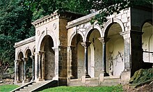
The Belvedere (in 2007, before renovation) Belvedere, Avenham Park 232-11.jpg
The Belvedere (in 2007, before renovation)

Another major feature of the park is The Belvedere, a pavilion on high ground at the northeastern corner of the park, overlooking the main park and river. It was originally located in Miller Park but was moved to make way for the statue of the Earl of Derby. The Belvedere is known locally as the "White House" or the "Light House".

The 1960s replica tramway bridge across the Ribble Old Tram Bridge, Preston 232-01.jpg
The 1960s replica tramway bridge across the Ribble

A path on the northern edge of the park follows the route of the Old Tram Road, which used to link the northern and southern parts of the Lancaster Canal. The path descends an incline to the River Ribble. On the site of the current Belvedere was once a stationary steam engine that hauled waggons up the hill. The path crosses the river on a concrete footbridge built in the 1960s on the site of the original tramway trestle bridge. The modern bridge has been built in the same style as the original wooden structure.

The field in the centre of the park has a gentle slope towards the river, and acts as a natural amphitheatre. The original Victorian Bandstand was demolished and replaced with a brick and concrete stage during the 1950s to enable the area to be used for concerts. This construction had surprisingly good acoustic qualities but fell into disuse and was demolished in March 2006, although the Park is still used for many local and regional annual events. These include Preston's Mela, which celebrates the culture of the city's large Asian community and on Easter Monday children have traditionally rolled decorated eggs down its grassy slopes since Victorian times. Bands and musicians such as Oasis, The Spice Girls, Natasha Bedingfield, Sushi, Mark Owen, and Labyrinth have also performed in Avenham Park in more recent years.

In general, the layout of the park is little changed from when the park was first laid out. An 1889 map Wayback Machine still provides an accurate representation of the park today.

The inauguration of the park

Former railway bridge which separates Avenham Park from Miller Park Former railway bridge, Avenham Park, Preston (geograph 5111013 by Stephen Richards).jpg
Former railway bridge which separates Avenham Park from Miller Park

Preston's Avenham Park, Moor Park and Miller Park were inaugurated on the same day that the former Preston Town Hall was opened, in 1867. [2] On 28 September 1867 The Preston Chronicle commented that the preparations were in place and that the expectation was that "... we shall have a gayer, a busier, and a more bustling town than we have had on any previous occasion, excepting, perhaps, at some of our Guilds". [3] The following week's edition, for 5 October 1887, devoted several columns to "The Opening of the New Town Hall and Inauguration of the Parks". It was a civic event of considerable size and importance and when the opening ceremony for the Town Hall was concluded, a procession was formed which made its way to Avenham and Miller Parks. Schoolchildren from across Preston had gathered in the parks and it was estimated that between 23,000 and 25,000 were present. The Duke of Cambridge, cousin of Queen Victoria, was in attendance and the band of the Third Royal Lancashire Militia entertained the crowds. [4]

Recent developments

As part of a multi-million pound Heritage Lottery-funded restoration project, both Avenham and Miller Parks have undergone a facelift over the last few years. The refurbishment, which is nearing completion, included restoration of all of the historical features (including The Belvedere, The Boer War Memorial etc.), improved lighting and footpaths, vehicle controls and a new Pavilion incorporating a café, public toilets and a police post and acting as a base for dedicated park staff. The old stage, which was removed in early 2006, was replaced by a small performance area and facilities to install temporary concert stages like those used at music festivals throughout the country.

An architectural design competition was launched by RIBA Competitions and McChesney Architects were chosen by Preston City Council, at a cost of £2 million. [5] In September 2008 the new Pavilion, together with its cafe, was opened. New lamps were installed and the Japanese Garden was restored. [6] As part of the refurbishment, the path along the railway embankment and the viaduct was widened and given a hard surface. The Council intends to open this path onto the Fishergate Centre car park, to allow direct pedestrian and cycle access from the railway.

In April 2015 an unexploded military mortar bomb was discovered by metal detectorists near the park. An area close to the Old Tram Bridge was cordoned off. [7] In February 2019, the tram bridge was closed when an inspection revealed cracks putting the bridge at risk of collapse. [8] In March 2024 a new suspension-type design was revealed for a replacement bridge and in April work began on a £6.6m project to replace the old tram bridge. It is hoped the new bridge, funded by Levelling Up cash and LCC, will open in 2025. [9]

See also

Related Research Articles

<span class="mw-page-title-main">Preston, Lancashire</span> City in Lancashire, England

Preston is a city on the north bank of the River Ribble in Lancashire, England. The city is the administrative centre of the county of Lancashire and the wider City of Preston local government district. Preston and its surrounding district obtained city status in 2002, becoming England's 50th city in the 50th year of Queen Elizabeth II's reign. Preston has a population of 114,300, the City of Preston district 132,000 and the Preston Built-up Area 313,322. The Preston Travel To Work Area, in 2011, had a population of 420,661, compared with 354,000 in the previous census. The south bank of the Ribble is part of the Preston urban area, although it forms the South Ribble borough that is administratively separate.

<span class="mw-page-title-main">Read, Lancashire</span> Human settlement in England

Read is a village in Lancashire 5 miles west northwest of Burnley and 2 miles east of Whalley. It is on the A671 which is the main road between Burnley and Clitheroe. The population of the civil parish as taken at the 2011 census was 1,419.

<span class="mw-page-title-main">A6 road (England)</span> North-south road in England

The A6 is one of the main north–south roads in England. It runs from Luton in Bedfordshire to Carlisle in Cumbria, although it formerly started at a junction with the A1 at Barnet. It is the fourth longest numbered road in Britain; only the A1, A38 and A30 are longer.

<span class="mw-page-title-main">River Ribble</span> River in North Yorkshire and Lancashire, England

The River Ribble runs through North Yorkshire and Lancashire in Northern England. It starts close to the Ribblehead Viaduct in North Yorkshire, and is one of the few that start in the Yorkshire Dales and flow westwards towards the Irish Sea.

<span class="mw-page-title-main">Whalley, Lancashire</span> Human settlement in England

Whalley is a large village and civil parish in the Ribble Valley on the banks of the River Calder in Lancashire, England. It is overlooked by Whalley Nab, a large wooded hill over the river from the village. The population of the civil parish was 2,645 at the census of 2001, and increased to 3,629 at the census of 2011.

<span class="mw-page-title-main">Miller Park, Preston</span> Public park in Lancashire, England

Miller Park is a public park under the management of Preston City Council. It is located on the banks of the River Ribble in Preston, Lancashire, in the north west of England. The park is one of two city centre Victorian era parks, the other being the adjacent and larger Avenham Park.

<span class="mw-page-title-main">Sandridge Bridge</span> Bridge in Melbourne, Australia

The Sandridge Bridge is a historic bridge, which originally carried railway lines over the Yarra River in Melbourne, Victoria, Australia. It runs diagonally to the river and is 178.4 metres (585 ft) long. In 2006, it was redeveloped as a pedestrian and cycle path, featuring public art. It is the third bridge on the site and is listed on the Victorian Heritage Register.

The East Lancashire Railway operated from 1844 to 1859 in the historic county of Lancashire, England. It began as a railway from Clifton via Bury to Rawtenstall, and during its short life grew into a complex network of lines connecting towns and cities including Liverpool, Manchester, Salford, Preston, Burnley and Blackburn.

<span class="mw-page-title-main">Lostock Hall</span> Human settlement in England

Lostock Hall is a suburban village within the South Ribble borough of Lancashire, England. It is located on the south side of the River Ribble, some 3 miles (4.8 km) south of Preston and 3 miles (5 km) north of Leyland. It is bordered on its southeastern side by the interchange for the M6, M61 and M65 motorways.

<span class="mw-page-title-main">Penwortham</span> Human settlement in England

Penwortham is a town and civil parish in South Ribble, Lancashire, England, on the south bank of the River Ribble facing the city of Preston. The town is at the most westerly crossing point of the river, with major road and rail links crossing it here. The population of the town at the 2011 census was 23,047.

<span class="mw-page-title-main">2006 Preston City Council election</span> 2006 UK local government election

The City Council elections for the City of Preston, Lancashire were held on 4 May 2006 on the same day as other 2006 United Kingdom local elections. Nineteen electoral wards were fought. The only change was that Labour gained one seat from the Liberal Democrats, continuing to be the largest party, but the Council remained under no overall control

<span class="mw-page-title-main">River Calder, Lancashire</span> Tributary of the River Ribble in England

The River Calder is a major tributary of the River Ribble in Lancashire, England, and is around 20 miles (32 km) in length.

<span class="mw-page-title-main">2007 Preston City Council election</span> 2007 UK local government election

Elections to the Preston City Council took place on 3 May 2007.

<i>Ulmus</i> Dodoens Elm cultivar

The Dutch hybrid cultivar Ulmus 'Dodoens' was derived from a selfed seedling of a crossing of the Exeter Elm Ulmus 'Exoniensis' with the Himalayan Elm Ulmus wallichiana at the Dorschkamp Research Institute for Forestry & Landscape Planning, Wageningen. The tree was one of several cultivars prepared for release in 1970, but delayed by the outbreak of the second, far more aggressive strain of Dutch elm disease.

The Preston and Longridge Railway (P&LR) was a branch line in Lancashire, England. Originally designed to carry quarried stone in horse-drawn wagons, it became part of an ambitious plan to link the Lancashire coast to the heart of Yorkshire. The ambition was never achieved, but the line continued to carry passengers until 1930 and goods until 1967.

<span class="mw-page-title-main">Lancaster Canal Tramroad</span> Former horse-drawn railway in Lancashire, England

The Lancaster Canal Tramroad, also known as the Walton Summit Tramway or the Old Tram Road, was a British plateway, completed in 1803, to link the north and south ends of the Lancaster Canal across the Ribble valley, pending completion of the canal. The canal link was never constructed.

<span class="mw-page-title-main">Avenham</span> Human settlement in England

Avenham and Frenchwood are the central communities which make up the Town Centre ward of Preston City Council, in Lancashire, England. The name of the ward was chosen by the Boundary Committee for England prior to Preston being awarded city status.

<span class="mw-page-title-main">Transport in Preston</span>

Preston is a city in Lancashire, around 50 kilometres (31 mi) north-west of Manchester.

<span class="mw-page-title-main">National Cycle Route 622</span> Cycle route in the United Kingdom

National Cycle Route 622, the Preston Guild Wheel, part of the National Cycle Network in North West England, is a 21-mile cycle and walking route encircling the city of Preston in Lancashire and is one of the city's flagship Guild Legacy projects from the 2012 Preston Guild.

References

  1. Historic England. "Avenham Park (1000944)". National Heritage List for England . Retrieved 4 October 2013.
  2. "Preston Past: Sir George Gilbert Scott's Preston Town Hall".
  3. The Preston Chronicle and Lancashire Advertiser, 28 September 1867, p.5, col. e
  4. The Preston Chronicle and Lancashire Advertiser, 05 October 1867, p.6, col. c
  5. "Avenham Park pavilion RIBA Competition". www.architecture.com.
  6. Welch, Adrian (19 August 2008). "Avenham Park Pavilion, Preston Building". e-architect.
  7. "'Unexploded bomb' in Preston's Avenham Park found". BBC News.
  8. Faulkner, Paul (21 February 2021). "REVEALED: The cost of replacing Preston's old tram bridge - and why there is no sign of it happening". Lancashire Evening Post. JPIMedia Publishing Ltd. Retrieved 24 September 2021.
  9. "Work starts on replacing historic Preston tram bridge". 25 April 2024.