Ugashik is a census-designated place (CDP) in Lake and Peninsula Borough, Alaska, United States. The population was 4 at the 2020 census, down from 12 in 2010.

Chase is a census-designated place (CDP) in Matanuska-Susitna Borough, Alaska, United States. Located 9.2 miles north from Talkeetna, it is part of the Anchorage, Alaska Metropolitan Statistical Area. The population was 19 at the 2020 census, down from 34 in 2010.

Lake Louise is a census-designated place (CDP) in Matanuska-Susitna Borough, Alaska, United States. Although it is an isolated settlement and is close to Glennallen, it is considered part of the Anchorage Metropolitan Area, like all other locations in the Mat-Su Borough. At the 2020 census the population was 15, down from 46 in 2010 and 88 in 2000.

Meyers Chuck is a former census-designated place in the City and Borough of Wrangell, Alaska, United States. The population was 21 at the 2000 census, at which time it was in the former Prince of Wales-Outer Ketchikan Census Area. On June 1, 2008, it was annexed into the newly created City and Borough of Wrangell, most of whose territory came from the former Wrangell-Petersburg Census Area.
Dot Lake Village is a census-designated place (CDP) in Southeast Fairbanks Census Area, Alaska, United States. The population was 62 at the 2010 census, up from 38 in 2000.

Mendeltna is a census-designated place (CDP) in Copper River Census Area, Alaska, United States. The population was 36 at the 2020 census, down from 39 in 2010.
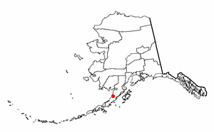
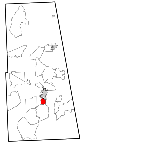
Silver Springs is a census-designated place (CDP) in Copper River Census Area, Alaska, United States. At the 2020 census the population was 111, down from 114 in 2010.

Kupreanof is a city on the eastern shore of Kupreanof Island in the Petersburg Borough, in the U.S. state of Alaska. The population was 21 as of the 2020 census, down from 27 in 2010. It is the smallest incorporated city in the state as of 2020.

Beaver is a census-designated place (CDP) in Yukon-Koyukuk Census Area, Alaska, United States. At the time of the 2010 census the population was 84, unchanged from 2000, however the 2020 census reported a total population of 48.

Pisinemo is a census-designated place (CDP) in Pima County, Arizona, United States. The population was 340 as of the 2020 census.

Mansfield Center is a village within the town of Mansfield in Tolland County, Connecticut, United States. The village is the basis of a census-designated place (CDP) of the same name with a population of 947 at the 2010 census. The CDP includes the original settlement of Mansfield, Mansfield Center or Mansfield Village, as well as the village of Mansfield Hollow. Mansfield Hollow State Park is also located within the boundaries of the CDP.

Frenchtown-Rumbly is a census-designated place in Somerset County, Maryland, United States. The population was 96 at the 2000 census. It is included in the Salisbury, Maryland-Delaware Metropolitan Statistical Area.

Inverness is a census-designated place (CDP) in Hill County, Montana, United States. The population was 55 at the 2010 census. It was named after a city in Scotland.
Medusa is a hamlet in the Town of Rensselaerville, in Albany County, New York, United States. The population was 376 at the 2000 census, which listed the community as a census-designated place (CDP), but it was not included as a CDP in the 2010 census.
Zion is a census-designated place (CDP) in Adair County, Oklahoma, United States. The population was 41 at the 2010 census.

Labish Village is a census-designated place (CDP) in Marion County, Oregon, United States. The population was 454 at the 2020 census. It is part of the Salem Metropolitan Statistical Area.
Locustdale is a census-designated place (CDP) that is located on the border of Columbia and Schuylkill counties, Pennsylvania, United States. It is part of Northeastern Pennsylvania.

Coalmont is a borough in Huntingdon County, Pennsylvania, United States. The population was 91 at the 2020 census.

Valley View is a census-designated place (CDP) in York County, Pennsylvania, United States. The population was 2,817 at the 2010 census.

Loomis is a census-designated place (CDP) in Davison County, South Dakota, United States. The population was 33 at the 2020 census. It is part of the Mitchell, South Dakota Micropolitan Statistical Area.

