
Karnataka is a state in the southwestern region of India. It was formed on 1 November 1956, with the passage of the States Reorganisation Act. Originally known as Mysore State, it was renamed Karnataka in 1973. The state corresponds to the Carnatic region. Its capital and largest city is Bengaluru.

Kodagu is an administrative district in the Karnataka state of India. Before 1956, it was an administratively separate Coorg State, at which point it was merged into an enlarged Mysore State.

Chikmagalur, officially Chikkamagaluru is an administrative district in the Malnad subregion of Karnataka, India. Coffee was first cultivated in India in Chikmagalur. The hills of Chikmagalur are parts of the Western Ghauts and the source of Tunga and Bhadra rivers. Mullayanagiri, the highest peak in Karnataka is located in the district. The area is well known for the Sringeri Mutt that houses the Dakshina Peeta established by Adi Shankaracharya.
Khammam district is a district in the eastern region of the Indian state of Telangana. The city of Khammam is the district headquarters. The district shares boundaries with Suryapet, Mahabubabad, Bhadradri districts and with Eluru and NTR districts in Andhra pradesh state.
The Government of Karnataka, abbreviated as, GoK, or simply Karnataka Government, is a democratically-elected state body with the governor as the ceremonial head to govern the Southwest Indian state of Karnataka. The governor who is appointed for five years appoints the chief minister and on the advice of the chief minister appoints his council of ministers. Even though the governor remains the ceremonial head of the state, the day-to-day running of the government is taken care of by the chief minister and his council of ministers in whom a great amount of legislative powers are vested.

Ulikkal is a growing town in Kannur District in Kerala. It is the HQ of Ulikkal Grama Panchayat in Iritty Taluk. Kerala State Hill highway SH 59 passes through Ulikkal Town.

Gonikoppal is a census town in the Kodagu district of the Indian state of Karnataka.
Hosanagara is a panchayat town in Shimoga district in the Indian state of Karnataka. It is nested in western ghats of India. The World Cattle Conference with main emphasis on cow was held in month of April 2007 in Hosanagar. The different uses of cow were exhibited. Near Hosanagar there is a mutt named Sri Ramachandrapura Math, 6 km from the town.

The history of Karnataka goes back more than two thousand years ago. Several great empires and dynasties have ruled over Karnataka and have contributed greatly to the history, culture and development of Karnataka

Bhagamandala is a pilgrimage place in Kodagu district of the Indian state of Karnataka.
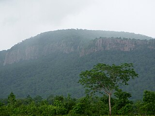
Brahmagiri is an archaeological site located in the Chitradurga district of the state of Karnataka, India. Legend has it that this is the site where sage Gautama Maharishi and his wife Ahalya lived. He was one among seven noted Hindu saints. This site was first explored by Benjamin L. Rice in 1891, who discovered rock edicts of Emperor Ashoka here. These rock edicts indicated that the locality was termed as Isila and denoted the southernmost extent of the Mauryan empire. The Brahmagiri site is a granite outcrop elevated about 180 m. above the surrounding plains and measures around 500 m east-west and 100 m north-south. It is well known for the large number of megalithic monuments that have been found here. The earliest settlement found here has been dated to at least the 2nd millennium BC.

M. R. Seetharam is an Indian politician, entrepreneur, educationist and philanthropist from the state of Karnataka. He was nominated as a member of Legislative Council in 2012. He was the Minister for Planning, Statistics, Science and Technology in the Congress state Government.

Sampaje is a village in the southern state of Karnataka, India. It is located in the Madikeri taluk of Kodagu district in Karnataka. It lies on NH-275 which connects Mangalore city in Dakshina Kannada district with Madikeri town in Kodagu distrtict. It is a border village in between Kodugu and Dakshina kannada.
Kudige is a village in the southern state of Karnataka, India. It is located in the Somvarpet taluk of Kodagu district in Karnataka.
Belakavadi or Belakawadi is a village in the southern state of Karnataka, India. It is located in the Malavalli taluk of Mandya district in Karnataka. As per the records of Hoysala rulers Belakavadi was one of the central places of administrative divisions. Temples include Shanbhulingeshwara Temple, Kashi Vishwanatheshwara Temple and maramma temple.
Agalli is a village in the southern state of Karnataka, India. It is located in the Somvarpet taluk of Kodagu district.

Kombarana Ganapathy Bopaiah is an Indian politician who was also the Speaker of the Karnataka Legislative Assembly. He is a leader of the Bharatiya Janata Party (BJP). He has been appointed pro tem speaker of the Legislative Assembly by the Governor of Karnataka.
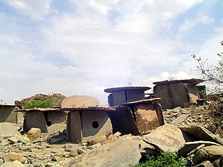
Hirebenakal or Hirébeṇakal or Hirébeṇakallu is a megalithic site in the state of Karnataka, India. It is among the few megalithic sites in India that can be dated to the 800 BCE to 200 BCE period. The site is located in the Koppal district, some 10 kilometres (6.2 mi) west of the town of Gangavati and some 35 kilometres (22 mi) from Hospet city. It contains roughly 400 megalithic funerary monuments, that have been dated to the transition period between Neolithic period and the Iron Age. Known locally as eḷu guḍḍagaḷu, their specific name is moryar guḍḍa. Hirebenakal is reported to be the largest necropolis among the 2000 odd megalithic sites found in South India, most of them in the state of Karnataka. Since 1955, it has been under the management of the Dharwad circle of the Archaeological Survey of India (ASI). On May 19, 2021, it was proposed that Hirebenakal be made a UNESCO World Heritage Site.

Maldare is a small village in Kodagu district of Karnataka state, India.

Attur Nallur is a small village in Somwarpet Taluk in Kodagu District of Karnataka State, India. It comes under Attur Nallur Panchayath. It belongs to Mysore Division. It is located 12 km to the east of District headquarters Madikeri. 28 km from Somvarpet and 234 km from state capital Bangalore.


