Throxenby

Last updated

Throxenby
Suburb
Throxenby Mere - geograph.org.uk - 2764752.jpg
Throxenby Mere
North Yorkshire UK location map (2023).svg
Red pog.svg
Throxenby
Location within North Yorkshire
OS grid reference TA 014890
Civil parish
Unitary authority
Ceremonial county
Region
Country England
Sovereign state United Kingdom
Post town SCARBOROUGH
Postcode district YO12
Police North Yorkshire
Fire North Yorkshire
Ambulance Yorkshire
UK Parliament
List of places
UK
England
Yorkshire
54°17′06″N0°26′31″W / 54.285°N 0.442°W / 54.285; -0.442

Throxenby is a suburb of Scarborough, in North Yorkshire, England. Historically the settlement of Throxenby was a hamlet, separated from Scarborough by countryside.

Contents

History

Throxenby is not mentioned in the Domesday Book, and is first recorded as T'Stanebi in 1167. The name derives from a personal name and means Thorstan's Farm. [1] Throxenby was a township covering a large area in 1859, (some 400 acres (160 ha)), but was also listed as a hamlet 2 miles (3.2 km) north-west of Scarborough. [2] Post the Conquest, the land that formed the eventual Scalby Parish belonged to the crown, but was donated by Henry III to his son Edmund in 1257. However, in 1276, William de Morers gave his land at Throxenby and the manor to Henry de Percy. [3]

Lady Edith's Drive was built to connect the main road at Scalby with Throxenby Mere by the 1st Earl of Londesborough, who named it after his wife. [4] Whilst the Londesborough family were the principal landowners in the area, the lord or lady of the manor is given to those who hold the title of the Duchy of Lancaster, which is the ruling monarch of the time as the estates belong to the crown. [5] It has been suggested by archaeological surveys that the settlement in Medieval times never had an official manor house or church, and that it was populated by tenant farmers, with houses strung out along Throxenby Lane. [6] However, in 1660, Christopher Keld of Newby built a manorial house, which was again replaced. and became known as Throxenby Hall. [7]

c.1831–1832, a military barracks was built in the township, around the same time that Burniston Barracks were built. [8] [9] In 1946, North Riding County Council (later North Yorkshire County Council from 1974), acquired Throxenby Hall and turned it into a home for boys from across the county. The home was closed in 1991, and was later converted into flats. [10]

In 2004, a new St Catherine's Hospice as opened in Throxenby, having previously being located on Scalby Road. [11] [12]

Within the area formerly covered by Throxenby parish, is the deserted Medieval village of Hatterboard (at TA017887). [13]

Governance

Historically, Throxenby and the surrounding area was part of the wapentake of Pickering Lythe. [14]

Population of Throxenby parish 1801–1901
180118111821183118411851186118711881189018911901
48 [15] 58 [15] 66 [15] 54 [15] 71 [15] 57 [15] 45 [15] 130 [15] 128 [15] 202 [16] 225 [15] 253 [15]

In 1831, Throxenby was a township in parish of Scalby, but in 1894, it was partnered with Newby in that civil parish. [17] From 1909, the parish of Newby was subsumed into the neighbouring Scalby Civil Parish. [18] It is now in the Newby and Scalby civil parish, and is represented at Westminster as part of the Scarborough and Whitby Constituency. [19]

Throxenby Mere

Throxenby Mere is a body of water to the west of the village immediately below Raincliff Woods and Irton Moor. Early maps do not show a body of water, though the ground being a natural hollow, it is thought to have been quite marshy and prone to flooding. [20] The mere was dammed in the 19th century, and the outflow now runs along the southern edge of Lady Edith's Drive in the area. [21] The mere is designated as a mesotrophic lake, and covers an area of 4.3 acres (1.76 ha). [22] Wildlife observed on the mere includes mallards, tufted ducks and smews. [23]

Related Research Articles

<span class="mw-page-title-main">Borough of Scarborough</span> Former local government district in England

The Borough of Scarborough was a non-metropolitan district with borough status in North Yorkshire, England. In addition to the town of Scarborough, it covered a large stretch of the coast of Yorkshire, including Whitby and Filey. It bordered Redcar and Cleveland to the north, the Ryedale and Hambleton districts to the west and the East Riding of Yorkshire to the south.

<span class="mw-page-title-main">Tadcaster</span> Town in North Yorkshire, England

Tadcaster is a market town and civil parish in North Yorkshire, England, 12 miles (19 km) north-east of Leeds and 10 miles (16 km) south-west of York. Its historical importance from Roman times onward was largely as the lowest road crossing-point on the River Wharfe until the construction of the A64 Tadcaster by-pass some 660 yards (600 m) to the south, in 1978. There are two rail crossings downstream of the town before the Wharfe joins the River Ouse near Cawood.

<span class="mw-page-title-main">Austwick</span> Village and civil parish in North Yorkshire, England

Austwick is a village and civil parish in the Craven district of North Yorkshire, England, about 5 miles (8 km) north-west of Settle. The village is on the edge of the Yorkshire Dales National Park.

<span class="mw-page-title-main">Scalby, North Yorkshire</span> Village in North Yorkshire, England

Scalby, a village on the north edge of Scarborough, North Yorkshire, England, is part of the civil parish of Newby and Scalby. From 1902 to 1974, Scalby was an urban district in the North Riding of Yorkshire.

<span class="mw-page-title-main">High Worsall</span> Hamlet and civil parish in North Yorkshire, England

High Worsall is a hamlet and civil parish in North Yorkshire, England. It is near Low Worsall and 4 miles (6.4 km) west of Yarm. The population of the parish was estimated at 40 in 2010. The population remained at less than 100 at the 2011 Census, so details were included in the civil parish of Low Worsall. However, in 2015, North Yorkshire County Council estimated the hamlet to have 40 people living there in 2015.

<span class="mw-page-title-main">Scalby, East Riding of Yorkshire</span> Hamlet in the East Riding of Yorkshire, England

Scalby is a hamlet in the East Riding of Yorkshire, England. It is situated approximately 7 miles (11 km) west of Brough and 7 miles (11 km) north-east of Goole. It lies on the B1230 road.

<span class="mw-page-title-main">William Denison, 1st Earl of Londesborough</span> British peer and Liberal politician

William Henry Forester Denison, 1st Earl of Londesborough, known as The Lord Londesborough from 1860 to 1887, was a British peer and Liberal politician. He was also one of the main founders of Scarborough FC.

<span class="mw-page-title-main">Flixton, North Yorkshire</span> Village in North Yorkshire, England

Flixton is a village in North Yorkshire, England. Until 1974 the village lay in the historic county boundaries of the East Riding of Yorkshire and from 1974 to 2023 it was part of the Borough of Scarborough. There is a public house, the Foxhound Inn.

<span class="mw-page-title-main">Sea Cut (Scalby Beck)</span> River in North Yorkshire, England

The Sea Cut (Scalby Beck) is a small river that enters the North Sea at Scalby Mills, Scarborough, North Yorkshire, England. The beck is fed from local streams in Scalby, Newby and Burniston and other watercourses draining off the nearby hills. It is also a bypass channel for the upper reaches of the River Derwent when it is under flood conditions.

<span class="mw-page-title-main">Church of St Oswald, Filey</span> Anglican church in Filey, North Yorkshire, England

The Church of St Oswald, Filey, is a parish church in the North Yorkshire town of Filey, England. The church dates from the 12th and 13th centuries, with some embattlements added in the 15th century. The building is now grade I listed and was described by Pevsner as "easily the finest church in the north-east corner of the East Riding".

<span class="mw-page-title-main">St Germain's Churchyard</span> Cemetery in Yorkshire, England

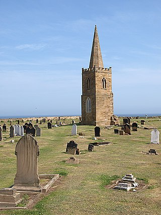
St Germain's Churchyard is a large cemetery overlooking the North Sea at Marske-by-the-Sea, North Yorkshire, England. Its church tower is a grade II listed structure at the midpoint to the yard and a landmark for sailors out on the sea. It is a remnant of a demolished church, services at St Germain's were replaced in 1876 by St Mark's.

<span class="mw-page-title-main">Church of All Saints, Skipsea</span> Anglican church in the East Riding of Yorkshire, England

The Church of All Saints, is the church for the village and parish of Skipsea, in the East Riding of Yorkshire, England. The church dates back to the late 11th/early 12th century and was the religious house tied to Skipsea Castle, which lay just to the west in Skipsea Brough. A causeway, to the north of the church, used to link it with the castle motte across what was Skipsea Bail Mere. The village continued developing long after the castle had been demolished c. 1221, and the church became the house of worship for Skipsea.

<span class="mw-page-title-main">Ulshaw Bridge</span> A hamlet in North Yorkshire, England

Ulshaw Bridge is a hamlet on the River Ure, near to Middleham, in North Yorkshire, England. The hamlet derives its name partly from the Medieval stone bridge which spans the River Ure to the immediate south of the hamlet. Ulshaw Bridge is 2.5 miles (4 km) west of Thornton Steward, and 1.25 miles (2 km) east of Middleham.

<span class="mw-page-title-main">Thirsk Castle</span> Former castle building in North Yorkshire, England

Thirsk Castle was a defensive Medieval castle in the town of Thirsk, in North Yorkshire, England. The castle was one of three held by the de Mowbray family in Yorkshire.

<span class="mw-page-title-main">Snape Castle</span> Listed building in North Yorkshire, England

Snape Castle is a semi-fortified manor house in the village of Snape, North Yorkshire, England. The castle is 3 miles (5 km) south of Bedale and 19 miles (31 km) north of Ripon. At the time of Henry VIII, John Leland described it as "...a goodly castel in a valley [be]longing to the Lorde Latimer.." The castle is now a private residence, and is a grade I listed building.

<span class="mw-page-title-main">Marton cum Grafton</span> Civil parish in North Yorkshire, England

Marton cum Grafton is a civil parish in the Borough of Harrogate of North Yorkshire, England. The parish has only two settlements, and has a magnesian limestone and sandstone geography, which has been used for quarrying. The landform is broadly flat, though there are some small hills with the Marton and Grafton being separated by 98 feet (30 m) despite being only 0.5 miles (0.8 km) apart.

<span class="mw-page-title-main">Raw, North Yorkshire</span> Hamlet in North Yorkshire, England

Raw is a hamlet in the Borough of Scarborough of North Yorkshire, England, near to the villages of Fylingthorpe, Robin Hood's Bay, and Hawsker. The hamlet is mostly agricultural in nature and it lies 0.5-mile (0.8 km) north-west of Fylingthorpe, 4.5 miles (7.2 km) south-east of Whitby, and due east of the A171 road.

<span class="mw-page-title-main">Henderskelfe</span> Civil parish in North Yorkshire, England

Henderskelfe is a civil parish in North Yorkshire, England. The parish does not contain any villages, though it is named after a previous settlement and castle which occupied the land on which Castle Howard is now built. Historically the area was a township in the ecclesiastical parish of Bulmer, however it has been its own civil parish since 1866.

<span class="mw-page-title-main">Falsgrave</span> Suburb of Scarborough, North Yorkshire, England

Falsgrave is a suburb of Scarborough in North Yorkshire, England. Historically, the settlement of Falsgrave pre-dated the Domesday Book survey and was also the manor in the area, existing as the main administrative seat in the region long before the town of Scarborough developed. Gradually the settlement of Falsgrave became a suburb of Scarborough, and lies a little to the west of the town centre at the junction of the A64, A170 and A171 roads. Parts of the suburb were designated as a conservation area in 1985.

<span class="mw-page-title-main">Saxton with Scarthingwell</span> Civil parish in North Yorkshire, England

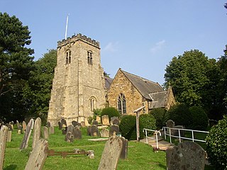
Saxton with Scarthingwell is a civil parish just south of Tadcaster in North Yorkshire, England. The parish contains the villages of Saxton and Scarthingwell, with two churches and the remains of a castle. Historically the area was a township, however it has been its own civil parish since 1866. Although the main part of the Battle of Towton was fought to the north out of the parish, some of the dead were interred in the parish, and at least one minor skirmish was fought within the parish boundaries.

References

  1. Smith, A. H. (1979) [1928]. The Place Names of the North Riding of Yorkshire. English Place Name Society. p. 110. OCLC   19714705.
  2. Whellan, T (1859). History and Topography of the City of York and the North Riding of Yorkshire. Beverley: Whellan. p. 918. OCLC   504050072.
  3. Dennison 2002, p. 7.
  4. Pearson, Trevor (2018). "An Archaeological Survey of Forge Valley, Raincliffe and Row Brow Woods Scarborough North Yorkshire" (PDF). sahs.org.uk. p. 33. Retrieved 8 January 2023.
  5. Kelly's Directory of N & E Ridings of Yorkshire, 1893. [Part 1: Places]. London: Kelly & Co. 1893. p. 255. OCLC   1131686665.
  6. Dennison 2002, p. 8.
  7. "Genuki: SCALBY: Geographical and Historical information from the year 1890., Yorkshire (North Riding)". www.genuki.org.uk. Retrieved 10 March 2023.
  8. Page 1968, p. 478.
  9. "Military Command and Control Organisation Volume 5 Appendices". historicengland.org.uk. p. 77. Retrieved 10 March 2023.
  10. Gavaghan, Carl (2 July 2015). "Three held over '30 years of abuse' at Scarborough boys' home". The Yorkshire Post. Retrieved 9 January 2023.
  11. "Work starts on hospice replacement". The Northern Echo. 14 January 2003. p. 6. ISSN   2043-0442.
  12. "Hospice chief stepping down" . infoweb.newsbank.com. 16 October 2004. Retrieved 9 January 2023.
  13. Beresford, Maurice; Hurst, John G., eds. (1971). Deserted medieval villages: studies;. London: Lutterworth Press. p. 210. ISBN   0718813731.
  14. Parliamentary Papers Poor Law Unions volume 49, part II. London: HMSO. 1862. p. 549. OCLC   145367615.
  15. 1 2 3 4 5 6 7 8 9 10 11 Page, William, ed. (1907). The Victoria history of the county of York. vol 3. London: Constable & Co. p. 520. OCLC   500092527.
  16. "Genuki: SCALBY: Geographical and Historical information from the year 1890., Yorkshire (North Riding)". www.genuki.org.uk. Retrieved 9 January 2023.
  17. Page 1968, pp. 476–477.
  18. "Throxenby Tn/CP". visionofbritain.org.uk. Retrieved 9 January 2023.
  19. "Election Maps". www.ordnancesurvey.co.uk. Retrieved 10 March 2023.
  20. Pearson, Trevor (2018). "An Archaeological Survey of Forge Valley, Raincliffe and Row Brow Woods Scarborough North Yorkshire" (PDF). sahs.org.uk. p. 31. Retrieved 8 January 2023.
  21. Rimington 1961, p. 7.
  22. "Scarborough Biodiversity Action Plan" (PDF). scarborough.gov.uk. p. 42. Retrieved 9 January 2023.
  23. Robinson, Maureen (1 February 2018). "Rare visitor is spotted at Throxenby". The Scarborough News. No. 05–2018. p. 41. ISSN   0250-5150.

Sources