
Brierfield is a town and civil parish in the Borough of Pendle, in Lancashire, England. It is 2.5 miles (4.0 km) north east of Burnley, 1 mile (1.6 km) south west of Nelson, and 0.5 miles (0.8 km) north east of Reedley. The parish had a population of 8,193, at the census of 2011.

General Sir James Yorke Scarlett was a British Army officer and hero of the Crimean War who led the Charge of the Heavy Brigade during the Battle of Balaclava on 25 October 1854.
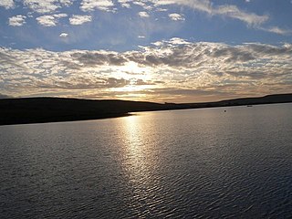
Dunnockshaw or Dunnockshaw and Clowbridge is a civil parish in the borough of Burnley, in Lancashire, England. The parish is situated between Burnley and Rawtenstall. According to the United Kingdom Census 2011, the parish has a population of 185.
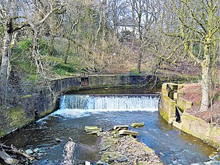
The River Brun is a river in eastern Lancashire. It is approximately 4.5 miles (7.2 km) long and has a catchment area of 9.32 square miles (24.134 km2).

Cliviger is a civil parish in the Borough of Burnley, in Lancashire, England. It is situated to the southeast of Burnley, and northwest of Todmorden. According to the 2011 census, the parish has a population of 2,238.
Huncoat is a village in Lancashire, England; situated in the North West. It is located to the east of Accrington. It is a ward of Hyndburn where the population taken at the 2011 census was 4,418.

Huntroyde Hall is a grade II listed, 16th-century house in the civil parish of Simonstone in the Borough of Ribble Valley, Lancashire, England. Its estate, Huntroyde Demesne, once extended to over 6,500 acres.

The Lancashire Coalfield in North West England was an important British coalfield. Its coal seams were formed from the vegetation of tropical swampy forests in the Carboniferous period over 300 million years ago.
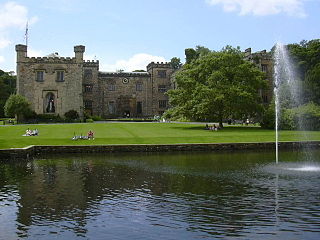
The Towneley or Townley family are an English (UK) family whose ancestry can be traced back to Anglo-Saxon England. Towneley Hall in Burnley, Lancashire, was the family seat until its sale, together with the surrounding park, to the corporation of Burnley in 1901. Towneley Hall is now a Grade I listed building and a large museum and art gallery within Towneley Park (UK).

Hameldon Hill is a Carboniferous sandstone hill with a summit elevation of 409 metres (1,342 ft), situated between the towns of Burnley and Accrington in Lancashire, England. It is listed as a "HuMP" or "Hundred Metre Prominence", its parent being Freeholds Top, a Marilyn near Bacup.

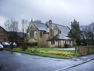
The Church of St John the Divine is in Burnley Road, Holme Chapel, a village in the civil parish of Cliviger, near Burnley, Lancashire, England. It is an active Anglican parish church in the diocese of Blackburn, and the church is recorded in the National Heritage List for England as a designated Grade II listed building. It was built between 1788 and 1794, replacing a small chapel, and is in simple Classical style. Above the west front is a bell turret with an octagonal cupola, and inside the church are carved oak stalls, moved from a demolished church, which include a poppyhead and misericords.

The Hulton family of Hulton lived and owned land in Lancashire for more than eight hundred years from the late-12th to the late-20th centuries. The family took its name from the three townships surrounding their Hulton Park Estate, Over, Middle and Little Hulton.

The Burnley Coalfield is the most northerly portion of the Lancashire Coalfield. Surrounding Burnley, Nelson, Blackburn and Accrington, it is separated from the larger southern part by an area of Millstone Grit that forms the Rossendale anticline. Occupying a syncline, it stretches from Blackburn past Colne to the Yorkshire border where its eastern flank is the Pennine anticline.

Bank Hall Colliery was a coal mine on the Burnley Coalfield in Burnley, Lancashire near the Leeds and Liverpool Canal. Sunk in the late 1860s, it was the town's largest and deepest pit and had a life of more than 100 years.
Hapton Valley Colliery was a coal mine on the edge of Hapton near Burnley in Lancashire, England. Its first shafts were sunk in the early 1850s and it had a life of almost 130 years, surviving to be the last deep mine operating on the Burnley Coalfield.

The Burnley Embankment is an embankment carrying the Leeds and Liverpool Canal across the Calder and Brun valleys in Burnley, Lancashire. Also known as the Straight Mile, the embankment is 1,256 yards long and the canal runs up to 60 feet (18 m) above the valley floor. The structure was chosen as one of the original Seven Wonders of the Waterways, and has been awarded a Red Wheel by the Transport Trust.

Queens Park is a public park in Burnley, Lancashire. It covers 11.2 hectares and was opened in 1893, making it Burnley's oldest park.

Thompson Park is a formal Edwardian park in Burnley, Lancashire. It was opened to the public in 1930.
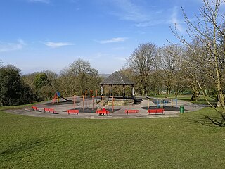
Scott Park is a public park in Burnley, Lancashire. It covers 7.9 hectares and was opened in 1895. Located south of the town centre, attractions include tennis courts, a children's play area, a bandstand, and bowling greens.

Colonel Sir John Hardy Thursby, 1st Baronet was a British landowner, military officer, and sportsman.
 Sir John Hardy Thursby, 1st Baronet (1826–1901)
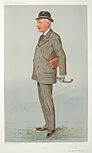 Caricature of Sir John Ormerod Scarlett Thursby, 2nd Baronet (1861–1920), published in Vanity Fair , 28 August 1907
 Caricature of Sir George James Thursby, 3rd Baronet (1869–1941)

