Tier-scalable reconnaissance is the term for an approach to deploying and controlling vehicles in multiple areas of interest, such as in the exploration of planets or diverse regions on Earth. It is not a rigid or fixed paradigm, but is infinitely extensible. It uses hierarchical levels of oversight called tiers, each tier commanding or controlling the vehicles within the tier beneath it. The size of each tier can be scaled from one to many vehicles.
Robotic planetary exploration missions typically use a single lander or rover. This is by design, driven primarily by safety and engineering constraints, at the expense of mission reliability and science return. Rovers are generally capable mobile platforms, but they are incapable of exploring multiple distant sites on a planetary surface. They are usually not used to explore potentially hazardous, scientifically interesting regions. At the other extreme, orbiting satellites have the benefit of a global perspective, but miss much surface detailed information. In either case, using a rover or orbiter, monitoring changing events on the surface is difficult, if not altogether impossible.
Tier-scalable reconnaissance, on the other hand, distributes the burden of data gathering across different logical tiers. In this way, a mission is more distributed, goal-driven, and less constrained. And, because of the numerous vehicles in each tier, a mission is more survivable and more capable. Consider the following scenario: The vehicles in the spaceborne and airborne tiers have overhead perspectives at different scales and resolutions. They map out areas of interest and acquire terrain data, and then choose targets for visiting and sampling by the ground vehicles. The overhead perspective also allows the higher tiers to determine paths for safe passage of these vehicles to their targets. The ground-tier vehicles gather local data that complement the remote sensing data obtained by the spaceborne and airborne vehicles.
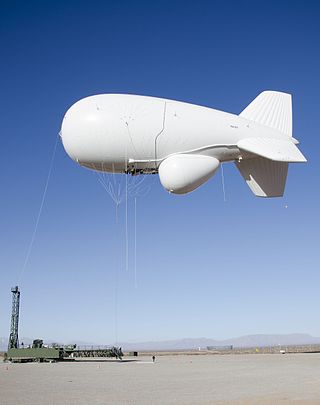
In addition to the spaceborne and ground tiers, there may be several airborne tiers having vehicles such as balloons, blimps, and unmanned aerial vehicles (UAVs) at different altitudes. The tier-scalable reconnaissance paradigm is not limited to space, aerial, and ground applications but can be applied as well to water, subterranean, and ocean floor scenarios for scientific, commercial, or military purposes.
The tier-scalable reconnaissance paradigm is also highly automated. Spaceborne orbiters command and control the airborne vehicles autonomously, and the airborne vehicles in turn command and control the ground-tier reconnaissance vehicles. This allows orbiters, airships, and rovers to act in a unified, controlled manner. A mission that uses this paradigm is also considered more survivable. Since the airborne and ground-tier vehicles can be quite inexpensive, even expendable, many such vehicles can be used collectively to explore numerous science targets with complementary suites of instruments. Even if one or more vehicles should fail, others are present to take up the slack and continue the mission.
Scenarios
Tier-scalable reconnaissance missions allow access to targets of great interest on planetary bodies, something which is not currently feasible with conventional single-rover or single-orbiter mission designs. Tier-scalable reconnaissance missions also enable spanning larger surface areas than previously possible – mimicking the way geologists explore regions on Earth – and therefore allow for greater data return.
Consider how the tier-scalable paradigm adapts to various environmental scenarios:
Environments with atmospheres and with non-extreme surface temperatures (Earth, Mars):
Tier 1: Spaceborne orbiters, which guide deployment and control of
Tier 2: Airborne balloons or blimps, which in turn deploy and control
Tier 3: Surface-based buoys, and sensors, which in turn deploy and control
Environments with atmospheres and with extreme surface temperatures (Venus, Titan):[2]
Tier 1: Spaceborne orbiters, which guide deployment and control of
Tier 2: Airborne balloons or blimps, which, if conditions permit, deploy and control
Tier 3: Ground sensor webs, rovers, or submersibles.
Environments without atmospheres and with extreme surface conditions (Mercury, Moon, Europa):
Tier 1: Spaceborne orbiters, which guide deployment of and communicate with
Tier 2: Ground-based rovers and sensor webs.
Commanding and operation
Using traditional means, simultaneous commanding of even a few reconnaissance vehicles becomes exceedingly complex, and so the logistical and computational demands of the tier-scalable paradigm scale quickly beyond the computers able to fit on such vehicles. This problem is overcome by using a round-robin concurrent commanding scheme.[3] In this scheme, the vehicles are not commanded simultaneously; instead, each is commanded in turn, one by one. Moreover, each vehicle is given a small command set to execute. In this way, one vehicle is being commanded while the others are executing their issued commands. Depending on how close the vehicles are to each other and how accurately they execute their navigation commands, an airborne deployment reassessment is done so that refined trajectories are computed for each vehicle. Thus, each vehicle can be commanded in turn without threat of collision.
In the tier-scalable paradigm, ground-tier vehicles are commanded typically through the use of local airborne vehicles, such as blimps or balloons. The airborne vehicles contain onboard tracking and command systems for use with the ground-tier vehicles. With a wide field of view, the tracking and commanding systems on board the airborne vehicles determine optimal paths for the ground-tier vehicles, identifying both obstacles and interesting science targets. The ground-tier vehicles are then commanded to navigate through the operational area to the designated targets, while avoiding the identified obstacles. Therefore, this approach does not rely on the limited horizontal view of the ground-tier vehicles. Each ground-tier vehicle includes its own instrument suite to collect information, which is transmitted back to the airborne tier.
The ground-tier vehicles may conduct measurements en route to their targets. If an interesting object is encountered along the way, a vehicle may request permission of the commanding tier to explore it. A ground-tier vehicle may also find itself in an area of geography through which it cannot pass. In this case, it would request an alternate trajectory to its target, or even a target reassignment. These resolutions are possible because the higher-level airborne commanding tier is able to reassess the deployment of the vehicles, refining the trajectories of each of the vehicles at each step. In this way, even if a vehicle should go off-course, such as from sliding on sandy soil, the commanding tier will recalculate a path to the target based on the vehicle's current position.
Applications
Robotic reconnaissance operations are called for in extreme environments such as space, as well as in potentially hazardous or inaccessible operational areas on Earth, such as those related to military or terrorist activities, or areas that have been exposed to biochemical agents, radiation, or natural disasters.
Tier-scalable reconnaissance opens access to geologic sites not currently feasible to visit, such as canyons, mountain ranges, chaotic and rugged terrain, impact basins and craters, even volcanoes and liquid pools or lakes. In addition, other exotic locales of scientific interest exist on the planetary bodies of the Solar System that are particularly crucial in the search for extraterrestrial biological activity in general, and sample return missions in particular.
Some of the major advantages of tier-scalable reconnaissance architectures include:
Overhead navigation, enabling deployment of simple, inexpensive, expendable ground vehicles;
Efficient commanding of multiple ground vehicles;
Mission safety, reliability, and survivability;
Optimized target identification, path planning, and obstacle avoidance; and
Real time reconnaissance, allowing identification and characterization of active events.
Also, tier-scalable reconnaissance reduces driving requirements for ground vehicles, since they already are deployed in the vicinity of where they need to be. Therefore, driving is limited to “fine-tuning” the location of the ground-tier vehicles to perform local sampling, as opposed to “long-distance” driving towards the location where they need to be. Hence, inexpensive, expendable miniaturized vehicles with limited driving capabilities can be used.
The ground-tier vehicles have limited onboard computing capabilities, since they off-load data analysis to a primary lander or higher tiers that have higher-grade computing equipment. Conceptually, a primary lander is a higher-grade computing engine that also acts as a communication relay, much like a planetary internet router between the tiers. Thus, the tier-scalable reconnaissance paradigm, by its inherent architecture, is an extended distributed computing topology unto itself.
Developments
Individual components of the tier-scalable reconnaissance paradigm are either under development or have already been tested and proven “in the field.” These include orbiters, balloons, blimps, airships, and ground-based vehicles such as rovers and landers as well as sensor webs. The biggest challenge, however, appears to be not so much the hardware but the “intelligent” software that would enable all the components of a tier scalable mission to be integrated and function autonomously.[4]
Related Research Articles
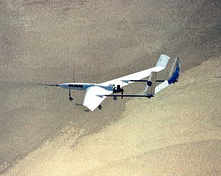
An aerobot is an aerial robot, usually used in the context of an unmanned space probe or unmanned aerial vehicle.
A military aircraft is any fixed-wing or rotary-wing aircraft that is operated by a legal or insurrectionary military of any type. Military aircraft can be either combat or non-combat:
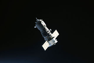
Uncrewed spacecraft or robotic spacecraft are spacecraft without people on board. Uncrewed spacecraft may have varying levels of autonomy from human input; they may be remote controlled, remote guided or autonomous: they have a pre-programmed list of operations, which they will execute unless otherwise instructed. A robotic spacecraft for scientific measurements is often called a space probe or space observatory.
Aerial warfare is the use of military aircraft and other flying machines in warfare. Aerial warfare includes bombers attacking enemy installations or a concentration of enemy troops or strategic targets; fighter aircraft battling for control of airspace; attack aircraft engaging in close air support against ground targets; naval aviation flying against sea and nearby land targets; gliders, helicopters and other aircraft to carry airborne forces such as paratroopers; aerial refueling tankers to extend operation time or range; and military transport aircraft to move cargo and personnel.
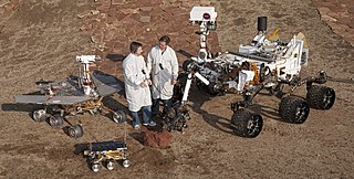
Mars Science Laboratory (MSL) is a robotic space probe mission to Mars launched by NASA on November 26, 2011, which successfully landed Curiosity, a Mars rover, in Gale Crater on August 6, 2012. The overall objectives include investigating Mars' habitability, studying its climate and geology, and collecting data for a human mission to Mars. The rover carries a variety of scientific instruments designed by an international team.
Space-based radar or spaceborne radar is a radar operating in outer space; orbiting radar is a radar in orbit and Earth orbiting radar is a radar in geocentric orbit. A number of Earth-observing satellites, such as RADARSAT, have employed synthetic aperture radar (SAR) to obtain terrain and land-cover information about the Earth.
Aerocapture is an orbital transfer maneuver in which a spacecraft uses aerodynamic drag force from a single pass through a planetary atmosphere to decelerate and achieve orbit insertion.
ILC Dover, LP is a special engineering development and manufacturing company, globally headquartered in Frederica, Delaware. ILC Dover specializes in the use of high-performance flexible materials, serving the aerospace, personal protection, and pharmaceutical industries.
The Lockheed DC-130 is a variant of the C-130 Hercules modified for drone control. It can carry four Ryan Firebee drones underneath its wings.
A rover is a planetary surface exploration device designed to move over the rough surface of a planet or other planetary mass celestial bodies. Some rovers have been designed as land vehicles to transport members of a human spaceflight crew; others have been partially or fully autonomous robots. Rovers are typically created to land on another planet via a lander-style spacecraft, tasked to collect information about the terrain, and to take crust samples such as dust, soil, rocks, and even liquids. They are essential tools in space exploration.
Northern Light was a concept mission for a robotic mission to Mars that would consist of a lander and a rover, being studied by a consortium of Canadian universities, companies and organisations. The primary contractor for the spacecraft was Thoth Technology Inc.
TriDAR, or Triangulation and LIDAR Automated Rendezvous and Docking, is a relative navigation vision system developed by Neptec Design Group and funded by the Canadian Space Agency and NASA. It provides guidance information that can be used to guide an unmanned vehicle during rendezvous and docking operations in space. TriDAR does not rely on any reference markers positioned on the target spacecraft. Instead, TriDAR relies on a laser based 3D sensor and a thermal imager. TriDAR's proprietary software uses the geometric information contained in successive 3D images to match against the known shape of the target object and calculate its position and orientation.
K10 are rovers used to explore planetary surfaces. Each third-generation K10 has four-wheel drive, all-wheel steering and a passive averaging suspension. This helps reduce the motion induced by travel over uneven ground. The K10 has mounting points on its front, back, and bottom that allows for antennas, sensors, and other scientific instruments to be attached. The K10 controller runs on a Linux laptop and communicates via 802.11g wireless, or a Tropos mesh wireless.
A Mars aircraft is a vehicle capable of sustaining powered flight in the atmosphere of Mars. So far, the Mars helicopter Ingenuity is the only aircraft ever to fly on Mars, completing 67 successful flights covering 15.499 km (9.631 mi) in 2 hour, 1 minutes and 4 seconds of flight time.
MELOS is a Japanese rover mission concept under study for an engineering demonstration of precision landing, and to look for possible biosignatures on Mars using a rover. JAXA has not published updates since 2015.
The Joint Land Attack Cruise Missile Defense Elevated Netted Sensor System, or JLENS, was a tethered aerial detection system designed to track boats, ground vehicles, cruise missiles, manned and unmanned aircraft, and other threats. The system had four primary components: two tethered aerostats which utilized a helium/air mix, armored mooring stations, sophisticated radars, and a processing station designed to communicate with anti-missile and other ground and airborne systems. Each system was referred to as an "orbit", and two orbits were built. The Army-led joint program which fielded JLENS was designed to complement fixed-wing surveillance aircraft, saving money on crew, fuel, maintenance and other costs, and give military commanders advance warning to make decisions and provide notifications. Following cost overruns, underperformance, declining support in Congress, and public scrutiny following a snapped tether which allowed one craft moored at Aberdeen Proving Ground, Maryland to drift on a 100-mile uncontrolled descent across Pennsylvania, dragging its cable tether which damaged power lines and cut power to 20,000 homes, the program was suspended in October 2015, and completely discontinued by 2017.
Schiaparelli EDM was a failed Entry, Descent, and Landing Demonstrator Module (EDM) of the ExoMars programme—a joint mission of the European Space Agency (ESA) and the Russian Space Agency Roscosmos. It was built in Italy and was intended to test technology for future soft landings on the surface of Mars. It also had a limited but focused science payload that would have measured atmospheric electricity on Mars and local meteorological conditions.
Tianwen-1 Chinese: 天问一号 is an interplanetary mission by the China National Space Administration (CNSA) which sent a robotic spacecraft to Mars, consisting of 6 spacecraft: an orbiter, two deployable cameras, lander, remote camera, and the Zhurong rover. The spacecraft, with a total mass of nearly five tons, is one of the heaviest probes launched to Mars and carries 14 scientific instruments. It is the first in a series of planned missions undertaken by CNSA as part of its Planetary Exploration of China program.
The Planetary Exploration of China, also known as Tianwen, is the robotic interplanetary spaceflight program conducted by the China National Space Administration (CNSA). The program aims to explore planets of the Solar System, starting from Mars, and will be expanded to Jupiter and more in the future.
References
↑ Fink W, Dohm JM, Tarbell MA, Hare TM, Baker VR (2005) Next-Generation Robotic Planetary Reconnaissance Missions: A Paradigm Shift; Planetary and Space Science, 53, 1419–1426
↑ Noor AK, Cutts JA, Balint TS (2007) Platforms for discovery: Exploring Titan and Venus; Aerospace America/June 2007
↑ Fink W, Tarbell MA, Jobling FM (2008) Tier-Scalable Reconnaissance – A Paradigm Shift in Autonomous Remote Planetary Exploration of Mars and Beyond. Chapter 1 in “Planet Mars Research Focus”, Ed. F. Columbus. Nova Science Publishers, Hauppauge, NY. (in press)
↑ Popular Science Magazine, March 2006 issue: Exploring Mars with Blimps and Cliff-scaling Robots
This page is based on this Wikipedia article Text is available under the CC BY-SA 4.0 license; additional terms may apply. Images, videos and audio are available under their respective licenses.