
North America is a continent in the Northern and Western Hemispheres. North America is bordered to the north by the Arctic Ocean, to the east by the Atlantic Ocean, to the southeast by South America and the Caribbean Sea, and to the west and south by the Pacific Ocean. Greater North America includes the Bahamas, Bermuda, Canada, the Caribbean, Central America, Clipperton Island, Greenland, Mexico, Saint Pierre and Miquelon, Turks and Caicos Islands, and the United States.

North Carolina is a state in the Southeastern region of the United States. It is bordered by Virginia to the north, the Atlantic Ocean to the east, South Carolina to the south, Georgia to the southwest, and Tennessee to the west. The state is the 28th-largest and 9th-most populous of the United States. Along with South Carolina, it makes up the Carolinas region of the East Coast. At the 2020 census, the state had a population of 10,439,388. Raleigh is the state's capital and Charlotte is its most populous city. The Charlotte metropolitan area, with an estimated population of 2,805,115 in 2023, is the most populous metropolitan area in North Carolina, the 22nd-most populous in the United States, and the largest banking center in the nation after New York City. The Research Triangle, with an estimated population of 2,368,947 in 2023, is the second-most populous combined metropolitan area in the state, 31st-most populous in the United States, and is home to the largest research park in the United States, Research Triangle Park.

North Rhine-Westphalia or North-Rhine/Westphalia, commonly shortened to NRW, is a state (Land) in Western Germany. With more than 18 million inhabitants, it is the most populous state in Germany. Apart from the city-states, it is also the most densely populated state in Germany. Covering an area of 34,084 square kilometres (13,160 sq mi), it is the fourth-largest German state by size.

The Cree are a North American Indigenous people. They live primarily in Canada, where they form one of the country's largest First Nations.

Charlotte is the most populous city in the U.S. state of North Carolina and the county seat of Mecklenburg County. The population was 874,579 at the 2020 census, making Charlotte the 15th-most populous city in the United States, the seventh-most populous city in the South, and the second-most populous city in the Southeast behind Jacksonville, Florida. The city is the cultural, economic, and transportation center of the Charlotte metropolitan area, whose estimated 2023 population of 2,805,115 ranked 22nd in the United States. The Charlotte metropolitan area is part of an eighteen-county market region or combined statistical area with an estimated 2023 population of 3,387,115.

Raleigh is the capital city of the U.S. state of North Carolina and the seat of Wake County. It is the second-most populous city in North Carolina, after Charlotte. Raleigh is the tenth-most populous city in the Southeast, the 41st-most populous city in the U.S., and the largest city of the Research Triangle metro area. Raleigh is known as the "City of Oaks" for its many oak trees, which line the streets in the heart of the city. The city covers a land area of 148.54 square miles (384.7 km2). The U.S. Census Bureau counted the city's population as 467,665 at the 2020 census. It is one of the fastest-growing cities in the United States. The city of Raleigh is named after Sir Walter Raleigh, who established the now-lost Roanoke Colony in present-day Dare County.

Wake County is located in the U.S. state of North Carolina. As of the 2020 census, its population was 1,129,410, making it North Carolina's most populous county. From July 2005 to July 2006, Wake County was the 9th-fastest growing county in the United States, with Cary and Raleigh being the 8th- and 15th-fastest growing communities, respectively.
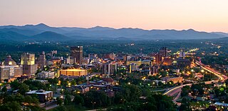
Asheville is a city in and the county seat of Buncombe County, North Carolina, United States. Located at the confluence of the French Broad and Swannanoa rivers, it is the most populous city in Western North Carolina, and the state's 11th-most-populous city. According to the 2020 census, the city's population was 94,589, up from 83,393 in the 2010 census. It is the principal city in the three-county Asheville metropolitan area, which had an estimated population of 417,202 in 2023.

A capital city or just capital is the municipality holding primary status in a country, state, province, department, or other subnational division, usually as its seat of the government. A capital is typically a city that physically encompasses the government's offices and meeting places; the status as capital is often designated by its law or constitution. In some jurisdictions, including several countries, different branches of government are in different settlements, sometimes meaning multiple official capitals. In some cases, a distinction is made between the official (constitutional) capital and the seat of government, which is in another place.

Brisbane is the capital of the state of Queensland and the third-most populous city in Australia and Oceania, with a population of approximately 2.6 million. Brisbane lies at the centre of South East Queensland, which includes several other regional centres and cities. The central business district is situated within a peninsula of the Brisbane River about 15 km (9 mi) from its mouth at Moreton Bay. Brisbane is located in the hilly floodplain of the Brisbane River Valley between Moreton Bay and the Taylor and D'Aguilar mountain ranges. It sprawls across several local government areas, most centrally the City of Brisbane. The demonym of Brisbane is Brisbanite.

Cairns is a city in Queensland, Australia, on the tropical north east coast of Far North Queensland. In the 2021 census, Cairns had a population of 153,181 people.

The Piedmont is a plateau region located in the Eastern United States. It is situated between the Atlantic Plain and the Blue Ridge Mountains, stretching from New York in the north to central Alabama in the south. The Piedmont Province is a physiographic province of the larger Appalachian Highlands physiographic division and consists of the Piedmont Upland, and the Piedmont Lowlands sections.
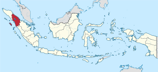
North Sumatra is a province of Indonesia located in the northern part of the island of Sumatra. Its capital and largest city is Medan. It is bordered by Aceh on the northwest and Riau and West Sumatra on the southeast, with two different coastlines located on the Indian Ocean and the Strait of Malacca, and a maritime border with Malaysia to the east. North Sumatra is Indonesia's fourth most populous province after West Java, East Java, and Central Java, and is also the most populous province outside of Java Island. North Sumatra is also the third-largest province in area on the island of Sumatra after South Sumatra and Riau provinces. It covers an area of 72,460.74 km2, which is approximately the same size as Sierra Leone or Scotland or Maine.

The Blue Ridge Mountains are a physiographic province of the larger Appalachian Highlands range. The mountain range is located in the Eastern United States and extends 550 miles southwest from southern Pennsylvania through Maryland, West Virginia, Virginia, North Carolina, South Carolina, Tennessee, and Georgia. The province consists of northern and southern physiographic regions, which divide near the Roanoke River gap. To the west of the Blue Ridge, between it and the bulk of the Appalachians, lies the Great Appalachian Valley, bordered on the west by the Ridge and Valley province of the Appalachian range.
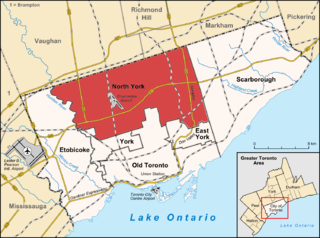
North York is a former township and city and is now one of the six administrative districts of Toronto, Ontario, Canada. It is located in the northern area of Toronto, centred around Yonge Street, north of Ontario Highway 401. It is bounded by York Region to the north at Steeles Avenue, on the west by the Humber River, on the east by Victoria Park Avenue. Its southern boundary is erratic and corresponds to the northern boundaries of the former municipalities of Toronto: York, Old Toronto and East York. As of the 2016 Census, the district has a population of 644,685.

The North American Central Time Zone (CT) is a time zone in parts of Canada, the United States, Mexico, Central America and some Caribbean islands.
The National League North, formerly the Conference North, is a division of the National League in England, immediately below the National League division. Along with the National League South, it is at the second level of the National League System, and at the sixth tier overall of the English football league system. It consists of teams mostly located in Northern England, the English Midlands and East Anglia. In addition, it can include a small number of teams from the northern-most parts of the South West and South East. Since the start of the 2015–16 season, the league has been known as the National League North.

North Mountain is a peak in the Catskill Mountains of New York, on the border between the towns of Catskill and Hunter, in Greene County. It is part of the Catskill Escarpment. Cairo Round Top is located northeast and Artists Rock is located southeast of North Mountain.

Western North Carolina is the region of North Carolina which includes the Appalachian Mountains; it is often known geographically as the state's Mountain Region. It contains the highest mountains in the Eastern United States, with 125 peaks rising to over 5,000 feet in elevation. Mount Mitchell at 6,684 feet, is the highest peak of the Appalachian Mountains and mainland eastern North America. The population of the 23 most commonly associated counties for the region, as measured by the 2020 U.S. Census, is 1,149,405. The region accounts for approximately 11% of North Carolina's total population.
