Τίρυνς Τίρυνθα | |
![]() General view of the Citadel of Tiryns, with Cyclopean masonry | |
Location | Argolis, Greece |
---|---|
Coordinates | 37°35′58″N22°48′00″E / 37.59944°N 22.80000°E |
Type | Settlement |
History | |
Periods | Bronze Age |
Cultures | Ancient Greece |
Official name | Archaeological Sites of Mycenae and Tiryns |
Type | Cultural |
Criteria | i, ii, iii, iv, vi |
Designated | 1999 (23rd session) |
Reference no. | 941 |
Region | Europe and North America |
Tiryns ( /ˈtɪrɪnz/ or /ˈtaɪrɪnz/ ; Ancient Greek: Τίρυνς; Modern Greek: Τίρυνθα) is a Mycenaean archaeological site in Argolis in the Peloponnese, and the location from which the mythical hero Heracles was said to have performed his Twelve Labours. It lies 20 km (12 mi) south of Mycenae.
Tiryns was a hill fort with occupation ranging back seven thousand years, from before the beginning of the Bronze Age. It reached its height of importance between 1400 and 1200 BC, when it became one of the most important centers of the Mycenaean world, and in particular in Argolis. Its most notable features were its palace, its Cyclopean tunnels and especially its walls, which gave the city its Homeric epithet of "mighty walled Tiryns". Tiryns became associated with the myths surrounding Heracles, as the city was the residence of the hero during his labors, and some sources cite it as his birthplace. [1]
The famous megaron of the palace of Tiryns has a large reception hall, the main room of which had a throne placed against the right wall and a central hearth bordered by four Minoan-style wooden columns that served as supports for the roof. Two of the three walls of the megaron were incorporated into an archaic temple of Hera. The site went into decline at the end of the Mycenaean period, and was completely deserted by the time Pausanias visited in the 2nd century AD.
In 1300 BC, the citadel and lower town had a population of 10,000 people covering 20–25 hectares. Despite the destruction of the palace in 1200 BC, the city population continued to increase and by 1150 BC it had a population of 15,000 people. [2] [3] [4]
Along with the nearby ruins of Mycenae, UNESCO designated Tiryns as a World Heritage Site in 1999 because of its outstanding architecture and testimony to the development of Ancient Greek civilization. [5]
Tiryns is first referenced by Homer, who praised its massive walls. [6] Ancient tradition held that the walls were built by the Cyclopes because only giants of superhuman strength could have lifted the enormous stones. [7] After viewing the walls of the ruined citadel in the 2nd century AD, the geographer Pausanias wrote that two mules pulling together could not move even the smaller stones. [8]
Tradition also associates the walls with Proetus, the sibling of Acrisius, king of Argos. According to the legend Proetus, pursued by his brother, fled to Lycia. With the help of the Lycians, he managed to return to Argolis. There, Proetus occupied Tiryns and fortified it with the assistance of the cyclopes. Thus Greek legend links the three Argolic centers with three mythical heroes: Acrisius, founder of the Doric colony of Argos; his brother Proetus, founder of Tiryns; and his grandson Perseus, the founder of Mycenae. But this tradition was born at the beginning of the historical period, when Argos was fighting to become the hegemonic power in the area and needed a glorious past to compete with the other two cities.[ citation needed ]
The area has been inhabited since prehistory. A small neolithic settlement thrived.
In the middle of the 3rd millennium BC, it was a flourishing early pre-Hellenic settlement located about 15 km (9.3 mi) southeast of Mycenae, on a hill 300 m (980 ft) long, 45–100 m (148–328 ft) wide, and no more than 18 m (59 ft) high. From this period, an imposing circular structure survived under the yard of a Mycenaean palace. It was 28 m (92 ft) in diameter. It appears to be a fortified area of refuge for the city's inhabitants in time of war, and/or a residence of a king. Its base was powerful, and was constructed from two concentric stone walls, among which there were others cross-cutting, so that the thickness reached 45 m (148 ft). The superstructure was clay and the roof was made from fire-baked tiles.
The first Greek inhabitants—the creators of the Middle Helladic civilization and the Mycenaean civilization after that—settled Tiryns at the beginning of the Middle Helladic period (2000–1600 BC).
In the Late Helladic, the city underwent its greatest growth, also known as the Mycenaean period. The Acropolis was constructed in three phases, the first at the end of the Late Helladic II period (1500–1400 BC), the second in Late Helladic III (1400–1300 BC), and the third at the end of the Late Helladic III B (1300–1200 BC). The surviving ruins of the Mycenaean citadel date to the end of the third period. [9] The city proper surrounded the acropolis on the plain below.
The disaster that struck the Mycenaean centers at the end of the Bronze Age affected Tiryns, but it is certain that the area of the palace was inhabited continuously into the early Archaic period, until the middle of the 8th century BC (a little later a temple was built in the ruins of the palace). In the post-palatial LH IIIC period (c. 1180 BC), an extensive deposit of precious items, including gold and silver objects and a fifteenth-century BC Minoan signet ring, was made in a cauldron in Tiryns's lower town, within the foundations of a Mycenaean house. [10] : 129
At the beginning of the Classical period Tiryns, like Mycenae, became a relatively insignificant city. When Cleomenes I of Sparta defeated the Argives, their slaves occupied Tiryns for many years, according to Herodotus. [11] Herodotus also mentions that Tiryns took part in the Battle of Plataea in 480 BC with 400 hoplites. [12] Even in decline, Mycenae and Tiryns were disturbing to the Argives, who in their political propaganda wanted to monopolize the glory of legendary (and mythical) ancestors. In 468 BC, Argos completely destroyed both Mycenae and Tiryns, and—according to Pausanias—transferred the residents to Argos, to increase the population of the city.[ citation needed ] However, Strabo says that many Tirynthians moved to found the city of Halieis, modern Porto Heli. [13] [14]
Despite its importance, little value was given to Tiryns and its mythical rulers and traditions by epics and drama. Pausanias dedicated a short piece (2.25.8) to Tiryns, and newer travelers, traveling to Greece in search of places where the heroes of the ancient texts lived, did not understand the significance of the city.
The Acropolis was first excavated by Alexandros Rizos Rangavis and the German scholar Friedrich Thiersch in 1831. [15] After trial excavations in August 1876, Heinrich Schliemann considered the palace of Tiryns to be medieval, so he came very close to destroying the remains to excavate deeper for Mycenaean treasures. He returned in 1884 with more archaeological experience and worked for 5 months there. [16] However, the next period of excavation was under Wilhelm Dörpfeld, a director of the German Archaeological Institute; this time, the ruins were estimated properly. [17] [18]
The excavations were repeated later by Dörpfeld with the cooperation of other German archaeologists, who continued his work until 1938. From 1910, the excavations were led by Georg Karo, [19] : 639 though the "Tiryns Treasure" was initially excavated in 1915 in Karo's absence by the Greek archaeologist Apostolos Arvanitopoulos , who was stationed in the region as a reserve officer of the Hellenic Army. [10] : 129 Karo was removed from his post at the DAI in late 1916, and excavations at Tiryns thereafter ceased until the end of World War I in 1918. [20] : 261 After World War II (1939–1945), the work was continued by the Institute and the Greek Archaeological Service. In particular, there were excavations in 1977, 1978/1979, and again in 1982/83. [21] [22] [23]
The walls extend to the entire area of the top of the hill. Their bases survive throughout all of their length, and their height in some places reaching 7 meters, slightly below the original height, which is estimated at 9–10 m. The walls are quite thick, usually 6 meters, and up to 17 m at the points where the tunnels pass through. A strong transverse wall separates the acropolis into two sections -the south includes the palatial buildings, while the northern protects only the top of the hill area. In this second section, which dates to the end of the Mycenaean era, small gates and many tunnels occasionally open, covered with a triangular roof, which served as a refuge for the inhabitants of the lower city in times of danger. [24]
The entrance of the citadel was always on the east side, but had a different position and form in each of the three construction phases. In the second phase, the gate had the form of the Lion Gate of Mycenae. Left there was a tower and to the right was the arm of the wall, so the gate was well protected, since the attackers were forced to cross a very narrow corridor, while the defense could hit them from above and from both sides. In the third phase, the gate was moved further out. The palace of the king, inside the citadel, similar to that of Mycenae (dimensions 11.8 × 9.8 m) consists of three areas: the outer portico with the two columns, the prodomos (anteroom) and the domos (main room) with the cyclical fireplace that was surrounded by four wooden columns. The lateral compartments of the palace seem to have a second floor.
The decoration of the walls of the outer arcade was rich. They had a zone at the bottom of alabaster slabs with relief rosettes and flowers. The rest was decorated with frescos. Three doors lead to prodomos and then another to the domos. In the middle of the eastern wall is visible in the floor the place that corresponded to the royal throne. The floor was richly decorated with different themes in the area around the walls and the space between the columns of the fireplace. Of course, here the walls were decorated with paintings.
In the ruins of the mansion, which burned during the 8th century BC, a Doric temple was built during the Geometric period. Smaller than the mansion, it consisted of two parts, the prodomos and the cella. The width of the temple was just greater than half that of the mansion, while the back wall of the temple reached the height of the rear columns of the fireplace. Three springs fed into the compound, one in the western side of the large courtyard which could be accessed by a secret entrance, and two at the end of north side of the wall, accessed via two tunnels in the wall. These and similar such structures found in other shelters are witnesses to the care which was taken here, as in other Mycenaean acropolises, to the basic problem of water access in a time of siege.
Aegean civilization is a general term for the Bronze Age civilizations of Greece around the Aegean Sea. There are three distinct but communicating and interacting geographic regions covered by this term: Crete, the Cyclades and the Greek mainland. Crete is associated with the Minoan civilization from the Early Bronze Age. The Cycladic civilization converges with the mainland during the Early Helladic ("Minyan") period and with Crete in the Middle Minoan period. From c. 1450 BC, the Greek Mycenaean civilization spreads to Crete, probably by military conquest. The earlier Aegean farming populations of Neolithic Greece brought agriculture westward into Europe before 5,000 BC.
Mycenae is an archaeological site near Mykines in Argolis, north-eastern Peloponnese, Greece. It is located about 120 kilometres south-west of Athens; 11 kilometres north of Argos; and 48 kilometres south of Corinth. The site is 19 kilometres inland from the Saronic Gulf and built upon a hill rising 900 feet above sea level.
In Greek mythology, the Minyans or Minyae were a group of legendary people who were the inhabitants of the city Orchomenus in Boeotia, and who were also associated with Thessaly. They were named after their eponymous ancestor, Minyas.
Mycenaean Greece was the last phase of the Bronze Age in ancient Greece, spanning the period from approximately 1750 to 1050 BC. It represents the first advanced and distinctively Greek civilization in mainland Greece with its palatial states, urban organization, works of art, and writing system. The Mycenaeans were mainland Greek peoples who were likely stimulated by their contact with insular Minoan Crete and other Mediterranean cultures to develop a more sophisticated sociopolitical culture of their own. The most prominent site was Mycenae, after which the culture of this era is named. Other centers of power that emerged included Pylos, Tiryns, and Midea in the Peloponnese, Orchomenos, Thebes, and Athens in Central Greece, and Iolcos in Thessaly. Mycenaean settlements also appeared in Epirus, Macedonia, on islands in the Aegean Sea, on the south-west coast of Asia Minor, and on Cyprus, while Mycenaean-influenced settlements appeared in the Levant and Italy.
In classical Greece, Lerna was a region of springs and a former lake located in the municipality of the same name, near the east coast of the Peloponnesus, south of Argos. Even though much of the area is marshy, Lerna is located on a geographically narrow point between mountains and the sea, along an ancient route from the Argolid to the southern Peloponnese; this location may have resulted in the importance of the settlement.
Aigeira is a town and a former municipality in northeastern Achaea, West Greece, Greece. Since the 2011 local government reform it has been a municipal unit of the Aigialeia municipality, with an area of 103.646 km2. The municipal unit stretches from the Gulf of Corinth, where the town of Aigeira is located, to the mountains in the south. The town of Aigeira is 26 km (16 mi) southeast of Aigio, 55 km (34 mi) northwest of Corinth and 55 km (34 mi) east of Patras.
The Treasury of Atreus or Tomb of Agamemnon is a large tholos or beehive tomb constructed between 1300 and 1250 BCE in Mycenae, Greece.
Helladic chronology is a relative dating system used in archaeology and art history. It complements the Minoan chronology scheme devised by Sir Arthur Evans for the categorisation of Bronze Age artefacts from the Minoan civilization within a historical framework. Whereas Minoan chronology is specific to Crete, the cultural and geographical scope of Helladic chronology is confined to mainland Greece during the same timespan. Similarly, a Cycladic chronology system is used for artifacts found in the Aegean islands. Archaeological evidence has shown that, broadly, civilisation developed concurrently across the whole region and so the three schemes complement each other chronologically. They are grouped together as "Aegean" in terms such as Aegean art and, rather more controversially, Aegean civilization.
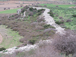
Cyclopean masonry is a type of stonework found in Mycenaean architecture, built with massive limestone boulders, roughly fitted together with minimal clearance between adjacent stones and with clay mortar or no use of mortar. The boulders typically seem unworked, but some may have been worked roughly with a hammer and the gaps between boulders filled in with smaller chunks of limestone.
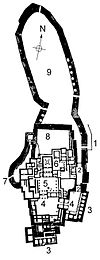
Gla, also called Glas (Γλας), was an important fortified site of the Mycenaean civilization, located in Boeotia, mainland Greece. Despite its impressive size, more than ten times larger than contemporary Athens or Tiryns, Gla is not mentioned in the Iliad.
Greek pyramids, also known as the Pyramids of Argolis, refers to several ancient structures located in the plains of Argolid, Greece. The best known of these is known as the Pyramid of Hellinikon. In the time of the geographer Pausanias it was considered to be a tomb. Twentieth century researchers have suggested other possible uses. The surrounding country of Apobathmi was called Pyramia (Πυράμια), from the monuments in the form of pyramids found there.
The Heraion of Argos is an ancient temple in Argos, Greece. It was part of the greatest sanctuary in the Argolid, dedicated to Hera, whose epithet "Argive Hera" appears in Homer's works. Hera herself claims to be the protector of Argos in Iliad IV, 50–52): "The three towns I love best are Argos, Sparta and Mycenae of the broad streets". The memory was preserved at Argos of an archaic, aniconic pillar representation of the Great Goddess. The site, which might mark the introduction of the cult of Hera in mainland Greece, lies northeast of Argos between the archaeological sites of Mycenae and Midea, two important Mycenaean cities. The traveller Pausanias, visiting the site in the 2nd century CE, referred to the area as Prosymna (Προσύμνη).
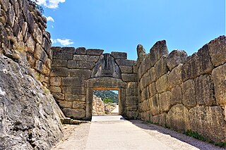
Lion Gate is the popular modern name for the main entrance of the Bronze Age citadel of Mycenae in southern Greece. It was erected during the thirteenth century BC, around 1250 BC, in the northwestern side of the acropolis. In modern times, it was named after the relief sculpture of two lionesses in a heraldic pose that stands above the entrance.
Midea or Mideia (Μίδεια) was a city of ancient Argolis.
The Archaeological Museum of Nafplio is a museum in the town of Nafplio of the Argolis region in Greece. It has exhibits of the Neolithic, Chalcolithic, Helladic, Mycenaean, Classical, Hellenistic and Roman periods from all over southern Argolis. The museum is situated in the central square of Nafplion. It is housed in two floors of the old Venetian barracks.
The Arkadiko Bridge or Kazarma Bridge is a Mycenaean bridge near the modern road from Tiryns to Epidauros in Argolis on the Peloponnese, Greece. The stone crossing, which is dated to the Greek Bronze Age, is one of the oldest arch bridges still in existence which is still crossable today. It is the oldest preserved bridge in Europe.
The Achaeans were one of the four major tribes into which Herodotus divided the Greeks, along with the Aeolians, Ionians and Dorians. They inhabited the region of Achaea in the northern Peloponnese, and played an active role in the colonization of Italy, founding the city of Kroton. Unlike the other major tribes, the Achaeans did not have a separate dialect in the Classical period, instead using a form of Doric.
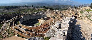
Grave Circle A is a 16th-century BC royal cemetery situated to the south of the Lion Gate, the main entrance of the Bronze Age citadel of Mycenae in southern Greece. This burial complex was initially constructed outside the walls of Mycenae and ultimately enclosed in the acropolis when the fortification was extended during the 13th century BC. Grave Circle A and Grave Circle B, the latter found outside the walls of Mycenae, represents one of the significant characteristics of the early phase of the Mycenaean civilization.
The archaeological site of Menelaion is located approximately 5 km from the modern city of Sparta. The geographical structure of this site includes a hill complex. The archaic name of the place is mentioned as Therapne.
Hermione or Hermium or Hermion was a town at the southern extremity of Argolis, in the wider use of this term, but an independent city during the Classical period of Greek history, and possessing a territory named Hermionis (Ἑρμιονίς). The sea between the southern coast of Argolis and the island of Hydra was called after it the Hermionitic Gulf, which was regarded as distinct from the Argolic and Saronic Gulfs. The ruins of the ancient town lie about the modern village of Ermioni.