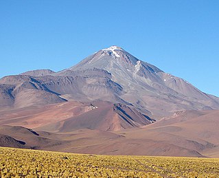
Tittivilla

Last updated
Tittivilla

Txu-oclc-224571173-se19-15.jpg

Tittivilla is the first mountain below the image centre, slightly to the right.
Highest point
Elevation 5,050 m (16,570 ft) [1]
Coordinates 19°43′S68°11′W / 19.717°S 68.183°W / -19.717; -68.183 [1]

Tittivilla (also known as Titivilla or Tetivila) is an eroded volcano in the Andes of Bolivia, on the isthmus separating the Salar de Coipasa in the north from the Salar de Uyuni. The maximum slope in its summit area is 30°. [1] The stratovolcano and neighbouring Tunupa formed 3.5-2.5 mya on NE-SW and NNE-SSW structures, [2] it belongs to the Tungapujo-Guachacoyo volcanic chain. [3] The volcanoes are formed from andesite and dacite belonging to potassium-rich calc-alkaline series. [2]

Volcano A rupture in the crust of a planetary-mass object that allows hot lava, volcanic ash, and gases to escape from a magma chamber below the surface

A volcano is a rupture in the crust of a planetary-mass object, such as Earth, that allows hot lava, volcanic ash, and gases to escape from a magma chamber below the surface.

Andes mountain range running along the tu mamide of South America

The Andes or Andean Mountains are the longest continental mountain range in the world, forming a continuous highland along the western edge of South America. This range is about 7,000 km (4,300 mi) long, about 200 to 700 km wide, and of an average height of about 4,000 m (13,000 ft). The Andes extend from north to south through seven South American countries: Venezuela, Colombia, Ecuador, Peru, Bolivia, Chile and Argentina.

Bolivia country in South America

Bolivia, officially the Plurinational State of Bolivia is a landlocked country located in western-central South America. The capital is Sucre while the seat of government and financial center is located in La Paz. The largest city and principal industrial center is Santa Cruz de la Sierra, located on the Llanos Orientales a mostly flat region in the east of Bolivia.

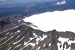
Tittivilla underwent an edifice collapse that triggered a 20 kilometres (12 mi) long debris avalanche. The avalanche descended an altitude of 1,350 metres (4,430 ft) with an azimuth 68° and covered a surface area of 189 square kilometres (73 sq mi). The slide left a 6 kilometres (3.7 mi) wide amphitheatre on the east-northeast side of the volcano that cut through older lava flows, [1] teh amphitheatre was originally interpreted to be an explosion crater. [3]

Azimuth the angle between a reference plane and a point

An azimuth is an angular measurement in a spherical coordinate system. The vector from an observer (origin) to a point of interest is projected perpendicularly onto a reference plane; the angle between the projected vector and a reference vector on the reference plane is called the azimuth.

The northern side of the avalanche has large blocks up to several kilometres of length that are hard to distinguish from eroded lavas from the neighbouring Cerro Grande. The eastern sector contains megablocks and hummocks. The southern part of the slide has a much smaller scale hummocky topography. The topography of the slide was buried by the highstands of the Altiplano lakes and contains lacustrine deposits. The 28000BP Lake Minchin and 50000BP Lake Escara paleolakes certainly submerged the slide deposits. [1]

A hummock is a small knoll or mound above ground. They are typically less than 15 meters in height and tend to appear in groups or fields. It is difficult to make generalizations about hummocks because of the diversity in their morphology and sedimentology. An extremely irregular surface may be called hummocky.

Altiplano plateau

The Altiplano, Collao, Andean Plateau or Bolivian Plateau, in west-central South America, is the area where the Andes are the widest. It is the most extensive area of high plateau on Earth outside Tibet. The bulk of the Altiplano lies in Bolivia, but its northern parts lie in Peru, and its southern parts lie in Chile and Argentina.

Lake Minchin

Lake Minchin is a name of an ancient lake in the Altiplano of South America. It existed where today the Salar de Uyuni, Salar de Coipasa and Lake Poopó lie. It was formerly considered the highest lake in the Altiplano but research indicated that the highest shoreline belongs to the later Lake Tauca instead.

The volcano was active in the Pliocene-Pleistocene. [3] A lava flow within the slide scar is the only clear post-collapse volcanic activity. It originates in the northern part of the slide mouth and continues for 7 kilometres (4.3 mi) to the shores of the Salar de Coipasa. [1]

The Pliocene Epoch is the epoch in the geologic timescale that extends from 5.333 million to 2.58 million years BP. It is the second and youngest epoch of the Neogene Period in the Cenozoic Era. The Pliocene follows the Miocene Epoch and is followed by the Pleistocene Epoch. Prior to the 2009 revision of the geologic time scale, which placed the four most recent major glaciations entirely within the Pleistocene, the Pliocene also included the Gelasian stage, which lasted from 2.588 to 1.806 million years ago, and is now included in the Pleistocene.

The Pleistocene is the geological epoch which lasted from about 2,588,000 to 11,700 years ago, spanning the world's most recent period of repeated glaciations. The end of the Pleistocene corresponds with the end of the last glacial period and also with the end of the Paleolithic age used in archaeology.

Related Research Articles

Parinacota (volcano) Volcano on the border of Chile and Bolivia

Parinacota, Parina Quta or Parinaquta is a dormant stratovolcano on the border of Chile and Bolivia. Together with Pomerape it forms the Nevados de Payachata volcanic chain. Part of the Central Volcanic Zone of the Andes, its summit reaches an elevation of 6,380 metres (20,930 ft) above sea level. The symmetrical cone is capped by a summit crater with widths of 1 kilometre (0.62 mi) or 500 metres (1,600 ft). Farther down on the southern slopes lie three parasitic centres known as the Ajata cones. These cones have generated lava flows. The volcano overlies a platform formed by lava domes and andesitic lava flows.

Licancabur stratovolcano on the border between Bolivia and Chile

Licancabur is a stratovolcano on the border between Bolivia and Chile, south of the Sairecabur volcano and west of Juriques. Part of the Andean Central Volcanic Zone, it has a prominent, 5,916-metre (19,409 ft)-high cone. A 400-metre (1,300 ft) summit crater containing Licancabur Lake, a crater lake which is among the highest lakes in the world, caps the volcano. Three stages of lava flow emanate from the volcano, which formed on Pleistocene ignimbrites.

Aracar mountain in Argentina

Aracar is a large conical stratovolcano in northwestern Argentina, just east of the Chilean border. It has a main summit crater about 1–1.5 kilometres (0.6–0.9 mi) in diameter which sometimes contains crater lakes, and a secondary crater. The volcano has formed, starting during the Pliocene, on top of a lava platform and an older basement. Constructed on a base with an altitude of 4,100 metres (13,500 ft), it covers a surface area of 192.4 square kilometres (74.3 sq mi) and has a volume of 148 cubic kilometres (36 cu mi). The only observed volcanic activity was a possible steam or ash plume on March 28, 1993 seen from the village of Tolar Grande about 50 km (31 mi) southeast of the volcano, but with no evidence of deformation of the volcano from satellite observations. Inca archeological sites are found on the volcano.

Socompa mountain in Argentina

Socompa is a large stratovolcano at the border of Argentina and Chile. Part of the Chilean and Argentine Andean Volcanic Belt (AVB), it is part of the Central Volcanic Zone, one of the various segments of the AVB. This part of the Andean volcanic arc begins in Peru and runs first through Bolivia and Chile, and then through Argentina and Chile, and contains about 44 active volcanoes. Socompa lies close to the pass of the same name, where the Salta-Antofagasta railway crosses the border.

Nevado de Longaví mountain in Chile

Nevado de Longaví is a volcano in the Andes of central Chile. The 3,242 m (10,636 ft) high volcano lies in the Linares Province, which is part of the Maule Region. It features a summit crater and several parasitic vents. The volcano is constructed principally from lava flows. Two collapses of the edifice have carved collapse scars into the volcano, one on the eastern slope known as Lomas Limpias and another on the southwestern slope known as Los Bueye. The volcano features a glacier and the Achibueno and Blanco rivers originate on the mountain.

Quetrupillán

Quetrupillán is a stratovolcano located in the La Araucanía Region of Chile. It is situated between Villarrica and Lanín volcanoes, within Villarrica National Park. Geologically, Quetrupillán is located in a tectonic basement block between the main traces of Liquiñe-Ofqui Fault and Reigolil-Pirihueico Fault.

Aucanquilcha

Aucanquilcha(pronounced: OW-kahn-KEEL-chuh) is a massive stratovolcano located in the Antofagasta Region of northern Chile, just west of the border with Bolivia and within the Alto Loa National Reserve. Part of the Central Volcanic Zone of the Andes, the stratovolcano has the form of a ridge with a maximum height of 6,176 metres (20,262 ft). The volcano is embedded in a larger cluster of volcanoes known as the Aucanquilcha cluster. This cluster of volcanoes was formed in stages over eleven million years of activity with varying magma output, including lava domes and lava flows. Aucanquilcha volcano proper is formed from four units that erupted between 1.04–0.23 million years ago. During the ice ages, both the principal Aucanquilcha complex and the other volcanoes of the cluster were subject to glaciation, resulting in the formation of moraines and cirques.

Ollagüe

Ollagüe or Ullawi is a massive andesite stratovolcano in the Andes on the border between Bolivia and Chile, within the Antofagasta Region of Chile and the Potosi Department of Bolivia. Part of the Central Volcanic Zone of the Andes, its highest summit is 5,868 metres (19,252 ft) above sea level and features a summit crater that opens to the south. The western rim of the summit crater is formed by a compound of lava domes, the youngest of which features a vigorous fumarole that is visible from afar.

San Pedro (Chile volcano) one of the tallest active volcanoes in the world

San Pedro is a Holocene composite volcano in northern Chile and one of the tallest active volcanoes in the world. Part of the Chilean Andes' volcanic segment, it is part of the Central Volcanic Zone of the Andes, one of the four tracts of the Andean Volcanic Belt. This region of volcanism includes the world's two highest volcanoes Ojos del Salado and Llullaillaco. San Pedro, like other Andean volcanoes, was formed by the subduction of the Nazca Plate beneath the South America Plate. It has a neighbouring volcano, San Pablo, and is itself formed by two separate edifices usually known as the Old Cone and the Young Cone. These edifices are formed by rocks ranging from basaltic andesite over andesite to dacite and are emplaced on a basement formed by Miocene volcanic rocks.

Taapaca Volcano in Chile

Taapaca is a Holocene volcanic complex in northern Chile's Arica y Parinacota Region. Located in the Chilean Andes, it is part of the Central Volcanic Zone of the Andean Volcanic Belt, one of four distinct volcanic chains in South America. The town of Putre lies at the southwestern foot of the volcano.

Putana (volcano) South American volcano

Putana, sometimes referred to as Jorqencal or Machuca, is a volcano on the border between Bolivia and Chile and close to the Sairecabur volcanic complex. Part of the Central Volcanic Zone of the Andes, its summit is 5,890 metres (19,320 ft) above sea level and contains a summit crater with two smaller craters nested within it. Beneath the summit, the volcano features a number of lava domes and lava flows, some of which originated in flank vents.

Sollipulli mountain

Sollipulli is an ice-filled volcanic caldera and volcanic complex, which lies southeast of the small town of Melipeuco in the La Araucanía Region, Chile. It is part of the Southern Volcanic Zone of the Andes, one of the four volcanic belts in the Andes chain.

Pumiri Mountain in Bolivia

Pumiri is a 4,862-metre-high (15,951 ft) volcano in the Andes that rises 1,062 metres (3,484 ft) above the surrounding terrain. The volcano is located in the Oruro Department, Sabaya Province, northwest of the Salar de Coipasa.

Cerro Chao

Cerro Chao is a lava flow complex associated with the Cerro del León volcano in the Andes. It is the largest known Quaternary silicic volcano body and part of the most recent phase of activity in the Altiplano–Puna volcanic complex.

Irruputuncu

Irruputuncu is a volcano in the commune of Pica, Tamarugal Province, Tarapacá Region, Chile, as well as San Pedro de Quemes Municipality, Nor Lípez Province, Potosí Department, Bolivia. The mountain's summit is 5,163 m (16,939 ft) high and has two summit craters—the southernmost 200 m (660 ft)-wide one has active fumaroles. The volcano also features lava flows, block and ash flows and several lava domes. The volcano is part of the Andean Central Volcanic Zone (CVZ).

Llullaillaco volcano

Llullaillaco is a dormant stratovolcano at the border of Argentina and Chile. It lies in the Puna de Atacama, a region of tall volcanic peaks on a high plateau close to the Atacama Desert, one of the driest places in the world. It is the second highest active volcano in the world after Ojos del Salado.

Lastarria mountain in Argentina

Lastarria is a volcano that lies on the border between Chile and Argentina. It is part of the Central Volcanic Zone, one of the four segments of the volcanic arc of the Andes. Several volcanoes are located in this chain of volcanoes, which is formed by subduction of the Nazca Plate beneath the South American Plate.

Apacheta-Aguilucho volcanic complex

Apacheta-Aguilucho volcanic complex is a volcanic complex in Chile. It consists of two volcanoes Cerro Apacheta and Cerro Aguilucho, which are constructed mainly by lava flows and surrounded by outcrops of lava. A sector collapse and its landslide deposit are located on Apacheta's eastern flank. Two lava domes are associated with the volcanic complex, Chac-Inca and Pabellón.

Tata Sabaya mountain

Tata Sabaya is a 5,430-metre (17,810 ft) high volcano in Bolivia. It is part of the Central Volcanic Zone, one of several volcanic belts in the Andes which are separated by gaps without volcanic activity. This section of the Andes was volcanically active since the Jurassic, with an episode of strong ignimbritic volcanism occurring during the Miocene. Tata Sabaya lies in a thinly populated region north of the Salar de Coipasa salt pan.

Tutupaca volcano in Peru

Tutupaca is a volcano in the region of Tacna in Peru. It is part of the Peruvian segment of the Central Volcanic Zone, one of several volcanic belts in the Andes. Tutupaca consists of three overlapping volcanoes formed by lava flows and lava domes made out of andesite and dacite, which grew on top of older volcanic rocks. The highest of these is usually reported to be 5,815 metres (19,078 ft) high and was glaciated in the past.

References

  1. 1 2 3 4 5 6 Francis, P. W.; Wells, G. L. (1988). "Landsat Thematic Mapper observations of debris avalanche deposits in the Central Andes". Bulletin of Volcanology . 50 (4): 258–278. doi:10.1007/BF01047488. ISSN   0258-8900.
  2. 1 2 IX Congreso Geológico Chileno: Puerto Varas, 31 de julio al 4 de agosto, 2000 (in Spanish). Sociedad Geológica de Chile. 2000. p. 348.
  3. 1 2 3 Gonzalez-Ferran, Oscar (1994). Volcanes de Chile (1. ed.). Santiago, Chile: Instituto geografico militar. p. 132. ISBN   9789562020541.