Related Research Articles

Albany County is a county in the state of New York, in the United States. Its northern border is formed by the Mohawk River, at its confluence with the Hudson River, which is on the east. As of the 2010 census, the population was 304,204. The county seat is Albany, the state capital of New York. As originally established by the English government in the colonial era, Albany County had an indefinite amount of land, but has had an area of 530 square miles (1,400 km2) since March 3, 1888. The county is named for the Duke of York and of Albany, who became James II of England.
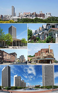
Albany is the capital of the U.S. state of New York and the seat and largest city of Albany County. Albany is located on the west bank of the Hudson River approximately 10 miles (16 km) south of its confluence with the Mohawk River and approximately 135 miles (220 km) north of New York City.

The Albany Pine Bush, referred to locally as the Pine Bush, is one of the largest of the 20 inland pine barrens in the world. It is centrally located in New York's Capital District within Albany and Schenectady counties, between the cities of Albany and Schenectady. The Albany Pine Bush was formed thousands of years ago, following the drainage of Glacial Lake Albany.

Rensselaer Lake is an artificial lake in Albany, New York, United States named for Major-General Stephen Van Rensselaer, last patroon of Rensselaerswyck. The lake was Albany's first municipally-owned source of water. It is part of a 57-acre (23 ha) park and the state's Albany Pine Bush Preserve. The lake and park have been under the purview of the Albany Water Authority since 2003.

The neighborhoods of Albany, New York are listed below.
Van Rensselaer Island was an island in the Hudson River opposite the city of Albany, New York. The island was also known as de Laet's Island, Kalebacker's Island, Boston Island and B&A Island, the last two names in reference to the Boston and Albany Railroad. The island stretched from Mill Creek north to the Livingston Avenue Bridge. Van Rensselaer Island is now connected to the City of Rensselaer, and is no longer an island.
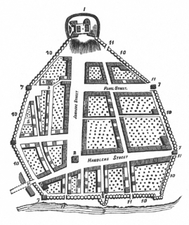
The streets of Albany, New York have had a long history going back almost 400 years. Many of the streets have changed names over the course of time, some have changed names many times. Some streets no longer exist, others have changed course. Some roads existed only on paper. The oldest streets were haphazardly laid out with no overall plan until Simeon De Witt's 1794 street grid plan. The plan had two grids, one west of Eagle Street and the old stockade, and another for the Pastures District south of the old stockade.

Kenwood was a neighborhood in the southern part of the City of Albany, New York. Prior to annexation by the City in 1916, it was a hamlet in the neighboring Town of Bethlehem, also in Albany County. The hamlet once spanned both sides of the Normans Kill along the Albany and Bethlehem Turnpike.
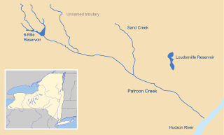
Patroon Creek is a stream in Albany County, New York, United States and is a tributary of the Hudson River which flows south to New York Harbor and the Atlantic Ocean. The creek's source is Rensselaer Lake in the western section of the city of Albany and flows along the northern border of said city with the town of Colonie to its mouth at the Hudson River. The creek received its name from the patroon of Rensselaerswyck.

Downtown Schenectady is the central business district for the city of Schenectady, New York. It originated in the 1820s with the moving of the commercial and industrial interests east from the original 17th and 18th century settlement, spurred on by the development of the Erie Canal. Home to the headquarters and major manufacturing plants of two large corporations, General Electric and American Locomotive Company, Downtown Schenectady catered to tens of thousands of workers in its heyday. Typical of the post-industrial Northeastern United States and Upstate New York in particular, Downtown Schenectady saw a decline in manufacturing and population starting in the 1970s. Recent construction and renovation has caused the downtown area to become an entertainment mecca for New York's Capital District anchored by Proctor's Theatre.
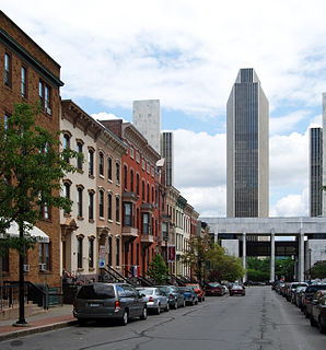
The architecture of Albany, New York, embraces a variety of architectural styles ranging from the early 18th century to the present. The city's roots date from the early 17th century and few buildings survive from that era or from the 18th and early 19th century. The completion of the Erie Canal in 1825 triggered a building boom, which continued until the Great Depression and the suburbanization of the area afterward. This accounts for much of the construction in the city's urban core along the Hudson River. Since then most construction has been largely residential, as the city spread out to its current boundaries, although there have been some large government building complexes in the modernist style, such as Empire State Plaza, which includes the Erastus Corning Tower, the tallest building in New York outside of New York City.

North Albany is a neighborhood in the city of Albany, New York. North Albany was settled in the mid-17th century by the Patroon of Rensselaerswyck and his tenants and later became a hamlet in the town of Watervliet. Due to the Erie Canal being constructed in 1825, North Albany saw immense growth, with the Albany Lumber District and an influx of Irish immigrants lending the area the name of Limerick. Home to many historic warehouses and row houses, North Albany continues to be an important industrial neighborhood. Recent efforts have begun to gentrify the neighborhood by adapting heavy industry/warehouse use to artistic and entertainment venues, such as a German beer garden, an amusement park, live music venues, and arts and crafts marketplaces.

Sheridan Hollow is a neighborhood in Albany, New York located in a ravine north of Downtown Albany. Capitol Hill to the south and Arbor Hill to the north flank the ravine. Often the neighborhood is overlooked by city residents, and outsiders who work in the neighborhood often don't recognize the name of the neighborhood. This is due to the identity of the Hollow being subsumed into its larger neighbor Arbor Hill, for instance news stories of events are often accredited to the wrong neighborhood. Being on undesirable land for development in colonial times, growth was slow in the Hollow and the neighborhood was populated through the centuries by a series of ethnic groups new to Albany, such as the Irish, Polish, and African Americans.

The history of Albany, New York prior to 1664 begins with the native inhabitants of the area and ends in 1664, with the English takeover of New Netherland. The area was originally inhabited by Algonquian Indian tribes and was given different names by the various peoples. The Mohican called it Pempotowwuthut-Muhhcanneuw, meaning "the fireplace of the Mohican nation", while the Iroquois called it Sche-negh-ta-da, or "through the pine woods". Albany's first European structure was a primitive fort on Castle Island built by French traders in 1540. It was destroyed by flooding soon after construction.

The history of Albany, New York from 1860 to 1900 begins in 1860, prior to the start of the Civil War, and ends in 1900.

Lincoln Park is an urban park in Albany, New York, with a unique history, from being the site of a skirmish in 1626 between the Dutch and Mohawks to brickyards and breweries to being Albany's first public playground. The park features Albany's only outdoor non-wading swimming pool, along with several tennis courts, basketball courts, and football and baseball fields. Within the park is the James Hall Office, a National Historic Landmark, and the Thomas O'Brien Academy of Science and Technology (TOAST) an elementary school.

Tricentennial Park is an urban park in Albany, New York built to commemorate that city's three hundredth anniversary as an incorporated city and is the site of several statues and monuments. The park encompasses the entire block bounded by Broadway to the east, Columbia Street to the north, James Street to the west, and Steuben Street to the south. First proposed in 1914 it was built in 1986 as part of the tricentennial celebrations of Albany's incorporation as a city in association with the renovation of the Albany Union Station.

Dana Park is a small .2-acre (810 m2) urban park in Albany, New York and includes a memorial to James Dana which doubles as Albany's last remaining horse trough. It is located in the Y-intersection caused by Delaware Avenue to the east and Lark Street to the west, with the third leg of the triangle formed by Dana Avenue. Madison Avenue forms a five-point intersection with Lark Street and Delaware Avenue at the eastern end of the park. The park is important to several different neighborhoods, Hudson-Park, Park South, and Lark Street.
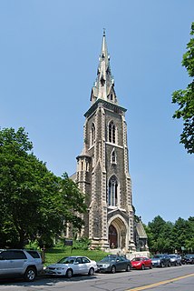
St. Joseph's Church is a historic Gothic church edifice in the Ten Broeck Triangle section of Albany, New York's Arbor Hill neighborhood. The structure is considered a city landmark and an important part of the Albany skyline. The church closed in 1994. As of February 2019, it is owned by the City of Albany.
References
- 1 2 Odata, James (2001-01-16). "Pataki Pledges Aid to City Parks". Times Union (Albany). Hearst Communications. p. B4.
- ↑ Sconfienza, Steve (2010). "Mohawk & Hudson Rail Road".
- ↑ Reynolds, Cuyler (1906). Albany Chronicles: A History of the City Arranged Chronologically from the Earliest Settlement to the Present Time. J.B. Lyon Company. p. 557.
- ↑ Howell, George Rogers; Tenney, Jonathan (1886). Bi-Centennial History of Albany: History of the County of Albany, N.Y., from 1609 to 1886. W.W. Munsell & Company. pp. 582–584.
- ↑ Scruton, Bruce A. (1986-04-23). "Still Having a 'Field Day' Now, as Then, Albany Making the Most of its Parks". The Knickerbocker News. Hearst Communications. p. 4A.
- ↑ Egerton, William S. (1892). The Public Parks of the City of Albany, N.Y. Weed, Parsons, & Co. p. 40.
- 1 2 Lopez, Robert (2005-04-24). "Sprucing Up a Neglected Gem". Times Union (Albany). Hearst Communications. p. D1.
- ↑ Clemans, Alida D. (1986-06-29). "Few Know Nature of Tivoli Park Urban Wilderness Hides in Arbor Hill". Times Union (Albany). Hearst Communications. p. C1.
- ↑ Jochnowitz, Jay (1998-03-25). "Trash-pact Ceremony Irks Critics". Times Union (Albany). Hearst Communications. p. B1.
- ↑ Cappiello, Dina (2002-03-28). "Blazing a Trail for Albany's 'Patroon's Path'". Times Union (Albany). Hearst Communications. p. B1.
- ↑ New York State Department of Environmental Conservation, Division of Fish, Wildlife and Marine Resources. "Lake Map Series: Region 4, Tivoli Lake" (PDF). State of New York.CS1 maint: multiple names: authors list (link)
- ↑ Karlin, Rick (2004-10-28). "Nature's Wonders Within Reach". Times Union (Albany). Hearst Communications. p. B1.
- ↑ Gesensway, Deborah (1988-05-09). "Albany Grows on Urban Farmers". Times Union (Albany). Hearst Communications. p. A1.
